Java, New York facts for kids
Quick facts for kids
Java, New York
|
|
|---|---|

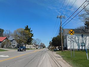
The hamlet of Java Center along Route 78 and Route 98.
|
|

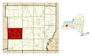
Location within Wyoming County and New York
|
|
| Country | United States |
| State | New York |
| County | Wyoming |
| Area | |
| • Total | 47.33 sq mi (122.58 km2) |
| • Land | 47.13 sq mi (122.06 km2) |
| • Water | 0.20 sq mi (0.52 km2) |
| Elevation | 1,522 ft (464 m) |
| Population
(2010)
|
|
| • Total | 2,057 |
| • Estimate
(2016)
|
1,992 |
| • Density | 42.27/sq mi (16.32/km2) |
| Time zone | UTC-5 (Eastern (EST)) |
| • Summer (DST) | UTC-4 (EDT) |
| ZIP code |
14082
|
| Area code(s) | 585 |
| FIPS code | 36-38341 |
| GNIS feature ID | 0979104 |
Java (/ˈdʒeɪvə/) is a small town in Wyoming County, New York. In 2010, about 2,057 people lived there. The town of Java is located on the western edge of Wyoming County.
Contents
A Look Back: Java's History
The town of Java was started in 1832. It was created from a part of what was then called the Town of China, which is now known as the Town of Arcade. The town was named after the famous island of Java.
Exploring Java's Geography
Java covers an area of about 47.3 square miles (122.58 square kilometers). Most of this area is land, with only a small part being water.
Water Features in Java
The biggest body of water in Java is Java Lake. This lake is actually where the Cattaraugus Creek begins. The creek then flows all the way to Lake Erie.
Java's Location
The western border of Java is also the border of Erie County.
Who Lives in Java: Population Facts
| Historical population | |||
|---|---|---|---|
| Census | Pop. | %± | |
| 1840 | 2,331 | — | |
| 1850 | 2,245 | −3.7% | |
| 1860 | 2,358 | 5.0% | |
| 1870 | 1,956 | −17.0% | |
| 1880 | 1,953 | −0.2% | |
| 1890 | 1,824 | −6.6% | |
| 1900 | 1,770 | −3.0% | |
| 1910 | 1,633 | −7.7% | |
| 1920 | 1,469 | −10.0% | |
| 1930 | 1,403 | −4.5% | |
| 1940 | 1,364 | −2.8% | |
| 1950 | 1,455 | 6.7% | |
| 1960 | 1,757 | 20.8% | |
| 1970 | 1,949 | 10.9% | |
| 1980 | 2,273 | 16.6% | |
| 1990 | 2,197 | −3.3% | |
| 2000 | 2,222 | 1.1% | |
| 2010 | 2,057 | −7.4% | |
| 2016 (est.) | 1,992 | −3.2% | |
| U.S. Decennial Census | |||
In 2000, there were 2,222 people living in Java. The population density was about 47.2 people per square mile. Most of the people living in Java were White.
Households and Families
There were 807 households in the town. Many of these households (35.8%) had children under 18 living with them. About 62.8% of households were married couples living together.
Age Groups in Java
The population was spread out across different age groups. About 27.1% of residents were under 18 years old. Around 11.4% were 65 years or older. The average age in Java was 37 years.
Places and Communities in Java
- Cattaraugus Creek – A river that starts at Java Lake and flows into Lake Erie.
- Curriers – A small community located in the southwest part of the town.
- Hick's Corners – A place found just east of Curriers.
- Java Center – A community located where Route 77 and Route 78 meet.
- Java Lake – A community found on Java Lake Road, near a small lake.
- Java Lake (lake) – This small lake is the starting point for Cattaraugus Creek.
- Java – This community, also called Java Village, is in the northwest part of the town. It is located on Route 78. The historic Java School No. 1 was added to the National Register of Historic Places in 2001.
- North Java – A community in the northeast part of the town. The Arcade and Attica Railroad was listed on the National Register of Historic Places in 1980.
- Waldos Corners – A community located where Route 78 and Route 98 cross.
Schools in Java
Most of Java Town is part of the Yorkshire-Pioneer Central School District. Other school districts that also cover parts of Java Town include Attica Central School District, Holland Central School District, and Warsaw Central School District.
Famous People from Java
- J. W. Eddy – He was the builder of the Angels Flight funicular railroad.
- Ed Don George – Born in North Java in 1905, he was an Olympian in freestyle wrestling at the 1928 Summer Olympics. He later became a professional wrestler.
See also
 In Spanish: Java (Nueva York) para niños


