Jefferson, Oregon facts for kids
Quick facts for kids
Jefferson, Oregon
|
|
|---|---|

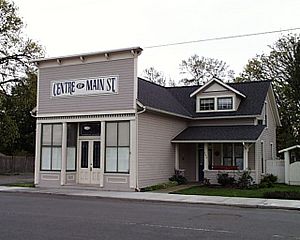
Oliver's House in Jefferson
|
|

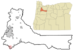
Location in Oregon
|
|
| Country | United States |
| State | Oregon |
| County | Marion |
| Incorporated | 1870 |
| Area | |
| • Total | 0.89 sq mi (2.29 km2) |
| • Land | 0.86 sq mi (2.22 km2) |
| • Water | 0.03 sq mi (0.07 km2) |
| Elevation | 240 ft (70 m) |
| Population
(2020)
|
|
| • Total | 3,327 |
| • Density | 3,882.15/sq mi (1,499.43/km2) |
| Time zone | UTC-8 (Pacific) |
| • Summer (DST) | UTC-7 (Pacific) |
| ZIP code |
97352
|
| Area code(s) | 541 |
| FIPS code | 41-37250 |
| GNIS feature ID | 2410137 |
| Website | City of Jefferson |
Jefferson is a city in Marion County, Oregon, United States. It is part of the larger Salem area. In 2020, about 3,327 people lived there. The city sits on the right side of the Santiam River between Salem and Albany. You can find it along Oregon Route 164 and near Interstate 5.
Contents
History of Jefferson
The first name for this area was Conser's Ferry. This name came from Jacob S. Conser, who was a pioneer on the Oregon Trail in 1848. He started a ferry service across the Santiam River in 1851. Conser also helped create nearby communities like Syracuse and Santiam City. These places were about 2 miles (3.2 km) downstream from where Jefferson is now.
Later, a school called the Jefferson Institute was built in the area. Because of this school, the community eventually adopted the name Jefferson. The Jefferson post office opened in 1861. Its name changed from Syracuse, which had previously been Santiam City.
An important old building in Jefferson is the Jacob Conser House. It was added to the National Register of Historic Places (NRHP) in 1974. This means it is a special historical building. It even served as the city's library until 2018. The bridge over the Santiam River, which is part of Oregon Route 164, was designed by a famous engineer named Conde McCullough. It is named in Jacob Conser's honor. The Jefferson Methodist Church was also added to the NRHP in 1980.
In 2017, some changes happened in the city's leadership. Voters decided to remove the mayor, and three city council members also left. This was due to disagreements about adding new land to the city.
Geography and Climate
According to the United States Census Bureau, the city of Jefferson covers a total area of about 0.77 square miles (1.99 square kilometers). Most of this area, about 0.76 square miles (1.97 square kilometers), is land. A small part, about 0.01 square miles (0.03 square kilometers), is water.
Climate in Jefferson
Jefferson has a climate with warm, dry summers. The average monthly temperatures do not go above 71.6°F (22°C). This type of weather is known as a warm-summer Mediterranean climate. On climate maps, it is often called "Csb."
Population and People
| Historical population | |||
|---|---|---|---|
| Census | Pop. | %± | |
| 1890 | 307 | — | |
| 1900 | 273 | −11.1% | |
| 1910 | 415 | 52.0% | |
| 1920 | 417 | 0.5% | |
| 1930 | 391 | −6.2% | |
| 1940 | 479 | 22.5% | |
| 1950 | 636 | 32.8% | |
| 1960 | 716 | 12.6% | |
| 1970 | 936 | 30.7% | |
| 1980 | 1,702 | 81.8% | |
| 1990 | 1,805 | 6.1% | |
| 2000 | 2,487 | 37.8% | |
| 2010 | 3,098 | 24.6% | |
| 2020 | 3,327 | 7.4% | |
| U.S. Decennial Census | |||
2010 Census Information
In 2010, the city had 3,098 people living in 1,057 households. About 820 of these were families. The population density was about 4,076 people per square mile (1,574 people per square kilometer). There were 1,119 housing units in total.
Most of the people in Jefferson were White (83.8%). There were also smaller percentages of African American (0.2%), Native American (1.7%), Asian (0.5%), and Pacific Islander (0.3%) residents. About 9.6% of the population identified as being from other races, and 3.9% were from two or more races. People who identified as Hispanic or Latino made up 19.2% of the population.
Out of the 1,057 households, 44.3% had children under 18 living with them. About 59.5% were married couples living together. Some households were led by a female (13.3%) or a male (4.7%) without a spouse. About 22.4% of households were not families.
About 16.0% of all households were made up of individuals living alone. Of these, 6.7% had someone aged 65 or older living by themselves. The average household had 2.93 people, and the average family had 3.27 people.
The average age in Jefferson was 32 years old. About 30.5% of residents were under 18. About 8.1% were between 18 and 24. People aged 25 to 44 made up 29.3% of the population. Those aged 45 to 64 were 22.8%, and 9.4% were 65 years or older. The city's population was 48.7% male and 51.3% female.
Education in Jefferson
Public schools in Jefferson are managed by the Jefferson School District. This district includes three schools:
- Jefferson Elementary School
- Jefferson Middle School
- Jefferson High School
A new middle school was built in 2019. This school is located right next to Jefferson High School.
Notable People from Jefferson
- Jeff Gilmour, a politician
- Carol Menken-Schaudt, an Olympic basketball player
- Frederick Steiwer, a politician
See also
 In Spanish: Jefferson (Oregón) para niños
 | Laphonza Butler |
 | Daisy Bates |
 | Elizabeth Piper Ensley |

