Jefferson County, Iowa facts for kids
Quick facts for kids
Jefferson County
|
|
|---|---|

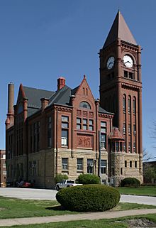
Courthouse in Fairfield is on the NRHP
|
|

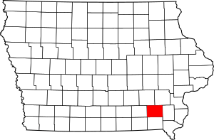
Location within the U.S. state of Iowa
|
|
 Iowa's location within the U.S. |
|
| Country | |
| State | |
| Founded | January 21, 1839 |
| Named for | Thomas Jefferson |
| Seat | Fairfield |
| Largest city | Fairfield |
| Area | |
| • Total | 437 sq mi (1,130 km2) |
| • Land | 436 sq mi (1,130 km2) |
| • Water | 1.4 sq mi (4 km2) 0.3% |
| Population
(2020)
|
|
| • Total | 15,663 |
| • Estimate
(2023)
|
15,440 |
| • Density | 35.84/sq mi (13.839/km2) |
| Time zone | UTC−6 (Central) |
| • Summer (DST) | UTC−5 (CDT) |
| Congressional district | 1st |
| Website | https://jeffersoncounty.iowa.gov/ |
Jefferson County is a county in the state of Iowa. In 2020, about 15,663 people lived here. The main city and county seat is Fairfield. The county was created in January 1839. It was named after Thomas Jefferson, who was a U.S. President. Jefferson County is part of the Fairfield, Iowa, micropolitan area. This means it's a small urban area with a main city.
Contents
Geography
Jefferson County covers about 437 square miles. Most of this area is land, with only a small part being water. The Skunk River flows through the northeast part of the county. The southwest part of the county gets its water from the nearby Des Moines River. This river flows through other counties to the southeast.
Main Roads
Neighboring Counties
- Keokuk County (to the northwest)
- Washington County (to the northeast)
- Henry County (to the east)
- Van Buren County (to the south)
- Wapello County (to the west)
People and Population
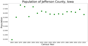
| Historical population | |||
|---|---|---|---|
| Census | Pop. | %± | |
| 1850 | 9,904 | — | |
| 1860 | 15,038 | 51.8% | |
| 1870 | 17,839 | 18.6% | |
| 1880 | 17,469 | −2.1% | |
| 1890 | 15,184 | −13.1% | |
| 1900 | 17,437 | 14.8% | |
| 1910 | 15,951 | −8.5% | |
| 1920 | 16,440 | 3.1% | |
| 1930 | 16,241 | −1.2% | |
| 1940 | 15,762 | −2.9% | |
| 1950 | 15,696 | −0.4% | |
| 1960 | 15,818 | 0.8% | |
| 1970 | 15,774 | −0.3% | |
| 1980 | 16,316 | 3.4% | |
| 1990 | 16,310 | 0.0% | |
| 2000 | 16,181 | −0.8% | |
| 2010 | 16,843 | 4.1% | |
| 2020 | 15,663 | −7.0% | |
| 2023 (est.) | 15,440 | −8.3% | |
| US Decennial Census 1790-1960 1900-1990 1990-2000 2010-2018 |
|||
2020 Census Information
The 2020 census counted 15,663 people living in Jefferson County. This means there were about 36 people per square mile. There were 7,689 homes in the county, and 6,902 of them were lived in.
Here's a look at the different groups of people living in Jefferson County in 2020:
| Race | Number of People | Percentage |
|---|---|---|
| White (not Hispanic) | 13,425 | 85.71% |
| Black or African American (not Hispanic) | 409 | 2.61% |
| Native American (not Hispanic) | 43 | 0.27% |
| Asian (not Hispanic) | 500 | 3.2% |
| Pacific Islander (not Hispanic) | 9 | .06% |
| Other/Mixed (not Hispanic) | 667 | 4.3% |
| Hispanic or Latino | 610 | 4% |
Towns and Areas
Jefferson County has several cities and smaller communities. It is also divided into areas called townships.
Cities
- Batavia
- Coppock (partly in other counties)
- Fairfield
- Libertyville
- Lockridge
- Maharishi Vedic City
- Packwood
- Pleasant Plain
Smaller Communities (Unincorporated)
These are places that are not officially cities or towns.
- Abingdon
- Beckwith
- East Pleasant Plain
- Germanville
- Glasgow
- Perlee
- Salina
Townships
Townships are smaller areas within the county.
- Black Hawk
- Buchanan
- Cedar
- Center
- Des Moines
- Liberty
- Lockridge
- Locust Grove
- Penn
- Polk
- Round Prairie
- Walnut
City Populations (2020)
This table shows the population of the cities in Jefferson County, based on the 2020 census.
† This symbol means it is the county seat, or main city of the county.
| Rank | City/Town/etc. | Type of Place | Population (2020 Census) |
|---|---|---|---|
| 1 | † Fairfield | City | 9,416 |
| 2 | Batavia | City | 430 |
| 3 | Maharishi Vedic City | City | 277 |
| 4 | Libertyville | City | 274 |
| 5 | Lockridge | City | 244 |
| 6 | Packwood | City | 183 |
| 7 | Pleasant Plain | City | 84 |
| 8 | Coppock (most of this city is in Henry and Washington Counties) | City | 36 |
See also
 In Spanish: Condado de Jefferson (Iowa) para niños
 | Emma Amos |
 | Edward Mitchell Bannister |
 | Larry D. Alexander |
 | Ernie Barnes |


