
Jonesport, Maine facts for kids
Quick facts for kids
Jonesport, Maine
|
||
|---|---|---|
 |
||
|
||

Jonesport, Maine
Location in Maine
|
||
| Country | United States | |
| State | Maine | |
| County | Washington | |
| Incorporated | February 3, 1832 | |
| Communities | Jonesport Mason Bay Monsapec West Jonesport |
|
| Area | ||
| • Total | 100.35 sq mi (259.91 km2) | |
| • Land | 28.51 sq mi (73.84 km2) | |
| • Water | 71.84 sq mi (186.06 km2) | |
| Elevation | 23 ft (7 m) | |
| Population
(2020)
|
||
| • Total | 1,245 | |
| • Density | 44/sq mi (16.9/km2) | |
| Time zone | UTC-5 (Eastern (EST)) | |
| • Summer (DST) | UTC-4 (EDT) | |
| ZIP code |
04649
|
|
| Area code(s) | 207 | |
| FIPS code | 23-36010 | |
| GNIS feature ID | 0582537 | |

Jonesport is a small town in Washington County, Maine, United States. In 2020, about 1,245 people lived there. Jonesport is well-known for its fishing and lobstering industries. It includes several smaller communities like Jonesport, Mason Bay, Monsapec, and West Jonesport.
Contents
History of Jonesport
Jonesport was settled even before the American Revolution. In 1789, a large piece of land was given to John C. Jones and others. This area was first named Jonesborough in 1809.
Becoming a Town
On February 3, 1832, a part of Jonesborough became its own town called Jones' Port. Later, in 1925, another part of Jonesport was separated to form the island town of Beals. A bridge was built in 1958 to connect Jonesport and Beals.
Local Industries and Nature
Jonesport is located on a peninsula that stretches about 6 miles (10 km) into the Gulf of Maine. The main jobs here are fishing, building boats, harvesting blueberries, and helping tourists.
The town also includes many islands where no one lives. These islands are important nesting spots for many birds like eider ducks, cormorants, seagulls, razorbills, guillemots, loons, black scoters, grebes, and eagles. There are also two special nature preserves: Western Brothers Island and the Great Wass Archipelago. The Great Wass Archipelago, which includes Great Wass Island, is shared with the town of Beals.
Historical Connection to Israel
In 1866, a group of people from Jonesport sailed all the way to Ottoman-controlled Palestine. They hoped to prepare the land for Jewish people to return. A small, wooden house built by one of these families, called the Maine Friendship House, can still be seen today in Tel Aviv.
Geography of Jonesport
Jonesport covers a total area of about 100.35 square miles (259.91 square kilometers). Most of this area, about 71.84 square miles (186.06 square kilometers), is water. The land area is about 28.51 square miles (73.84 square kilometers).
The town sits on a peninsula between Chandler Bay, Wohoa Bay, and the Indian River. All these waters are part of the Gulf of Maine and the Atlantic Ocean. Islands like Roque Island, Chandler Island, and Great Spruce Island are located offshore.
Neighboring Towns
Maine State Route 187 runs through Jonesport. The town shares its borders with Addison to the west, Jonesboro to the north, and Beals to the south.
Population Information
| Historical population | |||
|---|---|---|---|
| Census | Pop. | %± | |
| 1840 | 576 | — | |
| 1850 | 826 | 43.4% | |
| 1860 | 1,148 | 39.0% | |
| 1870 | 1,305 | 13.7% | |
| 1880 | 1,917 | 46.9% | |
| 1890 | 2,124 | 10.8% | |
| 1900 | 2,074 | −2.4% | |
| 1910 | 2,129 | 2.7% | |
| 1920 | 1,641 | −22.9% | |
| 1930 | 1,641 | 0.0% | |
| 1940 | 1,745 | 6.3% | |
| 1950 | 1,727 | −1.0% | |
| 1960 | 1,563 | −9.5% | |
| 1970 | 1,326 | −15.2% | |
| 1980 | 1,512 | 14.0% | |
| 1990 | 1,525 | 0.9% | |
| 2000 | 1,408 | −7.7% | |
| 2010 | 1,370 | −2.7% | |
| 2020 | 1,245 | −9.1% | |
| U.S. Decennial Census | |||
As of the 2010 census, there were 1,370 people living in Jonesport. Most residents, about 98.1%, identified as White. The average age in the town was 49 years old.
Places to Visit
- Jonesport Historical Society
- Moose Peak Light
- Peabody Memorial Library
Education in Jonesport
Jonesport is part of the Moosabec Community School District. This district includes three schools: Beals Elementary School, Jonesport Elementary School, and Jonesport-Beals High School.
Notable People from Jonesport
- Marv Peasley, a baseball pitcher who played for the Detroit Tigers
- Dana Sawyer, a professor who teaches about religion and philosophy
Images for kids
-
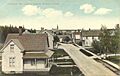
A view of Jonesport in 1908.

See also
 In Spanish: Jonesport (Maine) para niños
