
Kaikorai Stream facts for kids
Quick facts for kids Kaikorai Stream |
|
|---|---|

Kaikorai Stream, Dunedin
|
|


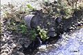
Mouth of the Kaikorai Stream
|
|
| Country | New Zealand |
| Physical characteristics | |
| Main source | Wakari Otago Golf Club 45°51′19″S 170°29′37″E / 45.85539°S 170.49373°E |
| River mouth | Otago Harbour 0 m (0 ft) 45°55′57″S 170°23′25″E / 45.932422°S 170.390194°E |
| Basin features | |
| Progression | Kaikorai Stream → Pacific Ocean |
| Tributaries |
|
The Kaikorai Stream is a short river that flows through Dunedin, a city in New Zealand's South Island. This stream starts in the northwestern parts of Dunedin and flows southwest until it reaches the Kaikorai Lagoon.
The stream was originally called Kaikarae by the Ngāi Tahu Māori. This name refers to a time when petrels (a type of seabird) were caught and eaten near the stream. After European settlers arrived, the stream changed a lot and became known for its poor water quality.
Contents
Understanding the Name: Kaikorai Stream
The name 'Kaikorai' comes from 'kai karae' in the Māori language. This means 'eating petrels'. It's said that a Māori explorer and their group ate these seabirds while camping at the stream's mouth. People first wrote about the Kaikorai Stream in newspapers in 1851.
Even though it's often called Kaikorai Stream, it doesn't have an official name. Some maps even call Fraser's Creek the Kaikorai Stream instead. In 2013, a report suggested the name "should be Kaikarae." Later, in 2023, Kaikarae was recorded as a name for the stream as part of a project with Ngāi Tahu to map Māori place names.
What the Stream Flows Through: Geology

The Kaikorai Stream cuts through different types of rocks. These include older sedimentary and igneous rocks from the late Cretaceous and Tertiary periods. It also flows over younger gravel and soil from the Quaternary period. Near Kaikorai Valley College, the main rock is the Caversham Sandstone, which is about 17 million years old.
The Stream's Journey: Its Course

The stream collects water from the southeastern and eastern slopes of Flagstaff, Kaikorai Hill, and the Balmacewen area. It then flows through Kaikorai Valley and Green Island before emptying into the Kaikorai Estuary. The area that drains into the stream is about 4,100 hectares (10,130 acres) and is home to around 15,000 people. There are two main branches of the stream, both sometimes called 'Kaikorai Stream'.
Balmacewen Branch
One branch of the Kaikorai Stream starts at the Otago Golf Club's Balmacewen Golf Course. From there, it mostly flows through culverts, which are underground pipes. It passes under Bishopscourt, which has sports fields and an intermediate school.
After Bishopscourt, the culvert opens up into a stream that flows through the Shetland Street Community Garden and Kaikorai Common. Near here, you can find a marae (a Māori meeting place) and a retirement village. A special project has created a pond, swampy areas, and a community garden here to protect the wetlands. This land was once planned for a highway.
The stream then goes through pipes again in the suburb of Kaikorai. It flows past the Kaikorai Presbyterian Church and under social housing built where the old Kaikorai Cable Car depot used to be. It continues partly in the open and partly in pipes, some of which are over 100 years old. These pipes are looked after by the Dunedin City Council and run through private properties.
This branch of the Kaikorai Stream is joined by smaller streams, called tributaries, from Halfway Bush. Finally, it flows into the much larger Fraser's Creek.
Fraser's Creek: A Major Water Source
Fraser's Creek provides most of the water for the Kaikorai Stream. It often looks like the main river itself. Extra water from the Deep Stream in the Taieri River area is piped here and released from a city water reservoir. This has been happening since the mid-1970s. It provides cool, clean, high-quality water that wouldn't normally be in the Kaikorai area. When the weather is dry, about two-thirds of the Kaikorai Stream's water comes from this overflow. Fraser's Creek flows through Fraser's Gully, a popular recreation area covered in native bush.
The Lower River's Journey
After the two branches meet, the Kaikorai Stream flows southwest down the wide Kaikorai Valley. It passes through the suburbs of Bradford and Kenmure. In Bradford, the stream flows past the Roslyn Woollen Mills, which used to be a textile mill. Legend says that the color of the blankets being made there could be guessed by the color of the river water!
Students from the nearby Kaikorai Valley College use the stream for outdoor education. They study the water quality and how fast it flows. They also learn fly fishing and check for wastewater.
Many businesses in Kaikorai Valley release wastewater into the stream. This industrial area is one of the few places along the river where there are esplanade reserves, which means the public can easily access the banks.
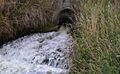
At Burnside, the river turns west and flows through Green Island. Here, it mainly runs in a concrete channel next to the Dunedin Southern Motorway.
Below Green Island, the stream is joined by a big tributary called Abbots Creek. It then continues southwest, finally reaching the Pacific Ocean at Waldronville. Here, its water flows into a lagoon called the Kaikorai Estuary (also known as the Waldronville Lagoon or Kaikorai Lagoon). This lagoon is part of a research project to help monitor estuaries across New Zealand. You can see black swans living there, and sometimes even spoonbills.
Even though the Kaikorai Stream is only about 18 kilometers (11 miles) long, it has been very important to Dunedin's industrial past. Many local businesses, especially the Roslyn Mills, used the stream's power.
Animals and Plants in the Stream
Native aquatic animals that live in the Kaikorai Stream include whitebait, freshwater crayfish (called koura), giant kokopu, longfinned and shortfinned eels, and freshwater mussels.
In 1987, the Otago Regional Council started a program to restore the stream's landscape. This included planting plants along the banks (called riparian vegetation) and making it easier for people to access parts of the stream. In 1996, the Dunedin City Council improved its sanitary landfill at Green Island to reduce harmful liquids (leachate) flowing into the Kaikorai Stream. In the same year, the Dunedin Environment Centre began restoration work at four different spots along the stream.
Stream Pollution: A Historical Look

In 1849, an early settler named Samual Woolley described the stream as having "the purest water." However, by 1907, The Otago Daily Times newspaper called the Kaikorai Stream "a long continuous sewer" and a "sanitary scandal." This pollution was largely due to many industries setting up along the lower part of the stream, especially around Burnside. This area had a freezing works (where meat was processed) and a cement factory. Other businesses that used the stream's water in Dunedin's early days included tanneries, stockyards, a flour mill, a chemical plant, and an iron rolling mill.
The water quality gets worse as the stream flows closer to the sea. Tiny creatures called Macroinvertebrates found in the estuary show that the water is not as healthy there. However, more sensitive species, which need cleaner water, can be found near Kaikorai Valley College, and the water quality gets even better further upstream.
There have been some notable pollution incidents. In 2000, an accidental spill of lime from the Dunedin City Council water treatment plant caused harm to aquatic life, including about 1,000 trout. In 2011, a KFC restaurant accidentally discharged cooking oil into the stream.
Images for kids
-
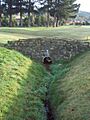
A footbridge on the No 2 fairway at Balmacewen Golf Course: the stream's source
-
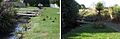
Before and after: planting of the stream banks through Kaikorai Common
-
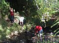
Kaikorai Valley College students study the stream flow.
-
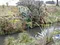
Measuring equipment used to study hydrology
-
Discharge in Green Island
-
Mt Grand overflow.


See also
- Water of Leith, Dunedin's other main urban river
