Kanopolis Lake facts for kids
Quick facts for kids Kanopolis Lake |
|
|---|---|

|
|
| Location | Ellsworth County, Kansas |
| Coordinates | 38°37′58″N 97°59′53″W / 38.63278°N 97.99806°W |
| Type | Reservoir |
| Primary inflows | Smoky Hill River |
| Primary outflows | Smoky Hill River |
| Catchment area | 2,330 sq mi (6,000 km2) |
| Basin countries | United States |
| Managing agency | U.S. Army Corps of Engineers |
| Built | 1948 |
| First flooded | February 17, 1948 |
| Max. length | 12 miles (19 km) |
| Surface area | 3,406 acres (13.78 km2) |
| Max. depth | 35 ft (11 m) |
| Water volume | Full: 49,474 acre⋅ft (61,025,000 m3) Current (Nov. 2015): 47,080 acre⋅ft (58,070,000 m3) |
| Shore length1 | 41 miles (66 km) |
| Surface elevation | Full: 1,463 feet (446 m) Current (Nov. 2015): 1,462.5 feet (445.8 m) |
| Settlements | Kanopolis, Langley, Venango, Yankee Run |
| 1 Shore length is not a well-defined measure. | |
Kanopolis Lake is a large, human-made lake in central Kansas. It is found in Ellsworth County, near the Smoky Hills. The lake is about 31 miles southwest of Salina. It sits a few miles southeast of the town of Kanopolis. The lake was created by the Kanopolis Dam. This dam was finished in 1948. Its main jobs are to control floods and save water. The United States Army Corps of Engineers built and manages the dam.
Contents
How Kanopolis Lake Was Built
The idea for Kanopolis Dam and Lake came from a law called the Flood Control Act of 1938. The United States Army Corps of Engineers started building it in June 1940. However, World War II caused work to stop in 1942. This delayed the project for three and a half years.
The Corps of Engineers finally finished building the dam in 1948. It cost about $12.3 million. Water began filling the lake on February 17, 1948. Kanopolis Lake was the very first lake built by the Corps of Engineers in its Kansas City area. They still look after it today.
Where is Kanopolis Lake?
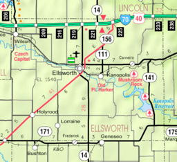
Kanopolis Lake is located in the middle of Kansas. It is part of the Smoky Hills region, which is in the Great Plains. The lake is entirely within Ellsworth County. Its exact location is 38°37′58″N 97°59′53″W / 38.63278°N 97.99806°W. The lake sits at an elevation of about 1,463 feet (446 m) above sea level.
The lake is held back by the Kanopolis Dam at its southeast end. The dam is at 38°37′00″N 97°58′06″W / 38.61667°N 97.96833°W. It is about 1,467 feet (447 m) high. The Smoky Hill River flows into the lake from the northwest. It also flows out of the lake to the southeast. Smaller streams like Alum Creek and Bluff Creek also feed into the lake.
Kansas Highway 141 runs along the east side of the lake. It also goes over the top of the Kanopolis Dam. There are two small communities near the lake. These are Yankee Run on the west side and Venango on the east side.
How Big is the Lake?
The size of Kanopolis Lake can change. This depends on how much water flows in and the weather. When the lake is full, it covers about 3,406 acres (13.78 km2) of land. At this point, its surface is about 1,463 feet (446 m) above sea level. It holds about 49,474 acre⋅ft (61,025,000 m3) of water.
When the lake is completely full, it can hold much more water. Its surface can reach 1,532 feet (467 m) high. At this level, it covers about 23,408 acres (94.73 km2). The deepest part of the lake is about 35 feet (11 m).
The bottom of the lake was originally about 1,406 feet (429 m) deep. Over time, mud and dirt have settled on the bottom. This has made the lake bed a bit higher. When the lake is full, it has about 41 miles (66 km) of shoreline. During floods, the shoreline can grow to 135 miles (217 km).
Lake Infrastructure
Kanopolis Dam is a large wall made of earth and rocks. It has a special layer of rocks on its front side. This helps protect it from the water. The dam is about 131 feet (40 m) tall. It is also very long, stretching for about 15,360 feet (4,680 m). The very top of the dam is about 1,537 feet (468 m) high.
Who Manages the Lake?
The United States Army Corps of Engineers manages Kanopolis Dam and Lake. They have several important jobs. These include reducing flood damage and providing a place for fun activities. They also help manage fish and wildlife. They make sure there is enough water and that it is good quality.
The Corps also looks after about 11,000 acres (45 km2) of land around the lake. They work to bring back native grasslands. They also do controlled burns and plant trees. This helps keep the soil healthy and supports wildlife. They also let local farmers use some land. These farmers must follow rules that help wildlife.
The Kansas Department of Wildlife, Parks and Tourism (KDWP) also helps manage the land. They look after over 5,000 acres (20 km2) as the Smoky Hill Wildlife Area. Part of this area is a special wildlife refuge. This means it is a safe place for animals. The KDWP also adds fish to the lake at different times of the year.
Fun Things to Do at Kanopolis Lake
There are many fun things to do at Kanopolis Lake! The Corps of Engineers runs three parks: Venango Park, Outlet Park, and Riverside Park. Venango Park is the biggest. It is on the east side of the lake. Here you can find campgrounds, hiking trails, and even an ATV trail. There is also a swimming beach and a boat ramp.
Outlet Park is a smaller park right below the dam. Riverside Park is nearby and has camping spots. The Corps of Engineers also has an Information Center below the dam. You can also find Boldt Bluff and Yankee Run areas on the west side of the lake. These are great for fishing and simple camping.
The KDWP manages Kanopolis State Park. This park has two main areas. The Horsethief Area is on the east side of the lake. The Langley Point Area is on the south side, near the dam. Both areas have outdoor theaters, boat ramps, and places to camp. The Horsethief Area has many hiking trails. Some of these trails go into the Smoky Hill Wildlife Area. The Langley Point Area also has a baseball field, a marina, and a swimming beach. The KDWP also looks after Mushroom Rock State Park. This park is about 4 miles (6.4 km) north of the lake.
Kanopolis Lake is a popular spot for fishing. You can catch many types of fish here. There are also almost 16,000 acres (65 km2) of public land near the lake. Much of this land is upstream along the Smoky Hill River. This area is open for hunting.
Cool Places to See
The Faris Caves are a unique place to visit. They are located in the Smoky Hill Wildlife Area. These caves were carved into sandstone cliffs by early settlers. They were once used as a school, homes, and even a place to store milk.
Animals and Plants at the Lake
Many different types of fish live in Kanopolis Lake. These include channel catfish, crappie, largemouth bass, saugeye, walleye, white bass, and wiper.
You can also find many game animals around the lake. These include coyotes, deer, pheasants, prairie chickens, rabbits, quail, squirrels, and turkeys. Various waterfowl (birds that live near water) are also common. In the winter, Bald eagles and ospreys fly through the area.
 | Stephanie Wilson |
 | Charles Bolden |
 | Ronald McNair |
 | Frederick D. Gregory |


