Karnali Province facts for kids
Quick facts for kids
Karnali Province
कर्णाली प्रदेश
Karnali Pradesh
|
||
|---|---|---|
|
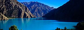
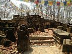
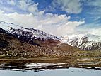
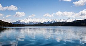
From top going clockwise:Phoksundo lake, Sinja Valley, Simikot, Rara lake, ruins of Kakre Bihar in Surkhet and Kanjiroba
|
||
|
||
Location of Karnali Province
|
||
|
Divisions of Karnali Province
|
||
| Country | ||
| Formation | 20 September 2015 | |
| Capital | Birendranagar | |
| Largest city | Birendranagar | |
| Districts | 10 | |
| Government | ||
| • Type | Self governing province | |
| • Body | Government of Karnali Province | |
| Area | ||
| • Total | 27,984 km2 (10,805 sq mi) | |
| Area rank | 1st | |
| Population
(2021)
|
||
| • Total | 1,694,889 | |
| • Rank | 7th | |
| • Density | 60.5664/km2 (156.8662/sq mi) | |
| • Density rank | 7th | |
| Demonym(s) | Madhya Pashchimeli Nepali | |
| Time zone | UTC+5:45 (NST) | |
| Geocode | NP-SI | |
| Official Language | Nepali | |
| Other Official Languages | 1.Khas-Jumli 2.Magar |
|
| HDI | 0.469 (low) | |
| HDI rank | 7th | |
| Literacy | 62.77% | |
| GDP | US$1.44 billion | |
| GDP rank | 7th | |
| Website | www.karnali.gov.np | |
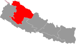
Karnali Province (Nepali: कर्णाली प्रदेश) is one of the seven provinces in Nepal. It was created when Nepal adopted its new constitution on September 20, 2015. Karnali is the largest province in Nepal, covering about 18.97% of the country's land. Its total area is 27,984 square kilometres (10,805 sq mi).
Even though it's the biggest in size, Karnali Province has the fewest people in Nepal. In 2011, about 1,570,418 people lived there. The province shares borders with Tibet Autonomous Region (China) to the north, Gandaki Province to the east, Sudurpashchim Province to the west, and Lumbini Province to the south. Birendranagar is both the capital and the largest city in Karnali Province.
Contents
What's in a Name?
The province gets its name from the Karnali River. This important river flows right through the area. The local government, called the provincial assembly, officially chose the name "Karnali" on February 25, 2018.
A Look Back in Time
Karnali has a very old history in Nepal, closely linked to the Karnali River. Archaeological finds in places like Jumla, Surkhet, and Dailekh show that this area was once part of the ancient Khasa kingdom. This kingdom started around the 11th century.
The capital of the Khasa Kingdom was Sinja, which is in today's Jumla District. This kingdom grew very large in the 13th and 14th centuries. It stretched from Garhwal in the west to Mansarowar and Guge in Tibet to the north. It also reached Gorkha and Nuwakot in the east, and Kapilvastu in the south.
After the late 14th century, the Khasa empire broke apart. It split into many smaller kingdoms known as the Baise Rajya (22 principalities). These were located in the Karnali and Bheri regions. Before modern Nepal was formed, these 22 small kingdoms were independent. They sometimes worked together until Nepal united them between 1744 and 1810.
Exploring Karnali's Geography
Karnali is the biggest province in Nepal, covering an area of 27,984 km2 (10,805 sq mi). It is bordered by Gandaki Province to the east, Lumbini Province to the south, Sudurpashchim Province to the west, and the Tibet Autonomous Region of China to the north.
The province includes high mountains in the north and mid-hills in Nepal. You can find mountains like Kubi Gangri, Changla, and Kanjiroba here. Shey Phoksundo National Park, which has Phoksundo lake, is Nepal's largest national park. Also, Rara lake, the biggest lake in Nepal, is located in Karnali Province. The Karnali River is the largest river in the province and is believed to be the longest river in Nepal. Other important rivers include the Seti River and Bheri River, which flow into the Karnali. Kupinde Daha is another lake in Karnali.
People and Culture
According to the 2021 Census of Nepal, Karnali Province has a population of 1,688,412 people. This includes 864,651 females and 823,761 males. It has the lowest population among all provinces in Nepal. The province has about 56 people living per square kilometer.
Who Lives Here?
Castes/ethnicities in Karnali province (2011) Chhetri (41.61%) Kami (15.84%) Magar (10.88%) Thakuri (10.29%) Hill Brahmin (8.36%) Damai (3.98%) Sarki (2.63%) Sanyasi (1.69%) Others (4.72%)
The largest group of people in Karnali Province are the Khas Arya. This group includes Chhetri, Kami, Thakuri, and Hill Brahmin communities. The largest group that is not Khas Arya is the Magars, who make up about 10.88% of the population. Other groups with a notable population include Tamang and Gurung.
Languages Spoken
Languages of Karnali province (2011) Nepali (95.55%) Magar (2.07%) Others (2.38%)
Most people in Karnali Province, about 95.55%, speak Nepali as their first language. Other languages spoken here are Magar (2.07%) and Tamang (0.72%). The Language Commission of Nepal has suggested that Magar language should also be an official language in the province. Nepali, the main language, is sometimes called Khas Bhasha in this region.
Religions
Religion in Karnali Province Hinduism (95.34%) Buddhism (3.09%) Christianity (1.30%) Others (0.27%)
Hinduism is the most common religion in Karnali Province. About 95.34% of the people follow Hinduism. Buddhists are the largest minority religious group, making up 3.09% of the population. Christianity is the second-largest minority religion, followed by 1.30% of the people.
How Karnali is Governed
The province has a Governor who acts as the head of the province. The Chief Minister leads the provincial government. The main judge of the Surkhet High Court is in charge of the justice system. Currently, the Governor is Tilak Pariyar, and the Chief Minister is Jeevan Bahadur Shahi.
Karnali has a single legislative body, like other provinces in Nepal. This body is called the Provincial Assembly of Karnali Province. Its members serve for five years. The Provincial Assembly is currently located in the Irrigation Division Office in Birendranagar.
Local Divisions
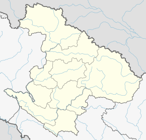
Karnali Province is divided into ten districts. Each district is managed by a District Coordination Committee and a District Administration Officer. These districts are further divided into municipalities (cities) or rural municipalities (villages), which then have smaller sections called wards.
There are 25 municipalities and 54 rural municipalities in Karnali Province. Birendranagar is the capital and the largest city. It is the only city in the province with more than 50,000 people.
| Districts | Headquarters | Population (2011) |
|---|---|---|
| Western Rukum District | Musikot | 155,383 |
| Salyan District | Salyan | 242,444 |
| Dolpa District | Dunai | 36,700 |
| Humla District | Simikot | 50,858 |
| Jumla District | Chandannath | 108,921 |
| Kalikot District | Manma | 136,948 |
| Mugu District | Gamgadhi | 55,286 |
| Surkhet District | Birendranagar | 350,804 |
| Dailekh District | Narayan | 261,770 |
| Jajarkot District | Khalanga | 171,304 |
Economy and Life
Karnali Province has the slowest economic growth in Nepal. It also contributes the least to the country's total economic output. Many people in Karnali live in poverty. About 28.9% of people live in extreme poverty, and 51.7% are considered multidimensionally poor. The unemployment rate in the province is 9.7%.
Farming in Karnali
Karnali is a major producer of barley in Nepal. In 2018/19, it produced 43% of the country's total barley.
Environment and Water
In 2023, it was estimated that over 96% of people in Karnali Province have to drink contaminated water. Only about 3% of citizens in the province have access to clean drinking water. This is a big challenge for the region.
See also
 In Spanish: Provincia de Karnali para niños
 | Emma Amos |
 | Edward Mitchell Bannister |
 | Larry D. Alexander |
 | Ernie Barnes |


