
Kearny, Arizona facts for kids
Quick facts for kids
Kearny, Arizona
|
|
|---|---|

Kearny Historic Marker
|
|
| Motto(s):
"The Heart of the Copper Basin"
|
|

Location of Kearny in Pinal County, Arizona.
|
|
| Country | United States |
| State | Arizona |
| County | Pinal |
| Incorporated | 1959 |
| Area | |
| • Total | 2.74 sq mi (7.09 km2) |
| • Land | 2.70 sq mi (6.98 km2) |
| • Water | 0.04 sq mi (0.11 km2) |
| Elevation | 1,860 ft (567 m) |
| Population
(2020)
|
|
| • Total | 1,741 |
| • Density | 645.77/sq mi (249.35/km2) |
| Time zone | UTC-7 (MST (no DST)) |
| ZIP code |
85137
|
| Area code(s) | 520 |
| FIPS code | 04-37200 |
| GNIS feature ID | 6633 |
| Website | Town of Kearny |
Kearny is a town in Pinal County, Arizona, USA. It's named after General Stephen Watts Kearny. He traveled through this area in 1846 with 100 soldiers called dragoons.
In 2020, about 1,741 people lived in Kearny. The main industry in Kearny and nearby towns is copper mining. The Ray mine and Hayden Smelter are important places where copper is dug up and processed. They are run by a company called ASARCO.
Contents
History of Kearny, Arizona
Kearny was built by the Kennecott Mining Company in 1958. It was a special "planned community." This means it was designed to be a new home for people from nearby towns like Ray, Sonora, and Barcelona. These towns were going to be covered by Kennecott's growing open-pit copper mine.
Many houses in Kearny were new. But some mine workers even had their old homes moved to the new town! Kearny officially became a town in 1959.
Geography and Climate
Kearny is located at 33°3′15″N 110°54′32″W / 33.05417°N 110.90889°W. The town is near the Gila River in an area known as the Copper Basin. Other towns like Hayden and Winkelman are also close by.
The town covers about 2.74 square miles (7.09 square kilometers) of land.
Kearny's Weather Patterns
Kearny has a type of weather called a warm-summer Mediterranean climate. This means it usually has hot, dry summers and mild, wet winters.
Population of Kearny
| Historical population | |||
|---|---|---|---|
| Census | Pop. | %± | |
| 1960 | 902 | — | |
| 1970 | 2,829 | 213.6% | |
| 1980 | 2,646 | −6.5% | |
| 1990 | 2,262 | −14.5% | |
| 2000 | 2,249 | −0.6% | |
| 2010 | 1,950 | −13.3% | |
| 2020 | 1,741 | −10.7% | |
| U.S. Decennial Census | |||
In 2000, there were 2,249 people living in Kearny. There were 791 households, which are groups of people living together. Most people in Kearny were White, and a good number were also Hispanic or Latino.
About 35% of households had children under 18 living with them. Many households were married couples. The average household had about 2.84 people. The average family had about 3.25 people.
The population was spread out by age. About 30% were under 18 years old. About 14% were 65 years or older. The average age in Kearny was 37 years.
Education in Kearny
Kearny is part of the Ray Unified School District. This district has two schools:
- Ray Junior-Senior High School
- Ray Elementary School
Transportation Options
Kearny Airport is located in the southern part of the town. In 2003, it won an award from the Arizona Department of Transportation.
The airport has one asphalt runway. It is 3,400 feet (1,036 meters) long and 60 feet (18 meters) wide. The airport is 1,833 feet (559 meters) above mean sea level.
Images for kids
-
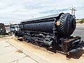
Porter Air Locomotive built in 1925
-
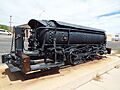
Different view of the Porter Air Locomotive
-
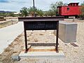
Rail and Copper Park
-
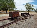
Mining Cars in the Rail and Copper Park
-
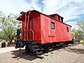
The Jake Jacobson Caboose in the Rail and Copper Park
-
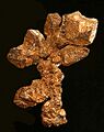
Native copper from the nearby Ray Mine
-
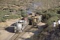
Copper Basin Railway trains at Ray Junction in Kearny, around 1987


.jpg)
See also
 In Spanish: Kearny (Arizona) para niños
