Kemah, Texas facts for kids
Quick facts for kids
Kemah, Texas
|
|
|---|---|

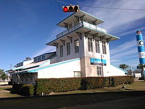
Kemah Community Center
|
|
| Nickname(s):
"Gateway to the Bay"
|
|

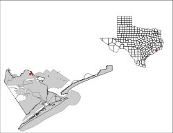
Location of Kemah, Texas
|
|
| Country | United States |
| State | Texas |
| County | Galveston |
| Area | |
| • Total | 1.91 sq mi (4.96 km2) |
| • Land | 1.85 sq mi (4.78 km2) |
| • Water | 0.07 sq mi (0.17 km2) |
| Elevation | 7 ft (2 m) |
| Population
(2020)
|
|
| • Total | 1,807 |
| • Density | 946.1/sq mi (364.3/km2) |
| Time zone | UTC-6 (Central (CST)) |
| • Summer (DST) | UTC-5 (CDT) |
| ZIP code |
77565
|
| Area code(s) | 281 |
| FIPS code | 48-38776 |
| GNIS feature ID | 1339021 |
Kemah is a small city in Texas, located southeast of Houston. It sits right on the western side of Galveston Bay. In 2020, about 1,807 people lived there. Kemah used to be a quiet fishing town. Today, it is a popular place for tourists. People visit for its many restaurants and fun attractions. The city is known as the "Gateway to the Bay." In 2012, Kemah was even named the top tourist spot in the Greater Houston area.
Contents
Kemah's Location and Size
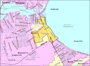
Kemah is in the northeast part of Galveston County. It is part of the Clear Lake Area. To its west and south is League City. Clear Lake Shores is to the northwest. Seabrook is across the Clear Creek Channel to the north.
Texas State Highway 146 runs through Kemah. This highway connects Kemah to Baytown (about 15 miles north) and Texas City (about 12 miles south). Galveston is 25 miles south. Houston is about 30 miles northwest.
The city covers about 1.91 square miles (4.94 square kilometers). Most of this area is land, with a small part being water.
Kemah's History and Growth
Early Days and New Names
The land where Kemah now stands was first given to a farmer named Michael Gouldrich in 1824. Later, the land changed hands many times. It was even called "Flanders Grove" for a while.
In the 1890s, two families, the Bradfords and the Kipps, moved to the area. They divided the land into smaller lots in 1898. This created a new town called "Evergreen." It was located near the Texas and New Orleans Railroad. The area was also known as "Shell Siding" because of the large piles of oyster shells along the bay.
Rebuilding and a New Name
In 1900, a huge hurricane hit Galveston. Most towns around Galveston Bay were destroyed. The Kipp and Bradford families had to leave. But they came back in 1901 and rebuilt their town. They even built two-story homes with porches.
To get a post office, the town needed a new name. There was already another town called Evergreen. So, they chose "Kemah." This name comes from the Karankawa Indian language. It means "wind in my face." In 1907, the first post office opened in Kemah.
Kemah as a Tourist Spot
From the 1920s to the 1950s, Kemah became a popular place for tourists. People came to enjoy the area. During the 1950s, the state worked to stop certain activities. This caused tourism in Kemah to slow down.
In the 1950s, a large shrimp fishing fleet started in Kemah. The Clear Creek Channel was opened, which helped the fishing business. Even after Hurricane Carla caused damage in 1961, the city rebuilt. Fishing became strong again.
In the 1970s, tourism started to grow once more. This was partly because the Johnson Space Center was built nearby. More and more pleasure boats began to fill Clear Lake.
Modern Kemah and the Boardwalk
On October 22, 1966, Kemah officially became a General Law City. By 1992, the city grew to about 2 square miles. The number of people living there also increased to 1,300.
In the late 1990s, Kemah became a major tourist and fun spot. This happened when Landry's Restaurants opened the Kemah Boardwalk. The boardwalk now has many amusement rides and attractions. Both tourists and local people enjoy them.

On September 13, 2008, Hurricane Ike hit Galveston County. Kemah was also affected by this strong storm. The hurricane caused power outages. Homes and businesses were damaged. Streets were covered with trees and debris. The storm surge hit the Kemah Boardwalk hard. Landry's quickly rebuilt the boardwalk. A waterline in the Landry's Restaurant still reminds people of the powerful hurricane.
Who Lives in Kemah?
| Historical population | |||
|---|---|---|---|
| Census | Pop. | %± | |
| 1970 | 1,144 | — | |
| 1980 | 1,304 | 14.0% | |
| 1990 | 1,094 | −16.1% | |
| 2000 | 2,330 | 113.0% | |
| 2010 | 1,773 | −23.9% | |
| 2020 | 1,807 | 1.9% | |
| U.S. Decennial Census | |||
In 2020, 1,807 people lived in Kemah. There were 778 households and 578 families.
| Race | Number | Percentage |
|---|---|---|
| White (NH) | 1,170 | 64.75% |
| Black or African American (NH) | 62 | 3.43% |
| Native American or Alaska Native (NH) | 3 | 0.17% |
| Asian (NH) | 87 | 4.81% |
| Pacific Islander (NH) | 1 | 0.06% |
| Some Other Race (NH) | 8 | 0.44% |
| Mixed/Multi-Racial (NH) | 74 | 4.1% |
| Hispanic or Latino | 402 | 22.25% |
| Total | 1,807 |
Education in Kemah
Students in Kemah go to schools in the Clear Creek Independent School District (CCISD). This school district was started in 1948. It was partly formed from the old Kemah school district.
Students in Kemah attend:
- Stewart Elementary School (in Galveston County)
- Bayside Intermediate School (in League City)
- Clear Falls High School (in League City)
Before, students went to League City Intermediate School and Clear Creek High School.
Residents of the Clear Creek ISD area can also attend the College of the Mainland. This is a community college in Texas City.
See also
 In Spanish: Kemah (Texas) para niños
 | Delilah Pierce |
 | Gordon Parks |
 | Augusta Savage |
 | Charles Ethan Porter |


