Keyes Gap facts for kids
Quick facts for kids Keyes Gap |
|
|---|---|
| Elevation | 906 ft (276 m) |
| Traversed by | |
| Location | Loudoun County, Virginia / Jefferson County, West Virginia, United States |
| Range | Blue Ridge Mountains Appalachian Mountains |
| Coordinates | 39°16′N 77°46′W / 39.26°N 77.76°W |
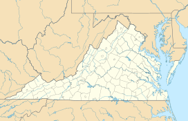
Keyes Gap is a special kind of low spot in the Blue Ridge Mountains. It sits right on the border between Loudoun County, Virginia and Jefferson County, West Virginia. This gap is a "wind gap," which means it's a valley or pass that was once carved by a river. However, the river has since changed its course.
Today, two important roads, Virginia State Route 9 and West Virginia Route 9, cross through Keyes Gap. The famous Appalachian Trail, a long hiking path, also goes through this area.
Contents
A Look Back at Keyes Gap's History
Early Days: Vestal's Gap
Keyes Gap was first known as Vestal's Gap. It is one of the lowest places to cross the Blue Ridge Mountains in Virginia. The gap is about 906 feet (276 meters) high.
During the time of the American colonies, this gap was very important. It was part of the main road connecting the towns of Alexandria and Winchester.
French and Indian War Connection
In the 1750s, a major conflict called the French and Indian War took place. During this war, part of General Edward Braddock's army marched through Keyes Gap. A young George Washington was also with them. They were on their way to Fort Duquesne, a French fort.
Changing Importance Over Time
By the year 1820, a new road called the Snickers Gap Turnpike was finished. This new road crossed the Blue Ridge Mountains further south at Snickers Gap. Because of this, Keyes Gap became less important for travel.
However, Keyes Gap still played a role during the American Civil War. It was a useful "back route" from Virginia to Harpers Ferry. Harpers Ferry was a very important location during the war.
 | Valerie Thomas |
 | Frederick McKinley Jones |
 | George Edward Alcorn Jr. |
 | Thomas Mensah |


