Khajuraho facts for kids
Quick facts for kids
Khajuraho
|
|
|---|---|
|
City
|
|

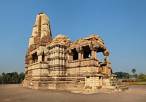
Dulhadeo Temple
|
|
| Country | |
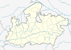
| State | Madhya Pradesh |
| District | Chhatarpur |
| Elevation | 283 m (928 ft) |
| Population
(2011)
|
|
| • Total | 24,481 |
| Time zone | UTC+5:30 (IST) |
| Vehicle registration | MP-16 |
| Sex ratio | 1100 ♂/♀ |
Khajuraho is a city located near Chhatarpur in the Indian state of Madhya Pradesh. It is famous for having India's largest collection of medieval Hindu and Jain temples. These amazing temples are known as the Khajuraho Group of Monuments.
Since 1986, the Khajuraho temples have been a UNESCO World Heritage Site. Many people consider them one of the "seven wonders" of India. The city's name, "Kharjuravahaka" in ancient times, comes from a Sanskrit word meaning "date palm".
Contents
Discover the History of Khajuraho
Khajuraho has been part of many powerful kingdoms and empires over time. Early rulers included the Vatsa and later the Mauryans. Other important groups were the Guptas and the Gurjara-Praithara dynasty. During the Gupta period, art and architecture really started to grow here.
The Chandela Dynasty and Temple Building
The Chandelas began ruling the area in the ninth century. They were initially under the Gurjara-Praitharas. Around 950 to 1002 AD, under King Dhanga, the Chandelas became independent. This was a very important time for Khajuraho. Many of the grand temples you see today were built during their rule.
Decline and Rediscovery
The Chandela rule faced challenges from other groups. Khajuraho slowly became a smaller village. The Chandelas moved their main activities to other forts.
In 1202, a traveler named Ibn Battuta visited Khajuraho. He wrote about the temples and some holy people living there. Sadly, some temples were damaged in 1495.
Khajuraho became less important for a long time. It was "rediscovered" in 1819 by C. J. Franklin, a military surveyor. However, T. S. Burt, a British army captain, truly brought Khajuraho back to the world's attention in 1838. Later, Alexander Cunningham explored the site between 1852 and 1855.
Khajuraho's Climate
| Climate data for Khajuraho (1981–2010, extremes 1970–2010) | |||||||||||||
|---|---|---|---|---|---|---|---|---|---|---|---|---|---|
| Month | Jan | Feb | Mar | Apr | May | Jun | Jul | Aug | Sep | Oct | Nov | Dec | Year |
| Record high °C (°F) | 34.3 (93.7) |
38.6 (101.5) |
43.1 (109.6) |
46.9 (116.4) |
48.4 (119.1) |
48.0 (118.4) |
45.0 (113.0) |
41.0 (105.8) |
39.3 (102.7) |
42.8 (109.0) |
37.6 (99.7) |
32.8 (91.0) |
48.4 (119.1) |
| Mean daily maximum °C (°F) | 24.1 (75.4) |
28.0 (82.4) |
34.3 (93.7) |
40.1 (104.2) |
42.8 (109.0) |
40.4 (104.7) |
34.3 (93.7) |
32.5 (90.5) |
33.2 (91.8) |
33.8 (92.8) |
30.1 (86.2) |
26.1 (79.0) |
33.3 (91.9) |
| Mean daily minimum °C (°F) | 8.4 (47.1) |
10.8 (51.4) |
15.8 (60.4) |
21.9 (71.4) |
26.9 (80.4) |
28.4 (83.1) |
26.3 (79.3) |
25.3 (77.5) |
24.1 (75.4) |
19.0 (66.2) |
13.3 (55.9) |
9.2 (48.6) |
19.1 (66.4) |
| Record low °C (°F) | 1.0 (33.8) |
0.6 (33.1) |
6.3 (43.3) |
12.6 (54.7) |
18.6 (65.5) |
21.5 (70.7) |
22.4 (72.3) |
21.8 (71.2) |
17.3 (63.1) |
11.7 (53.1) |
4.8 (40.6) |
3.1 (37.6) |
0.6 (33.1) |
| Average rainfall mm (inches) | 17.8 (0.70) |
22.8 (0.90) |
10.6 (0.42) |
6.5 (0.26) |
15.7 (0.62) |
100.0 (3.94) |
293.7 (11.56) |
377.0 (14.84) |
211.6 (8.33) |
33.9 (1.33) |
6.7 (0.26) |
3.8 (0.15) |
1,100 (43.31) |
| Average rainy days | 1.3 | 1.6 | 0.9 | 0.8 | 1.5 | 5.5 | 13.0 | 13.6 | 8.7 | 1.7 | 0.5 | 0.6 | 49.9 |
| Average relative humidity (%) (at 17:30 IST) | 47 | 37 | 24 | 17 | 20 | 40 | 69 | 76 | 68 | 48 | 44 | 48 | 45 |
| Source: India Meteorological Department | |||||||||||||
Khajuraho's Population
According to the Indian census in 2011, Khajuraho had 24,481 people. About 52% of the population were males, and 48% were females.
The average literacy rate in Khajuraho was 53%. This means 53 out of every 100 people could read and write. This was lower than the national average of 74.04% at that time. For males, the literacy rate was 62%, and for females, it was 43%. Also, 19% of the people in Khajuraho were under six years old.
Getting Around Khajuraho
Air Travel to Khajuraho
Khajuraho Airport offers flights to major cities like Delhi and Varanasi. The airport is located about 3 kilometers south of Khajuraho Town. It first opened in 1978 to make it easier for tourists to visit the nearby UNESCO world heritage site, the temple complex.
Train Travel to Khajuraho
The Khajuraho railway station connects the town by train. A daily train, the Kurukshetra-Khajuraho Express (11842), runs from New Delhi. This journey takes about 13 and a half hours.
Another daily train, the Vande Bharat (22470) Express, connects Khajuraho to H.Nizamuddin (New Delhi). This faster train takes about 8 hours and 20 minutes. Khajuraho also has daily train connections to cities like Agra, Jaipur, Bhopal, and Udaipur. A local daily train goes to Kanpur, and Varanasi is connected three times a week.
See also
 In Spanish: Khajuraho para niños
 | Precious Adams |
 | Lauren Anderson |
 | Janet Collins |


