Kingman Lake facts for kids
Quick facts for kids Kingman Lake |
|
|---|---|

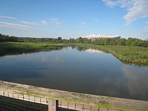
A view of the northern portion of Kingman Lake on the west side of Kingman Island, facing south
|
|
| Location | Washington, D.C. |
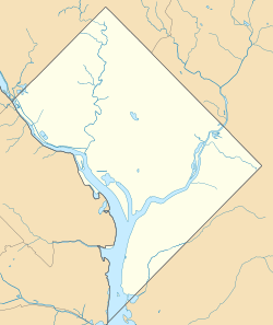
| Coordinates | 38°53′47.41″N 76°57′55.91″W / 38.8965028°N 76.9655306°W |
| Type | Artificial |
| Primary inflows | Anacostia River |
| Primary outflows | Anacostia River, evaporation |
| Basin countries | United States |
| Built | 1920 |
| Surface area | 110 acres (0.45 km2) |
| Average depth | 6 feet (1.8 m) |
| Islands | 4 (Kingman Island, Heritage Island, Island No. 3, Island No. 4) |
| Settlements | Washington, D.C. |
Kingman Lake is a 110-acre (0.45 km2) artificial lake located in the Anacostia River in Washington, D.C., United States. It was created in 1920 by the United States Army Corps of Engineers. They used dirt and mud dug up from the Anacostia River to build Kingman Island. This island largely blocked the river's flow to its west, forming the lake. Some water still enters the lake to keep it from drying up and to keep its waters fresh. Today, the National Park Service manages Kingman Lake.
Contents
How Kingman Lake Was Formed
The Anacostia River's Early Days
Before European settlers arrived in the 1700s, the Anacostia River was a fast-moving river. It had very little mud or marshy areas. However, settlers cleared many forests for farms. This led to a lot of soil washing into the Anacostia, making it muddy.
Over time, bridges were built across the river, like Benning Bridge. These bridges and the use of streams for farming slowed the river's flow. This allowed mud and dirt to settle and build up.
Mudflats and Health Concerns
Between 1860 and the late 1880s, large muddy areas called "the Anacostia flats" formed along the riverbanks. At this time, the city's dirty water flowed directly into the Anacostia. Marsh plants grew in these muddy areas, trapping the dirty water.
Public health experts worried that these flats were unhealthy. They also feared the flats were perfect breeding grounds for malaria- and yellow fever-carrying mosquitoes. By the late 1800s, these mudflats were covered with plants like American lotus and wild rice.
Dredging and Park Creation
In 1898, officials decided the Anacostia River needed to be dredged. This meant digging out the bottom of the river. The goal was to create a deeper channel for boats and to make new land for factories or warehouses. The material dug from the river would be used to fill in the muddy flats. This would turn them into dry land and remove the health risks. Most of these reclaimed mudflats later became Anacostia Park in 1919.
Early plans included building a dam across the Anacostia River. This dam would create a large lake for fishing and boating. They also planned to use the dredged material to build islands within this new lake. By 1920, the idea of a dam was dropped. Instead, the United States Army Corps of Engineers decided to create a 6 feet (1.8 m) deep lake on one side of the river. They did this by connecting several mid-river islands with dikes. This is how Kingman Lake was formed.
Developing Kingman Lake
Naming the Lake and Early Improvements
By 1926, the Corps of Engineers started calling the new lake Kingman Lake. It was named after Brigadier General Dan Christie Kingman, a respected former head of the Corps.
Improvements continued around the lake. A rock and concrete wall was built around Kingman Lake to protect its edges. Gates were also installed at the north and south ends of the lake. These gates helped keep the water level constant. In 1929, parts of Kingman Lake were deepened by dredging.
Addressing Pollution and Ownership Changes
In the early 1930s, the problem of dirty water flowing into Kingman Lake and the Anacostia River became a big concern. The Army Corps of Engineers spent money to extend Washington's sewer system. This helped collect dirty water before it flowed into the river and lake.
In 1934, the Corps of Engineers gave ownership of the Anacostia Flats and Kingman Lake to the National Park Service. Work on the lake stopped in 1941 because of World War II.
By the mid-1950s, health issues at Kingman Lake were still a problem. A scientist found that the lake's bottom was very polluted. People were warned not to swim in the lake because of the dirty water. This was mainly due to low water flow and a lack of locks to help water move out of the lake.
In the 1960s, there were ideas to develop Kingman Lake. Boating was banned in 1961. There were also proposals to fill in parts of the lake to add land to Langston Golf Course. However, these plans were never carried out.
Kingman Lake Today

Since 1999, many ideas have been suggested for Kingman Lake. Most of these ideas focus on keeping the lake as one of the few wild areas left in the city.
In September 1999, the Army Corps of Engineers began changing parts of Kingman Lake back into a tidal marsh. This means removing some of the walls and creating new marshland. The goal was to plant thousands of water plants in these new marsh areas. This work helps restore the natural environment of the lake. Scientists also monitored the changes in the tidal marsh for several years to see how it improved.
 | James Van Der Zee |
 | Alma Thomas |
 | Ellis Wilson |
 | Margaret Taylor-Burroughs |


