
Kit Carson Mountain facts for kids
Quick facts for kids Kit Carson Mountain |
|
|---|---|
| Kit Carson Peak | |

The Crestones as seen from Mount Adams.
From left to right: Crestone Needle, Crestone Peak, Columbia Point, Kit Carson Peak, and Challenger Point. |
|
| Highest point | |
| Elevation | 14,171 ft (4,319 m) |
| Prominence | 1,025 ft (312 m) |
| Isolation | 1.27 mi (2.04 km) |
| Listing | Colorado Fourteener 23rd |
| Geography | |

Kit Carson Mountain
Location in Colorado
|
|
| Location | Saguache County, Colorado, United States |
| Parent range | Sangre de Cristo Range, Crestones |
| Topo map | USGS 7.5' topographic map Crestone Peak, Colorado |
| Climbing | |
| Easiest route | Scramble Class 2 |
Kit Carson Peak, officially known as Kit Carson Mountain, is a very tall mountain in Colorado, United States. It's part of the Crestones, a group of high peaks in the Sangre de Cristo Range. This range is a section of the larger Rocky Mountains in North America.
Standing at 14,171-foot (4,319 m) high, Kit Carson Peak is one of Colorado's famous "fourteeners". These are mountains that reach over 14,000 feet (about 4,267 meters) in height. The mountain is found in Saguache County, about 5.2 miles (8.4 km) east of the Town of Crestone.
The mountain is named after Christopher Houston "Kit" Carson, a famous American frontiersman. The Crestones area includes other notable peaks like Crestone Peak, Crestone Needle, Challenger Point, Humboldt Peak, and Columbia Point.
Contents
Protecting Kit Carson Mountain
In 2002, an organization called the Nature Conservancy helped protect a large area of land. They bought the Baca Ranch, which included Kit Carson Mountain. This purchase helped expand the Great Sand Dunes National Park and Preserve in 2004.
Because of this, Kit Carson Mountain became part of the Sangre de Cristo Wilderness. This wilderness area is managed by the Rio Grande National Forest. This helps protect the mountain and its natural surroundings for everyone to enjoy.
Climbing Kit Carson Peak

Climbing Kit Carson Mountain is a popular adventure for experienced hikers. One common way to reach the top starts from the west side. This route begins at the Willow Creek Trailhead, which is about 8,900 ft or 2,700 m high.
Hikers on this route first climb Challenger Point, which is a peak next to Kit Carson. After reaching Challenger Point, climbers cross a path known as 'Kit Carson Avenue'. This path leads them towards the main summit of Kit Carson Peak. The entire trip involves climbing about 6,250 ft (1,905 m) in elevation. The round-trip journey is about 14 miles (23 km) long.
You can also climb Kit Carson from the east side of the Sangre de Cristos. This route uses trails that lead to the South Colony Lakes. It involves hiking part of the trail for Humboldt Peak. Then, climbers cross a ridge and a flat area towards Kit Carson. On this route, you will also climb a smaller peak called Columbia Point, sometimes known as "Kat Carson," before reaching the main summit.
Mountain Weather and Safety
Kit Carson Mountain does not have large, permanent ice sheets called glaciers. However, it does have a patch of ice on its rugged north side. This ice patch often stays frozen even during the warmest and driest parts of the year.
During the summer, Kit Carson and the nearby peaks often experience thunderstorms. These storms can form quickly, and lightning can happen almost every day. Climbers need to be very careful and watch the weather closely.
It's important for climbers to stay on marked paths. Sometimes, a steep valley between Kit Carson's summit and Challenger Point might look like a shortcut. But this valley can be dangerous. It leads to icy areas and steep cliffs with loose rocks. It's much safer to follow the main climbing routes.
Images for kids
-
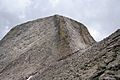
Kit Carson Peak as seen from the saddle between it and Challenger Point.

