
Klingnau facts for kids
Quick facts for kids
Klingnau
|
||
|---|---|---|
 |
||
|
||

Klingnau
Location in Switzerland

Klingnau
Location in Canton of Aargau
|
||
| Country | Switzerland | |
| Canton | Aargau | |
| District | Zurzach | |
| Area | ||
| • Total | 6.71 km2 (2.59 sq mi) | |
| Elevation | 328 m (1,076 ft) | |
| Population
(Dec 2020 )
|
||
| • Total | 3,540 | |
| • Density | 527.6/km2 (1,366.4/sq mi) | |
| Postal code |
5313
|
|
| Surrounded by | Böttstein, Döttingen, Koblenz, Leuggern, Rietheim, Zurzach | |

Klingnau is a small town, also called a municipality, located in the Aargau canton of Switzerland. It's part of the Zurzach district.
Contents
History of Klingnau
How Klingnau Was Founded
Klingnau was first mentioned in records in 1239. A person named Ulrich of Klingen bought land from the St. Blaise monastery. He wanted to build a new town there. He also made a deal about which farmers from the monastery could move to his new town.
The Klingen family gave a lot of land around the city to the Knights Hospitaller. This happened between 1251 and 1268. These knights owned so much land that they moved their main house to Klingnau in 1268. They even had their own special gate in the city walls.
Changes in Ownership and Rights
In 1269, Walther of Klingen sold the town to his cousin. This was Eberhard von Waldburg, the Bishop of Constance. The new owner then chose a bailiff to manage the town. A bailiff was like a local governor.
Klingnau became the center of a larger area. This area included nearby places like Koblenz and Döttingen. In 1314, Klingnau was given "town privileges." This meant citizens could elect their own town council and a court every year.
From 1415 to 1798, Klingnau was one of three special districts. These districts were part of the county of Baden under the Swiss Confederation.
Challenges and Disasters
The town's growth was often stopped by big problems. In 1586, a huge fire destroyed 84 houses. This was a major disaster for the town.
Diseases also caused problems. The plague hit Klingnau in 1611 and 1635. The plague in 1611 killed 226 people. This was about one-third of everyone living there.
Later, a typhoid sickness spread in 1813–1814. It killed about 3,000 people in and around Klingnau. Many of these were soldiers fighting against Napoleon. They were buried in a large grave north of the town.
Modern Developments
To stop bad floods, the Aare river's path was changed between 1885 and 1904. Later, a dam was built on the river from 1931 to 1935. This created the Klingnau power plant.
The lake formed by the dam, called Klingnauer Stausee, became a resting place for birds. It was made a special protected area in 1989.
Religious Buildings
Klingnau's main church, St. Catherine, was built in 1491. It was for the Catholic community. A smaller chapel, the Loreto Chapel, was built between 1660 and 1662. A Reformed church was built much later, in 1935.
Klingnau Castle
The building of Klingnau Castle started around 1240. It was first the home of the Klingen family. Over time, outer walls were added. The Bishop of Constance often stayed there in the 1300s.
By the late 1500s, the castle was in bad shape. In 1804, it became property of the new Canton of Aargau. It was sold in 1817 and used by different businesses. Later, a foundation took it over to protect it.
Economy and Industry
People in Klingnau mostly earned money from farming, crafts, and making wine. Klingnau wine was sold a lot in the 1200s and 1300s. In 1780, there were about 115 hectares (284 acres) of vineyards.
However, a plant disease called phylloxera hurt the wine industry after 1900. It didn't fully recover until after 1930.
Around 1840, the first factories appeared. These made things like raw silk, woven goods, and straw products. When the railway line was built in 1859, it helped the economy grow more. A shoe factory (Bally Shoes), a cigar box factory, and a baby carriage factory opened.
For many years, Klingnau was known for its wood and furniture companies. By 2000, nearly half of all jobs in the town were in industry.
Geography of Klingnau
Klingnau covers an area of about 6.71 square kilometers (2.59 square miles). About 38% of this land is used for farming. Forests cover about 34.7% of the area. Buildings and roads make up about 19.2% of the land.
The town is located on the right side of the lower Aare river valley. It sits between the Klingnauer Stausee lake and the Achenberg hill. The village itself is on a rocky area. This spot used to be an island in the Aare river. Over time, the river's side channel filled up with dirt. Now, the town is no longer an island.
Klingnau's Coat of Arms
The town's coat of arms shows a red shield. On it is a black bishop's hat (called a mitre) with gold lining. There are also two gold stars on either side of the hat.
People of Klingnau
Klingnau has a population of 3,540. About 25.9% of the people living here are from other countries. Most people in Klingnau speak German (89.2%). Italian is the second most common language (3.6%), followed by Albanian (2.6%).
Age Groups in Klingnau
Here's a look at the different age groups in Klingnau:
- Children (0-9 years old): 7.9% of the population.
- Teenagers (10-19 years old): 11.5% of the population.
- Young adults (20-29 years old): 15.0% of the population.
- Adults (30-59 years old): 41.6% of the population.
- Seniors (60 years and older): 23.9% of the population.
Homes and Households
In Klingnau, about 60.6% of homes are owned by the people living in them. In 2000, there were 1,125 homes and apartments in the town. On average, about 2.4 people lived in each home.

Important Heritage Sites
The old Provost's house of the St. Blasien Abbey is a very important building. It is listed as a Swiss heritage site of national significance. This means it's a special place that is protected because of its history and culture. The entire village of Klingnau is also recognized as part of the Inventory of Swiss Heritage Sites.
Klingnau's Economy
In 2007, Klingnau had a low unemployment rate of 2.15%. This means most people who wanted to work had jobs.
Jobs in Klingnau are divided into three main types:
- Primary sector: This includes jobs like farming. About 50 people work in this area.
- Secondary sector: This includes jobs in factories and making things. About 406 people work here.
- Tertiary sector: This includes jobs in services, like shops, offices, and schools. About 420 people work in this area.
Many people who live in Klingnau travel outside the town for work. In 2000, about 80% of residents worked in other places. About 15% of workers used public transportation to get to their jobs. Most, about 54.3%, used a private car.
Religion in Klingnau
Based on a 2000 count, most people in Klingnau are Roman Catholic, making up 57.3% of the population. About 23.5% belong to the Swiss Reformed Church. A small number, about 0.18%, are part of the Christian Catholic faith.
Education in Klingnau
Many adults in Klingnau have a good education. About 74.2% of people aged 25–64 have finished high school or gone on to higher education.
In the 2008/2009 school year, Klingnau had:
- 168 students in primary school.
- 105 students in secondary school.
- 132 students in university-level schooling.
Klingnau also has a regional library called Regionalbibliothek Klingnau. In 2008, it had over 12,400 books and other items. It loaned out more than 48,000 items that year.
Notable People from Klingnau
- Sebastian Peregrin Zwyer (1597 – 1661): A Swiss military leader and politician. He was likely born in Klingnau.
- Hans Schleuniger (born 1933): A Swiss former professional racing cyclist who competed in the 1960 Tour de France.
Images for kids
-
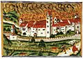
The great fire of 1586 destroyed many homes.
-
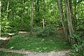
A mass grave from the typhoid sickness in 1813–14.
-
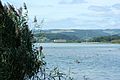
The hydroelectric power plant and reservoir at Klingnau.
-
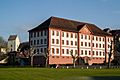
The historic Provost's house.
-
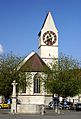
The church in Klingnau.


See also
 In Spanish: Klingnau para niños
