Knob Mountain (Pennsylvania) facts for kids
Quick facts for kids Knob Mountain |
|
|---|---|

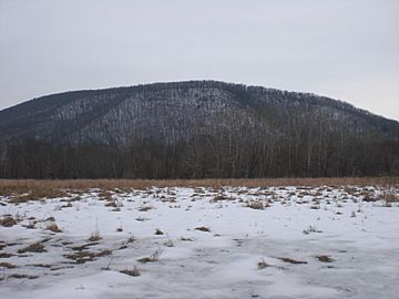
Knob Mountain from the west
|
|
| Highest point | |
| Elevation | 1,720 ft (520 m) |
| Listing | Lee Mountain, Huntington Mountain |
| Geography | |
| Parent range | Appalachians |
| Climbing | |
| Easiest route | Road |
Knob Mountain (sometimes called Nob Mountain) is a long, narrow mountain in northeastern Columbia County, Pennsylvania. Parts of it also reach into Luzerne County, Pennsylvania. This mountain stands tall at over 1,720 feet above sea level. You can see Knob Mountain from far away, even from the town of Bloomsburg. Its peak is one of the highest spots in Columbia County.
Contents
Knob Mountain's Location and Landscape
Knob Mountain starts near Orangeville in the west. It stretches eastward and a little northward for about 10 to 12 miles (16 to 20 kilometers). Then, it slopes down to the flat land around it, just past the Luzerne County line.
There's also a slightly lower peak called Huntington Mountain. This peak extends in the same direction as Knob Mountain, reaching as far as Shickshinny.
How Steep is Knob Mountain?
Knob Mountain is quite steep. The northern side is steeper than the southern side. The base of the mountain sits in the areas where water flows into Fishing Creek and Huntington Creek. At one point, Fishing Creek makes a sharp turn around the bottom of Knob Mountain. The mountain's shape is mostly smooth, but there is a small dip or "notch" near its eastern end.
Rocks and Coal
A special ridge of rocks and dirt, called a terminal moraine, runs from nearby Lee Mountain. It goes to the southern base of Knob Mountain and then over Knob Mountain to Fishing Creek.
Near its peak, Knob Mountain has rough, hard sandstone. It is also part of the Wyoming coal basin. This coal basin is a long chain of areas that have coal, stretching between Lackawanna County and Dauphin County. The Wyoming and Lackawanna coal fields end right at Knob Mountain. There is also a basin of red shale rock found under the mountain.
Lee Mountain and Huntington Mountain are close to Knob Mountain. You can think of them as extensions of Knob Mountain that reach further east.
Climbing Knob Mountain
You can reach Knob Mountain from any direction. Two roads actually cross over the main part of the mountain. The highest point on the entire mountain ridge is over 1,720 feet high.
History of the Area
People first started settling near Fishing Creek and Knob Mountain in 1780. However, many more settlers arrived in the area around Knob Mountain in 1785. These early settlers mostly came from New Jersey. They traveled to the mouth of Fishing Creek near Berwick. From there, they moved up the creek's valley to the area close to Knob Mountain. At that time, this was the northernmost settlement by non-native people in the Fishing Creek area.
A small community was built at the base of the mountain in 1822. Long ago, a path used by Native Americans once crossed over the mountain near its eastern end. The old Susquehanna and Tioga Turnpike also used to go over Knob Mountain. In the past, a pile of stones on top of Knob Mountain was even used to mark a township border.
Animals and Plants
Knob Mountain has thick forests at its peak. The land around the mountain is mostly used for farming. In the early days, when people first settled in the area, they often believed that many wolves and bears lived on Knob Mountain.
 | Stephanie Wilson |
 | Charles Bolden |
 | Ronald McNair |
 | Frederick D. Gregory |


