Koksoak River facts for kids
Quick facts for kids Koksoak River |
|
|---|---|

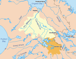
Drainage basin of the Koksoak River in yellow. Diverted basin of the Caniapiscau River in orange.
|
|
| Other name(s) | Rivière Koksoak |
| Country | Canada |
| Province | Quebec |
| Region | Nord-du-Québec |
| Physical characteristics | |
| River mouth | Ungava Bay About 50 km NNE from Kuujjuaq 0 m (0 ft) 58°32′11″N 68°09′29″W / 58.53639°N 68.15806°W |
| Length | 137 km (85 mi) |
| Basin features | |
| Basin size | 133,400 km2 (51,500 sq mi) |
The Koksoak River (also called rivière Koksoak in French) is a big river in northern Quebec, Canada. It's the largest river in the Nunavik area. The Inuit village of Kuujjuaq is located right on the river's banks. Kuujjuaq is also the main town for the region.
What's in a Name?
The name Koksoak probably came from missionaries. These missionaries worked with the Inuit people a long time ago. They might have misspelled the Inuktitut word Kuujjuaq. This word means "great river."
In the 1800s, people also called this river the Big River or South River. This was because Ungava Bay was sometimes called South Bay back then. In 1916, the name Koksoak became official.
Where the River Flows
The Koksoak River starts where two other rivers meet. These are the Rivière aux Mélèzes (to the west) and the Caniapiscau River (to the south). This meeting point is about 80 kilometres (50 mi) southwest of Kuujjuaq.
From there, the Koksoak River flows for about 80 kilometres (50 mi) towards the northeast. It passes by the village of Kuujjuaq. Then, it flows north for another 50 kilometres (31 mi) until it reaches Ungava Bay.
If you add the length of the Koksoak River and its longest branch, the Caniapiscau River, it's about 874 kilometres (543 mi) long. The area of land that drains into the river (its basin) is huge. It covers about 133,000 square kilometres (51,000 sq mi).
The James Bay Project
In 1985, something big happened to the Caniapiscau River. Some of its upper waters were redirected. This was part of a large project called the James Bay Project. Now, about 45% of the Caniapiscau's water flows differently. It goes through the Caniapiscau Reservoir. From there, it flows into the LaForge and La Grande Rivers to the west. This change affects how much water flows into the Koksoak River.
River Environment
The Koksoak River has a lot of water flowing through it each year. Scientists estimate about 55 cubic kilometers of water. However, it's hard to get exact numbers. This is because there aren't many long-term records of the river's flow.
Most of the water flows in early summer. This is when the river's ice melts. Also, the snow in the Canadian Shield melts at this time.
The Koksoak River is located where two types of land meet. To the south, there's the edge of the taiga (boreal forest). To the north, there are vast open lands called tundra. These tundra areas are part of the Ungava Peninsula.
All the land in the Koksoak basin has permafrost. This means the ground stays frozen all year round. In the south, it's "discontinuous" permafrost, meaning some spots thaw. In the north, it's "continuous," meaning it's always frozen.
Fun Activities
Life in Kuujjuaq mainly involves hunting and administrative services. But adventure tourism is also growing! Many visitors come for caribou hunting. Fishing is also very popular. People enjoy catching salmon, trout, and Arctic char.
Tributaries
Here are some of the important rivers and creeks that flow into the Koksoak River (listed from the mouth upstream):
- Highfall Creek
- Kupatalik River
- Ujaralialuk River
- Caniapiscau River
- Forbes River
- Situraviup River
- Andréas River
- Sérigny River
- Swampy bay River
- Rivière aux Mélèzes
- Aigneau River
- Lefebvre River
- Ikirtuuq River
- Rivière du Gué
- Guignas River
- Delay River
- Potier River
See also
 In Spanish: Río Koksoak para niños
 | Kyle Baker |
 | Joseph Yoakum |
 | Laura Wheeler Waring |
 | Henry Ossawa Tanner |

