Caniapiscau Reservoir facts for kids
Quick facts for kids Caniapiscau Reservoir |
|
|---|---|
 |
|
| Location | Caniapiscau / Baie-James, Quebec, Canada |
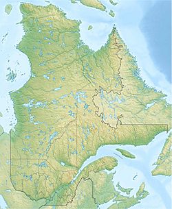
| Coordinates | 54°09′27″N 69°50′44″W / 54.15750°N 69.84556°W |
| Type | Artificial |
| Primary inflows | Caniapiscau River |
| Primary outflows | Laforge River, Caniapiscau River |
| Catchment area | 36,800 km2 (14,200 sq mi) |
| Basin countries | Canada |
| Max. length | 120 km (75 mi) |
| Max. width | 135 km (84 mi) |
| Surface area | 4,318 km2 (1,667 sq mi) |
| Max. depth | 49 m (161 ft) |
| Water volume | 53.8 km3 (12.9 cu mi) |
| Residence time | 2.2 years |
| Shore length1 | 4,850 km (3,010 mi) |
| Surface elevation | 535 m (1,755 ft) |
| Islands | 300 |
| Settlements | Caniapiscau |
| 1 Shore length is not a well-defined measure. | |
| Top - 0-9 A B C D E F G H I J K L M N O P Q R S T U V W X Y Z |
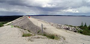
The Caniapiscau Reservoir (in French: Réservoir de Caniapiscau) is a very large artificial lake in the northern part of Quebec, Canada. It is the biggest body of water in Quebec and the second largest reservoir in all of Canada.
This huge reservoir was created by building two dams and forty-three dikes. It is the largest reservoir by surface area that is part of the James Bay Project. This project helps create electricity for many homes and businesses. The Caniapiscau Reservoir acts like a giant storage tank, feeding water to the power plants of the La Grande complex. In winter, it can provide up to 35% of the electricity they produce! The area that collects water for the reservoir is about 36,800 square kilometres (14,200 sq mi).
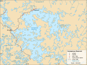
The reservoir got its name from Lake Caniapiscau, a natural lake that was flooded when the reservoir was made. The name comes from the Cree or Innu languages, kâ-neyâpiskâw, which means "rocky point." An explorer named Albert Peter Low noted in 1895 that a "high rocky headland" stuck out into the lake. This rocky point probably gave the reservoir its unique arc shape that we see today.
The Caniapiscau Reservoir is quite remote. You can reach it by small plane or by a gravel road called the Trans-Taiga Road, which was built in 1981. At the very end of this road, there's a former work site called Caniapiscau. No one lives permanently at the reservoir. However, it is used by companies that organize hunting and fishing trips. Some Cree people also use it for traditional fishing and trapping. Because it's so isolated, there are very few gas stations or other services nearby.
How the Reservoir Was Made
The natural lakes in this region formed about nine thousand years ago. This happened after huge glaciers slowly moved across Quebec for ninety thousand years, shaping the land. At first, these lakes drained south towards the Gulf of Saint Lawrence. But as the land slowly rose in the south, the water started flowing north instead. It flowed into the Caniapiscau River, which then joined the Koksoak River, eventually reaching Ungava Bay.
Before the reservoir was built, Lake Caniapiscau was much smaller, covering about 470 square kilometres (180 sq mi). In the 1800s, hunters and fur traders often visited it. The Hudson's Bay Company even had an outpost there from 1834 to 1870. This outpost helped connect their trading posts in the James Bay area with those in Ungava Bay.
In 1976, a company called Société d'énergie de la Baie James, which is part of Hydro-Québec, started building the Caniapiscau Reservoir. The goal was to create a large water source for the hydro-electric power stations of the James Bay Project. The reservoir began filling with water on October 25, 1981. Over the next three years, it flooded many natural lakes, including Caniapiscau, Delorme, Brisay, Tournon, and Vermouille.
Today, the reservoir fills a low area in the highest part of the Canadian Shield. It now covers 4,318 square kilometres (1,667 sq mi), which is about four times bigger than the natural lakes were before they were flooded! Since August 1985, some of the Caniapiscau River's water has been sent west into the Laforge River. This river is part of the La Grande River system, which flows west into James Bay.
When the reservoir was created, many new islands appeared. In 1997, a Quebec government group named these islands after important works of Quebec literature. However, this caused some disagreement. Leaders from the Cree and Inuit First Nations pointed out that these places already had traditional native names, which were not used.
Plants and Nature
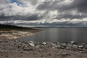
The area around the Caniapiscau Reservoir is in a zone of "discontinuous permafrost." This means that the ground is frozen for most of the year, but not everywhere and not all the time.
The land around the reservoir is covered in taiga, also known as a boreal forest. This type of forest has Black Spruce trees that are spread far apart. The ground beneath them is often covered with a thick layer of yellow-grey lichen. You'll also find wet, spongy areas called muskeg and bogs. In places where there is more moisture, you might see thicker groups of evergreen trees. In more open areas, the forest slowly changes into a tundra landscape, where trees are replaced by land mostly covered in lichen.
See also
 In Spanish: Embalse de Caniapiscau para niños
 | Jackie Robinson |
 | Jack Johnson |
 | Althea Gibson |
 | Arthur Ashe |
 | Muhammad Ali |


