
Kololo Peaks facts for kids
Quick facts for kids Kololo Peaks |
|
|---|---|

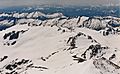
Kololo Peaks seen from Pacific Crest Trail
|
|
| Highest point | |
| Elevation | 8,200 ft (2,500 m) |
| Prominence | 880 ft (270 m) |
| Geography | |

Kololo Peaks
Location in Washington (state)

Kololo Peaks
Location in the United States
|
|
| Location | Snohomish County, Washington Chelan County, Washington, U.S. |
| Parent range | Cascade Range |
| Topo map | USGS Glacier Peak East |
| Climbing | |
| Easiest route | Scrambling |

Kololo Peaks is a tall mountain in Washington state. It stands at 8,200+ ft (2,500+ m) high. This mountain is part of the Glacier Peak Wilderness area. You can find it in the North Cascades mountain range.
Kololo Peaks sits right on the edge of the Cascade Range. It is on the border between Snohomish County and Chelan County. It also divides the Mount Baker-Snoqualmie National Forest and the Wenatchee National Forest.
The closest taller mountain is Glacier Peak. It is about 3.29 mi (5.29 km) north of Kololo Peaks.
Many glaciers surround Kololo Peaks. Melted ice from the White River Glacier flows into the White River. On the west side, the White Chuck Glacier feeds the White Chuck River. The Suiattle Glacier and Honeycomb Glacier on the north and east sides drain into the Suiattle River. Because it is almost completely surrounded by glaciers, the mountain is sometimes called a nunatak. A nunatak is a mountain peak that sticks out above a glacier.
How Kololo Peaks Was Formed
The North Cascades mountains have very rough and jagged shapes. You can see sharp peaks, tall spires, and deep valleys carved by glaciers. These amazing shapes were created by geological events over millions of years.
The Cascade Range started forming a very long time ago. This was during the late Eocene Epoch. The North American Plate slowly moved over the Pacific Plate. This movement caused many volcanoes to erupt. Glacier Peak, which is near Kololo Peaks, began forming in the mid-Pleistocene period.
About 50 million years ago, small pieces of the Earth's crust, called terranes, joined together. This helped create the North Cascades mountains.
During the Pleistocene period, which was over two million years ago, huge sheets of ice called glaciers moved across the land. They carved out the valleys and left behind rock debris. This is why many river valleys in the area have a "U" shape. The mountains also got taller due to uplift (when land pushes up) and faulting (when cracks form in the Earth's crust). These processes, along with the glaciers, made the tall peaks and deep valleys we see today.
Weather and Climate Around Kololo Peaks

Kololo Peaks is in a marine west coast climate zone. This means it gets a lot of moisture from the Pacific Ocean. Most weather systems start over the Pacific Ocean. They then move northeast towards the Cascade Range.
When these weather systems hit the tall peaks of the Cascade Range, they are forced to rise. As the air rises, it cools down and drops its moisture. This process is called Orographic lift. It causes a lot of rain or snow to fall on the mountains. The west side of the North Cascades gets a lot of precipitation, especially snow in winter.
Because of the ocean's influence, the weather is usually mild. Temperatures rarely go below 0 °F (−18 °C) or above 80 °F (27 °C). Winters are often cloudy. However, in summer, high-pressure systems over the Pacific Ocean bring clear skies. The snow in this area tends to be wet and heavy. This can lead to a high risk of avalanches.

Images for kids
-
Looking down at Kololo Peaks from Glacier Peak
-
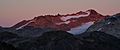
Kololo Peaks alpenglow
