Kurbat Ivanov facts for kids
Kurbat Afanasyevich Ivanov was a famous Cossack explorer of Siberia. He was the first Russian to discover Lake Baikal. He also created the first map of the Russian Far East. Kurbat Ivanov is also known for making an early map of the Chukotka region and the Bering Strait. This map was the first to show, even if roughly, lands like Wrangel Island, the Diomede Islands, and Alaska, which were not yet fully explored by Russians. He died in 1666.
Contents
Early Life and First Maps
Kurbat Ivanov was born a Yeniseyan Cossack. In 1642, he created the first map of the Russian Far East. This map was based on the explorations done by Ivan Moskvitin.
Journey to Lake Baikal
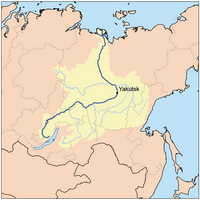
In 1643, Kurbat Ivanov arrived at the Verkholensky ostrog. An ostrog was a type of Russian fort or settlement. This fort was located on the Lena River. On June 21, 1643, he set out with 74 men. They sailed south up the Lena River. Ivanov wanted to find out if rumors of a large lake south of the Lena were true. He took a local leader, a Tungus prince named Mozheul, to help guide them.
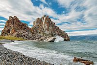
They traveled through the upper Lena River and its branch, the Ilikta. They then reached the Primorsky Ridge. They crossed this ridge on foot. From there, they went down the Sarma River to Lake Baikal. They arrived near Olkhon Island. After building new boats, Ivanov sailed to Olkhon Island.
Exploring Baikal's Shores
Kurbat Ivanov sent 36 men to explore more of Lake Baikal. They were led by Semyon Skorokhodov. They sailed along the western shore of Baikal. Their goal was to reach the mouth of the Upper Angara river. Another Tungus prince, named Yunoga, helped them.
Skorokhodov reached the northern tip of Baikal. There, they built a winter camp. They began collecting tribute, which was a type of tax or payment, from the local people. In late 1643, Skorokhodov was returning south with half of his men. However, they were attacked by a group led by Arkhich Batur, likely a Buryat. Skorokhodov and some of his men were killed. Twelve men managed to return to the Verkholensky ostrog. Two other men, Lyovka Vyatchanin and Maximka Vyzhegchanin, traveled even further. They reached the Yeniseysky ostrog by following the Angara and Yenisey rivers. Maximka Vyzhegchanin later returned to Baikal with another leader, ataman V. Kolesnikov.
Kurbat Ivanov himself safely returned to the Verkholensky ostrog. He used the same route he had taken to reach Baikal. He created an important document called "The Chart of Baikal and into Baikal flowing rivers and lands…" This chart was a map and description of the area. Ivanov shared stories about the many fish in Baikal. He also spoke of the many fur-bearing animals on its shores. Because of his discoveries, many Cossacks later traveled to Baikal using the path he had explored.
Mapping Chukotka and Alaska
At another point in his life, Ivanov worked on the lower Lena River in Zhigansk. From 1659 to 1665, he served in the Anadyrsky ostrog. He was the leader of Anadyrsk after Semyon Dezhnyov. In 1660, he sailed from the Anadyr Bay to Cape Dezhnyov.
Based on his own journeys and the explorations of Dezhnyov and Popov, Kurbat Ivanov created a map. He also gathered stories from local people. This map showed the Chukotka and the Bering Strait. It was the first map to show lands that were not yet fully discovered by Russians. These included Wrangel Island, both Diomede Islands, and even Alaska.
However, these lands, except for the Chukotka coastline, were shown very roughly. This suggests that Ivanov or other Russians had not visited or clearly seen them before. Alaska was first clearly seen and documented in 1732. This happened during an expedition led by Ivan Fyodorov and Mikhail Gvozdev. Wrangel Island was discovered much later.
See also
 In Spanish: Kurbat Ivanov para niños
 | Victor J. Glover |
 | Yvonne Cagle |
 | Jeanette Epps |
 | Bernard A. Harris Jr. |


