
Yenisey facts for kids
Quick facts for kids Yenisei |
|
|---|---|

The confluence of the rivers Kaa-Khem and Piy-Khem near Kyzyl
|
|

The Yenisey basin, including Lake Baikal
|
|
| Country | Mongolia, Russia |
| Region | Tuva, Krasnoyarsk Krai, Khakassia, Irkutsk Oblast, Buryatia, Zabaykalsky Krai |
| Cities | Kyzyl, Shagonar, Sayanogorsk, Abakan, Divnogorsk, Krasnoyarsk, Yeniseysk, Lesosibirsk, Igarka, Dudinka |
| Physical characteristics | |
| Main source | Mungaragiyn-Gol ridge Dod-Taygasyn-Noroo, Mongolia 3,351 m (10,994 ft) 50°43′46″N 98°39′49″E / 50.72944°N 98.66361°E |
| 2nd source | The most distant source: Yenisey-Angara-Selenga-Ider system Khangai Mountains 2,850 m (9,350 ft) 47°54′47″N 97°57′1″E / 47.91306°N 97.95028°E |
| River mouth | Yenisey Gulf Arctic Ocean, Russia 71°50′0″N 82°40′0″E / 71.83333°N 82.66667°E |
| Length | 3,487 km (2,167 mi) |
| Width |
|
| Depth |
|
| Discharge (location 2) |
|
| Discharge (location 3) |
(Period of data: 1940-2017) 588 km3/a (18,600 m3/s) 620 km3/a (20,000 m3/s)
|
| Basin features | |
| Basin size | 2,554,482 km2 (986,291 sq mi) to 2,580,000 km2 (1,000,000 sq mi) |
| Tributaries |
|
The Yenisey River is one of the longest rivers in the world. It is the largest river system that flows into the Arctic Ocean. The Yenisey is also known as Yenisei or Jenisej.
This mighty river starts in Mongolia. It flows north through Lake Baikal and past the Krasnoyarsk Dam. Finally, it empties into the Yenisey Gulf in the Kara Sea. The Yenisey acts like a natural border. It separates the Western Siberian Plain in the west from the Central Siberian Plateau in the east. It drains a huge part of central Siberia.
The Yenisey is one of three big Siberian rivers that flow into the Arctic Ocean. The other two are the Ob and the Lena. The Yenisey can be very deep, reaching about 217 feet (66 m). Its average depth is around 46 feet (14 m).
Contents
Yenisey River: A Journey Through Siberia

The Yenisey River itself is about 3,487 km (2,167 mi) long. This length is measured from where its two main source rivers, the Great Yenisey and Little Yenisey, meet at Kyzyl. It flows all the way to its mouth in the Kara Sea. If you measure from its farthest source, the Selenga tributary, the river system is about 5,075 km (3,153 mi) long.
The area of land that drains into the Yenisey is huge, covering about 2,580,000 km2 (1,000,000 sq mi). The river flows through several parts of Russia. These include Tuva, Khakassia, and Krasnoyarsk Krai. The large city of Krasnoyarsk is located right on the Yenisey.
Rivers Joining the Yenisey
Many smaller rivers flow into the Yenisey. These are called tributaries. Here are some of the biggest ones, listed from the start of the Yenisey to its end:
- Little Yenisey (from the left)
- Great Yenisey (from the right)
- Khemchik (left)
- Kantegir (left)
- Abakan (left)
- Tuba (right)
- Mana (right)
- Bazaikha (right)
- Kacha (left)
- Kan (right)
- Angara (right)
- Kem (left)
- Bolshoy Pit (right)
- Sym (left)
- Dubches (left)
- Podkamennaya Tunguska (right)
- Bakhta (right)
- Yeloguy (left)
- Nizhnyaya Tunguska (right)
- Turukhan (left)
- Kureyka (right)
- Khantayka (right)
- Bolshaya Kheta (left)
- Tanama (left)
Lake Baikal: A Deep and Ancient Lake
One very important part of the Upper Yenisey region is Lake Baikal. This lake is known for being the deepest and oldest lake in the entire world.

Brekhovskie Islands: Home for Birds
The Brekhovskie Islands are found where the Yenisey River meets the sea. These islands cover a huge area, about 1.4 million hectares. They are a special wetland area for many rare and endangered birds. These islands are an important place for many types of waterfowl to nest and raise their young.
Wildlife of the Yenisey Basin
The Yenisey basin is home to 55 types of native fish. This includes two types found nowhere else in the world. Most fish here are common in Siberia and Europe. Examples include northern pike, common roach, and European perch.
Many types of salmonids also live here. These include trout, whitefish, charr, and graylings. The Siberian sturgeon is another important fish species found in the basin.
The Yenisey valley is also rich in plants and animals. You can find Siberian pine and Siberian larch trees here. Long ago, around 6000 BC, Scots pine trees were very common in the valley. Many bird species live in this area too, such as the hooded crow.
Taimyr Reindeer Herd: The World's Largest
The Taimyr herd is the biggest group of tundra reindeer in the world. These reindeer travel to areas along the Yenisey for winter grazing. In 2010, there were an estimated 800,000 to 850,000 reindeer in this herd. At its peak, the herd had over one million individuals.

River steamers first came to the Yenisey River in 1864. They were brought from Holland and England across the icy Kara Sea. One famous ship was the SS Nikolai. Another, the SS Thames, tried to explore the river but was damaged by ice in 1876.
Russian leaders wanted to use river steamers to connect with Siberia. One boat, the SS St. Nicholas, carried the future Tsar Nicholas II on his trip to Siberia. Later, it even took Vladimir Lenin to prison.
Engineers tried to use river steamers regularly when building the Trans-Siberian Railway. The boats were needed to bring in rails, engines, and supplies. However, the sea and river route was very difficult. Many ships were lost at sea or on the river. The mouths of the Ob and Yenisey rivers are long, shallow, and often covered in ice. They also have strong winds, making them dangerous for ships. After the railway was finished, river traffic became mostly local. The Arctic route was too long and indirect.
In September 2001, an Australian-Canadian team became the first to travel the entire length of the Yenisey. This included its wild upper part in Mongolia. The team members were Ben Kozel, Tim Cope, Colin Angus, and Remy Quinter. Both Kozel and Angus wrote books about their amazing journey. A documentary was also made for National Geographic Television.
A special canal inclined plane was built on the river in 1985. It helps boats move past the Krasnoyarsk Dam.
History of the Yenisey Region
For a very long time, nomadic tribes like the Ket people and the Yugh people have lived along the Yenisey River. This area is where the Yeniseian language family comes from. Today, only about 1000 Ket people remain. They are the last survivors of the groups who once lived all over central southern Siberia near the river. Their relatives, like the Kotts and Arins, are now extinct. The modern Ket people lived in the middle parts of the river. They became part of Russia between the 17th and 19th centuries.
Some of the earliest signs of Turkic origins were found in the Yenisey Valley. These include stone monoliths and memorial tablets from the 7th to 9th centuries AD. Documents found in China's Xinjiang region also tell us about battles between the Turks and the Chinese. There are also examples of Uyghur poetry, mostly known through Chinese translations.
During World War II, Nazi Germany and the Japanese Empire planned to divide Asia. Their agreed border followed the Yenisey River to the border of China and the Soviet Union.
Environmental Care
Studies have shown that the Yenisey River has faced environmental challenges. This is due to past activities from a factory in the city of Zheleznogorsk (once known as Krasnoyarsk-26). It's important to protect our rivers and ensure they stay clean for everyone.
Images for kids
-
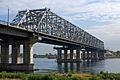
The bridge over the Yenisey in Krasnoyarsk, Russia, viewed from the left bank.
-
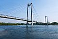
Vinogradovsky Most, the bridge in Krasnoyarsk, Russia, viewed from the left bank
-
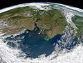
The Yenisey (left) and the Ob flow into Kara Sea (south at top in this view).


See also
 In Spanish: Río Yeniséi para niños
- List of rivers of Russia
- Sayano-Shushenskaya Dam
- Yenisey Range
