Lāʻie, Hawaii facts for kids
Quick facts for kids
Laie
Lāʻie
|
|
|---|---|

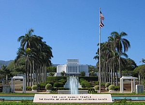
The Laie Hawaii Temple, the fifth oldest LDS Church temple worldwide
|
|

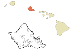
Location in Honolulu County and the state of Hawaii
|
|
| Country | United States |
| State | Hawaii |
| Area | |
| • Total | 2.17 sq mi (5.62 km2) |
| • Land | 1.34 sq mi (3.47 km2) |
| • Water | 0.83 sq mi (2.16 km2) |
| Elevation | 9 ft (3 m) |
| Population
(2020)
|
|
| • Total | 5,963 |
| • Density | 4,453.32/sq mi (1,719.63/km2) |
| Time zone | UTC−10 (Hawaii-Aleutian) |
| ZIP Code |
96762
|
| Area code(s) | 808 |
| FIPS code | 15-43250 |
| GNIS feature ID | 0361691 |
Laie (Hawaiian: Lāʻie, pronounced laa-EE-eh) is a special community in Honolulu County, Hawaii, United States. It's located on the island of Oahu (Oʻahu). The name Lāʻie in Hawaiian means "ʻie leaf." The ʻieʻie is a climbing plant that looks like a screwpine. In 2020, about 5,963 people lived here.
Contents
History of Laie
Historically, Lāʻie was a very important place called a puʻuhonua. This means it was a "city of refuge" or a sanctuary. If someone was in trouble or being chased, they could find safety here. It was against the rules to harm anyone once they reached the puʻuhonua.
During times of war, white flags were put up at the edges of the city. This showed everyone that it was a safe zone. People who found refuge here were protected. They could stay for a while, sometimes even for years. After a certain time, they could choose to help the priests of the sanctuary or leave freely. These traditional cities of refuge stopped being used in 1819.
The name Lāʻie comes from two Hawaiian words: lau (meaning "leaf") and ʻie (referring to the ʻieʻie plant). This plant is a red-spiked climbing screwpine that grows in the forests behind Lāʻie. In Hawaiian stories, this plant is special to Kāne, the god of the earth and forests. It's also sacred to Laka, the goddess of hula dancing.
The community of Lāʻie has always been connected to nature. It was known as a place of safety and life. Long ago, there were at least two traditional Hawaiian temples, called heiau, in Lāʻie. Today, only small parts of them remain.
Land Changes in Laie
Between 1846 and 1848, the way land was owned in Hawaii changed a lot. This big change was called the [[Great Mahele|Great Mahele]]. Before this, the king and his chiefs owned most of the land. After the Mahele, land was divided differently. The king kept some land, the chiefs got some, and some became government land.
The land was divided into sections called ahupuaʻa. These sections were shaped like a slice of pie. The tip was in the mountains, the middle was in the foothills, and the wide part was along the ocean. Each ahupuaʻa had its own resources, from the mountains to the sea. The village of Lāʻie is located within the ahupuaʻa of Lāʻie. This area had many streams, which were important for growing crops.
Latter-day Saints in Laie
A new chapter for Lāʻie began in 1865. The LDS Church bought a large sugar plantation here. Members of the church in Hawaii were encouraged to move to Lāʻie.
A sugar factory was built, and much of the land was used for growing sugarcane. However, people also grew other important food crops. It was special because both sugar and kalo (taro, a starchy root) were grown at the same time. This was unusual because both crops need a lot of water. The Hawaiian workers were very dedicated to growing kalo, which was a main food for them. They even insisted that Saturdays be a non-work day so they could make poi for their families. Over the years, schools and church buildings were also built in the town.
In 1919, the LDS Church's main office for Hawaii moved to Honolulu. But by then, the Laie Hawaii Temple had been built in Lāʻie. This made Lāʻie the spiritual heart of the Latter-day Saint community in Hawaii.
Community Life in Laie
Lāʻie is well-known as a community with a strong connection to the LDS Church. It is home to the Laie Hawaii Temple, which is the church's fifth oldest working temple in the world.
Brigham Young University–Hawaii (BYU–Hawaii) is also located in Lāʻie. This university brings many students from around the world to the community.
Another famous place is the Polynesian Cultural Center (PCC). It's the largest living museum in Hawaii and attracts millions of visitors each year. The PCC has 42 acres of beautiful gardens and water features. It also has six small "villages" that show the different cultures and traditions of the Pacific islands. Visitors can enjoy family-friendly games, shows, and traditional Hawaiian feasts called luau.
In 2015, the PCC opened the Hukilau Marketplace. This area looks like Hawaii in the 1950s. It offers old-fashioned food, local products, and a friendly atmosphere. Also in 2015, a new hotel, the "Laie Courtyard by Marriott," opened. It has 144 rooms and replaced the old Laie Inn.
Even though Lāʻie is a small town, it has had a big influence on Hawaiian culture. Many people living here have family roots from other Pacific Island countries like Tonga, Samoa, Fiji, and New Zealand. In the late 1940s, community fishing events and feasts on the beach inspired a famous song called "The Hukilau Song."
Geography of Laie
Lāʻie is located at 21°38′55″N 157°55′32″W / 21.64861°N 157.92556°W. It is north of Hauula and south of Kahuku. The main road through town is Kamehameha Highway.
The area of Lāʻie is about 2.1 square miles (5.4 square kilometers). About 1.3 square miles (3.4 square kilometers) is land, and 0.9 square miles (2.3 square kilometers) is water.
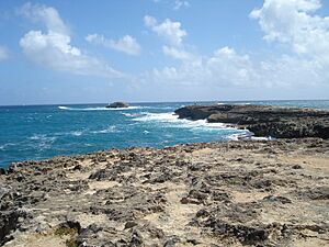
A special feature of the coastline is Lāʻie Point. This is a rocky dune that sticks out into the ocean. Two other rocky dunes, Kukuihoolua and Mokualai, are small islands just off the point.
To the south of town is Lāʻielohelohe Beach Park. This park includes Pahumoa Beach, named after Pahumoa "John" Kamakeʻeʻāina. He was a fisherman from Lāʻie who was known for sharing his fish with everyone in the village. He often led hukilau, which is a traditional way of community net fishing.
Pahumoa Beach was also known as Pounders Beach. This name became popular in the 1950s because of the strong waves that were great for bodysurfing. In 2021, the beach's official name was changed back to Pahumoa. Another popular bodysurfing beach is Hukilau, located at the north end of town.
Population and People
| Historical population | |||
|---|---|---|---|
| Census | Pop. | %± | |
| 2000 | 4,585 | — | |
| 2010 | 6,138 | 33.9% | |
| 2020 | 5,963 | −2.9% | |
| U.S. Decennial Census | |||
In 2000, there were 4,585 people living in Lāʻie. The population density was about 3,601 people per square mile. The community is very diverse. About 37% of the people were Pacific Islander, 28% were White, and 9% were Asian. About 25% of the people were from two or more races.
Many households in Lāʻie have children. In 2000, about 46% of households had children under 18. The average household size was 4.47 people, which is larger than many other places. The median age in Lāʻie was 24 years old, showing that it is a young community.
Education in Laie
The schools in Lāʻie are part of the Hawaii Department of Education. Students attend Lāʻie Elementary School. After elementary school, they go to Kahuku High & Intermediate School.
As mentioned earlier, Brigham Young University–Hawaii is also located in Lāʻie.
Notable People from Laie
Many interesting people have come from Lāʻie, including:
- Robert Anae (born 1958), a football coach.
- Eni Faleomavaega (1943–2017), a former politician from American Samoa.
- Joseph Kekuku (1874–1931), who invented the steel guitar.
- Neff Maiava (1924–2018), a professional wrestler.
- Ken Niumatalolo (born 1965), a former head football coach for the United States Naval Academy.
- Roman Salanoa (born 1997), a rugby player.
- Keala Settle (born 1975), an actress and singer.
- Manti Te'o (born 1991), an American football linebacker.
See also
In Spanish: Laie para niños
 | Jackie Robinson |
 | Jack Johnson |
 | Althea Gibson |
 | Arthur Ashe |
 | Muhammad Ali |


