
La Bohn Peak facts for kids
Quick facts for kids La Bohn Peak |
|
|---|---|
.jpg)
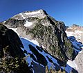
West aspect seen in winter
|
|
| Highest point | |
| Elevation | 6,585 ft (2,007 m) |
| Prominence | 705 ft (215 m) |
| Isolation | 1.8 mi (2.9 km) |
| Parent peak | Mount Hinman (7,500 ft) |
| Geography | |

La Bohn Peak
Location in Washington (state)

La Bohn Peak
Location in the United States
|
|
| Location | Alpine Lakes Wilderness King County, Washington state, U.S. |
| Parent range | Cascade Range |
| Topo map | USGS Mount Daniel |
| Climbing | |
| Easiest route | class 2 hiking East Ridge |
La Bohn Peak is a mountain peak in Washington state. It stands about 6,585 feet (2,007 meters) tall. You can find it in east King County, about two miles north of Dutch Miller Gap.
This peak is located in the beautiful Alpine Lakes Wilderness. It's part of the Mount Baker-Snoqualmie National Forest. La Bohn Peak is west of La Bohn Lakes and La Bohn Gap. It's also about one mile west of the main Cascade Range mountains.
Water from the south side of the mountain flows into the Snoqualmie River. Water from the north side goes into the Foss River. The closest taller mountain is Mount Hinman, which is about 1.7 miles (2.7 km) to the east.
Mountain Weather
La Bohn Peak is in a marine west coast climate zone. This means it gets a lot of rain and snow. Most of the weather comes from the Pacific Ocean. These weather systems move northeast towards the Cascade Range.
When the air hits the tall Cascade Mountains, it is forced to rise. As it rises, it cools down and drops its moisture. This process is called Orographic lift. It causes a lot of rain or snow to fall on the western side of the mountains.
During winter, there is often heavy snowfall. This snow can be wet and heavy, which can cause avalanches. Summers are usually clearer and sunnier. The best time to visit or climb La Bohn Peak is from July to September.
How the Mountains Formed
The Alpine Lakes Wilderness has very rugged land. You can see jagged peaks, deep valleys carved by glaciers, and tall granite walls. There are also over 700 mountain lakes in this area.
The different shapes of the land were created over millions of years. This happened because of big geological events. These events also led to different climates and types of plants. The land here ranges from about 1,000 feet (300 meters) to over 9,000 feet (2,700 meters) high.
The Cascade Range started forming millions of years ago. This was during the late Eocene Epoch. The North American Plate slowly moved over the Pacific Plate. This caused many volcanic eruptions. Also, small pieces of the Earth's crust, called terranes, helped build the North Cascades about 50 million years ago.
Later, during the Pleistocene period (over two million years ago), glaciers played a big role. Huge sheets of ice moved across the land many times. They carved out the landscape and left behind rock debris. The last glaciers in the Alpine Lakes area started melting about 14,000 years ago.
The river valleys in this area have a U-shape. This shape was created by these recent glaciers. The mountains became tall and the valleys deep because of a mix of uplift (when land pushes up) and faulting (when cracks form in the Earth's crust). Glaciation also helped shape this amazing landscape.
Images for kids
-
Northeast aspect

