La Crosse, Kansas facts for kids
Quick facts for kids
La Crosse, Kansas
|
|
|---|---|
|
City and County seat
|
|

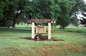
Welcome Sign (2010)
|
|

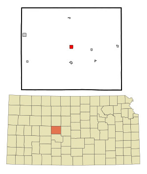
Location within Rush County and Kansas
|
|

|
|
| Country | United States |
| State | Kansas |
| County | Rush |
| Founded | 1876 |
| Incorporated | 1886 |
| Named for | La Crosse, Wisconsin |
| Area | |
| • Total | 1.04 sq mi (2.68 km2) |
| • Land | 1.04 sq mi (2.68 km2) |
| • Water | 0.00 sq mi (0.00 km2) |
| Elevation | 2,057 ft (627 m) |
| Population
(2020)
|
|
| • Total | 1,266 |
| • Density | 1,217/sq mi (472.4/km2) |
| Time zone | UTC-6 (CST) |
| • Summer (DST) | UTC-5 (CDT) |
| ZIP codes |
67548, 67553
|
| Area code | 785 |
| FIPS code | 20-37500 |
| GNIS ID | 2395563 |
La Crosse is a city in Kansas, USA. It's the main town, or county seat, of Rush County. As of the 2020 census, about 1,266 people lived there. La Crosse is famous for calling itself the "Barbed Wire Capital of the World"!
Contents
History of La Crosse
La Crosse was started in 1876. It was named after a city in Wisconsin, also called La Crosse. The town quickly became the planned county seat. This meant it would be the center for county government.
County records were moved here from Rush Center. This caused a "county seat war" between the two towns. This fight lasted until 1888. That's when La Crosse was officially named the permanent county seat. A new courthouse was built there.
In the 1960s, La Crosse became a big center for collecting barbed wire. This led to the creation of the Kansas Barbed Wire Museum. Because of this, the city earned its nickname: "The Barbed Wire Capital of the World".
Tornado of 2012
On May 25, 2012, a strong storm hit La Crosse. An EF-1 tornado caused a lot of damage. About four blocks of the city were badly affected. Two businesses were completely destroyed. Many other businesses had major damage. Luckily, no one was hurt during the tornado.
Geography and Location
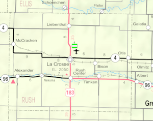
La Crosse is in the Smoky Hills area of the Great Plains. It's about 12 miles (19 km) south of the Smoky Hill River. It's also about 5 miles (8 km) north of Walnut Creek. Walnut Creek is a smaller river that flows into the Arkansas River.
Smaller streams like Sand Creek and Mule Creek flow near and through the city. La Crosse is in west-central Kansas. It sits where U.S. Route 183 and K-4 highways meet. The city covers about 1.05 square miles (2.72 km2) of land.
Climate in La Crosse
La Crosse has a varied climate. July is usually the hottest month of the year. January is typically the coldest month. May is often the wettest month, with the most rain.
The highest temperature ever recorded was 115 °F (46 °C) in 1954. The lowest temperature ever recorded was -24 °F (-31 °C) in 1989.
| Climate data for La Crosse, Kansas | |||||||||||||
|---|---|---|---|---|---|---|---|---|---|---|---|---|---|
| Month | Jan | Feb | Mar | Apr | May | Jun | Jul | Aug | Sep | Oct | Nov | Dec | Year |
| Record high °F (°C) | 81 (27) |
86 (30) |
95 (35) |
103 (39) |
107 (42) |
112 (44) |
115 (46) |
114 (46) |
112 (44) |
100 (38) |
89 (32) |
83 (28) |
115 (46) |
| Mean daily maximum °F (°C) | 41 (5) |
47 (8) |
57 (14) |
67 (19) |
76 (24) |
87 (31) |
94 (34) |
92 (33) |
83 (28) |
72 (22) |
55 (13) |
44 (7) |
68 (20) |
| Mean daily minimum °F (°C) | 15 (−9) |
19 (−7) |
28 (−2) |
38 (3) |
50 (10) |
60 (16) |
65 (18) |
63 (17) |
54 (12) |
41 (5) |
27 (−3) |
19 (−7) |
40 (4) |
| Record low °F (°C) | −23 (−31) |
−17 (−27) |
−23 (−31) |
9 (−13) |
21 (−6) |
36 (2) |
43 (6) |
42 (6) |
23 (−5) |
14 (−10) |
−8 (−22) |
−24 (−31) |
−24 (−31) |
| Average precipitation inches (mm) | 0.66 (17) |
0.83 (21) |
2.09 (53) |
2.27 (58) |
3.65 (93) |
3.35 (85) |
3.40 (86) |
2.55 (65) |
1.88 (48) |
1.42 (36) |
1.22 (31) |
0.76 (19) |
24.08 (612) |
| Source: The Weather Channel | |||||||||||||
Population of La Crosse
| Historical population | |||
|---|---|---|---|
| Census | Pop. | %± | |
| 1890 | 513 | — | |
| 1900 | 536 | 4.5% | |
| 1910 | 806 | 50.4% | |
| 1920 | 808 | 0.2% | |
| 1930 | 1,355 | 67.7% | |
| 1940 | 1,407 | 3.8% | |
| 1950 | 1,769 | 25.7% | |
| 1960 | 1,767 | −0.1% | |
| 1970 | 1,583 | −10.4% | |
| 1980 | 1,618 | 2.2% | |
| 1990 | 1,427 | −11.8% | |
| 2000 | 1,376 | −3.6% | |
| 2010 | 1,342 | −2.5% | |
| 2020 | 1,266 | −5.7% | |
| U.S. Decennial Census | |||
2020 Census Information
The 2020 United States census counted 1,266 people in La Crosse. There were 547 households, which are groups of people living together. About 318 of these households were families.
About 22.1% of the people were under 18 years old. About 25.3% were 65 years or older. The average age in the city was 45.6 years.
2010 Census Information
In the census of 2010, there were 1,342 people living in La Crosse. There were 606 households. About 24.9% of these households had children under 18.
The average age in the city was 47.7 years. About 19.9% of people were under 18. About 26.9% were 65 or older.
Education in La Crosse
The local public school system is called La Crosse USD 395. It runs three schools right in the city:
- La Crosse High School (for grades 9-12)
- La Crosse Middle School (for grades 7-8)
- La Crosse Elementary School (for grades K-6)
Transportation Around La Crosse
U.S. Route 183 runs through La Crosse from north to south. It crosses Kansas Highway 4 (K-4). K-4 runs east to west along the northern edge of the city.
The Rush County Airport is located northeast of the city. It's on the north side of K-4. This airport is used for general aviation, which means private and smaller planes.
A train line from the Kansas and Oklahoma Railroad also passes through La Crosse. It runs from southeast to northwest.
Media in La Crosse
Print Media
The Rush County News is a newspaper published every week in La Crosse.
Radio Stations
Several radio stations broadcast from or are licensed to La Crosse:
| Frequency | Callsign | Format | City of License | Notes |
|---|---|---|---|---|
| 93.5 | KKDT | Adult Hits | Burdett, Kansas | "Dave FM"; Broadcasts from La Crosse |
| 104.7 | KXNC | Top 40 | Ness City, Kansas | Broadcasts from La Crosse |
Television
La Crosse is part of the Wichita-Hutchinson, Kansas television market. This means people in La Crosse get TV channels from these larger cities.
Culture and Fun in La Crosse
Events
- Rush County Fair: This is a popular event for the community.
Points of Interest
There are several interesting places to visit in La Crosse:
- Kansas Barbed Wire Museum: Learn all about barbed wire and its history.
- Post Rock Museum: See how early settlers used local stone for fences and buildings.
- Historical Museum: Discover more about the history of La Crosse and the surrounding area.
- Nekoma Bank Museum
- Pleasant Point One-Room School Museum: Experience what school was like long ago in a single classroom.
See also
 In Spanish: La Crosse (Kansas) para niños
 | Bayard Rustin |
 | Jeannette Carter |
 | Jeremiah A. Brown |

