La Vernia, Texas facts for kids
Quick facts for kids
La Vernia, Texas
|
|
|---|---|
|
City
|
|
 |
|
| Nickname(s):
L V, Bear Country
|
|
| Motto(s):
This is Bear Country
|
|

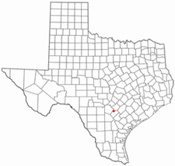
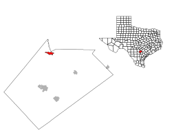
Location of La Vernia, Texas
|
|
 |
|
| Country | United States |
| State | Texas |
| County | Wilson |
| Area | |
| • Total | 2.39 sq mi (6.20 km2) |
| • Land | 2.39 sq mi (6.19 km2) |
| • Water | 0.00 sq mi (0.01 km2) |
| Elevation | 495 ft (151 m) |
| Population
(2020)
|
|
| • Total | 1,077 |
| • Density | 597.74/sq mi (230.77/km2) |
| Time zone | UTC−6 (Central (CST)) |
| • Summer (DST) | UTC−5 (CDT) |
| ZIP code |
78121
|
| Area code(s) | 830 |
| FIPS code | 48-41764 |
| GNIS feature ID | 2411585 |
| Website | lavernia-tx.gov |
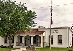
La Vernia is a city in Wilson County, Texas, United States. It is located on the south bank of Cibolo Creek, where U.S. Highway 87 and Texas Farm to Market Road 775 meet. This small city is about 25 miles east of downtown San Antonio. In 2020, about 1,077 people lived here. La Vernia is part of the larger San Antonio metropolitan area.
Contents
History of La Vernia
The area where La Vernia is located was first home to the Coahuiltecan people. Later, Apache and Comanche groups also lived here. One of the first land grants was given to Erastus "Deaf" Smith in 1825. He received this land from the Mexican government on Cibolo Creek.
European settlers began to arrive in 1837, especially veterans from the Texas Revolution. La Vernia was truly settled around 1850. W. R. Wiseman from Mississippi started a Presbyterian church here in 1851. He is believed to have named the place Live Oak Grove because of the many oak trees nearby.
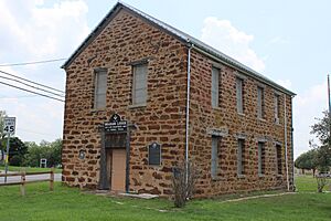
In 1853, a post office was opened, and the town was called Post Oak. The town's name changed to La Vernia in 1859. This name came from the local Spanish words for "green oaks." The Brahan Masonic lodge was also built in 1859. This building was used as a school and a church too.
Many German and Polish immigrants moved to La Vernia, and by 1885, the population grew to 110 people. The community had three churches, a steam gristmill (for grinding grain), and a cotton gin (for separating cotton fibers). Farmers mainly grew corn and cotton, which are still important crops today.
By 1890, La Vernia had 200 residents. When the San Antonio and Gulf Railroad was built through the area in 1893, the population increased to 343 by 1900. A school with two teachers was open by 1896. Classes became so big that they had to move out of the Masonic lodge. The school had 66 students.
By 1915, the town had two cotton gins, a bank, four churches, a pottery plant, and a brick works. The population reached 500. In 1947, there were seventeen businesses. By 1965, the population grew to 700 residents and twenty-five businesses.
The community officially became a city around 1966. In 1990, it had 639 people and thirty-six businesses. La Vernia's population dropped a bit as people moved to bigger cities like San Antonio, Floresville, and Canyon Lake for more job opportunities.
In 2000, La Vernia had 136 businesses and 931 people. By 2005, the population was 1,087. In 2010, a new shopping area was built west of town on Highway 87. This included a new H-E-B grocery store and gas station. A long-time local grocery store, Baumann's Grocery, closed when H-E-B opened.
Geography
La Vernia covers about 2.4 square miles (6.2 square kilometers) of land.
Population Information
| Historical population | |||
|---|---|---|---|
| Census | Pop. | %± | |
| 1970 | 425 | — | |
| 1980 | 632 | 48.7% | |
| 1990 | 639 | 1.1% | |
| 2000 | 931 | 45.7% | |
| 2010 | 1,034 | 11.1% | |
| 2020 | 1,077 | 4.2% | |
| U.S. Decennial Census | |||
| Race | Number | Percentage |
|---|---|---|
| White (NH) | 735 | 68.25% |
| Black or African American (NH) | 3 | 0.28% |
| Native American or Alaska Native (NH) | 4 | 0.37% |
| Asian (NH) | 8 | 0.74% |
| Some Other Race (NH) | 6 | 0.56% |
| Mixed/Multi-Racial (NH) | 24 | 2.23% |
| Hispanic or Latino | 297 | 27.58% |
| Total | 1,077 |
In 2020, there were 1,077 people living in La Vernia. There were 348 households and 233 families.
In 2000, there were 931 people, 317 households, and 239 families. About 40.1% of households had children under 18. The average household had 2.65 people, and the average family had 3.08 people.
The population was spread out by age. About 25.1% were under 18, and 23.5% were 65 or older. The average age was 40 years old.
Education
The La Vernia Independent School District provides public education for students in La Vernia. It has a total of 3,182 students.
- La Vernia Primary School teaches students from pre-kindergarten to third grade.
- Intermediate School opened in 2009 and serves grades three to five.
- The building that is now the junior high was the first school building for the district. It used to serve all grades but now teaches sixth, seventh, and eighth grades.
- La Vernia High School includes grades nine to twelve.
For private school education, students can attend the La Vernia Christian Teaching Center.
Economy
La Vernia is located in the middle of the Eagle Ford Shale Play. This area is important for producing petroleum (oil) and natural gas. This production helps the economy grow in South Texas.
The biggest employers in La Vernia are the La Vernia Independent School District and Guadalupe Valley Electric Cooperative. Many people work in retail, and the largest employer in that area is the grocery store H-E-B.
Culture
The La Vernia Heritage Museum shows old items and memories that tell the story of the city's history and how it grew.
Sports
La Vernia High School has many sports teams for students.
- Girls' teams compete in basketball, softball, soccer, cheerleading, track & field, tennis, volleyball, and golf.
- Boys' teams compete in football, baseball, basketball, soccer, track & field, tennis, wrestling, and golf.
Younger kids can join La Vernia Little League, which has baseball and softball teams for ages 4 to 16.
Notable people
- Dusty Jonas, Olympic high jumper
- Austin Mahone, pop singer
- Jane Y. McCallum, Texas Secretary of State
- Hugh M. Tiner, the second president of Pepperdine University
See also
 In Spanish: La Vernia para niños
 | Ernest Everett Just |
 | Mary Jackson |
 | Emmett Chappelle |
 | Marie Maynard Daly |


