
Cibolo Creek facts for kids
Quick facts for kids Cibolo Creek |
|
|---|---|

Cibolo Creek in Boerne
|
|

Map of the Cibolo Creek watershed
|
|
| Country | United States |
| State | Texas |
| Physical characteristics | |
| Main source | Turkey Knob Boerne, Texas 623 m (2,044 ft) 29°50′18″N 98°53′10″W / 29.83833°N 98.88611°W |
| River mouth | San Antonio River Helena, Texas 93 m (305 ft) 28°57′11″N 97°52′24″W / 28.95306°N 97.87333°W |
| Length | 154.497 km (96.000 mi) |
Cibolo Creek is a stream in South Central Texas that flows for about 96 miles (154 km). It starts at a place called Turkey Knob near Boerne, Texas, in the Texas Hill Country. The creek then flows southeast until it joins the San Antonio River in Karnes County, Texas. It's like a smaller river that feeds into a bigger one.
This creek is important for many reasons. People use it for fun activities like fishing and kayaking. It also forms the eastern border of Bexar County, Texas. Many different types of fish and other animals live in and around the creek. You can find several parks along its banks, including Cibolo Nature Center. Many towns have grown up along the creek, such as Boerne, Fair Oaks Ranch, San Antonio, Bulverde, Schertz, Universal City, and Cibolo.
Contents
Cibolo Creek's Journey
Cibolo Creek begins its journey in the Texas Hill Country, northwest of Boerne, Texas. As it flows southeast towards the San Antonio River, about 30 cubic feet (850 liters) of water pass by every second. The upper part of the creek is known for being very beautiful, with steady water flowing through deep canyons and over rocky areas, forming small waterfalls.
Before it reaches Boerne, the creek is dammed to create Boerne City Lake. This lake provides drinking water for the people living in Boerne. In town, the creek flows right through the middle before reaching the Cibolo Nature Center. This center is famous for its shores lined with tall bald cypress trees. East of the nature center, the creek enters the Cibolo Canyonlands, where the canyons get even deeper. Here, water from the creek helps refill underground water sources. Some of this area is protected by the University of Texas at San Antonio for environmental research.
Further downstream, the creek goes through Fair Oaks Ranch and Bulverde. In some spots, especially near Camp Bullis in northern San Antonio, the water flow can slow down or even dry up, showing the rocky bottom. These dry spots continue as the creek forms the border between Bexar and Comal Counties. The water flow picks up again where Bexar and Guadalupe Counties meet, and the creek passes by Randolph Air Force Base.
As the creek reaches its lower parts, the land becomes flatter and less rocky. Here, you'll see trees like oak, mesquite, and juniper. The Cibolo Creek winds through Wilson and Karnes Counties, passing towns like Zuehl, New Berlin, and Sutherland Springs. Finally, it meets the San Antonio River near the old ghost town of Helena.
-
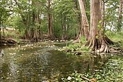
Cibolo Creek at Cibolo Nature Center
-
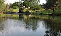
Cibolo Creek in Boerne, Texas
-
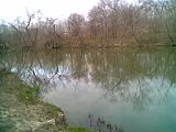
Cibolo Creek in Universal City, Texas
-
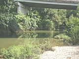
Cibolo Creek at IH-10 near Zuehl, Texas


Cibolo Creek's Watershed
The drainage basin (the area of land where all the water drains into the creek) of Cibolo Creek is located in a special geological area. Many springs in the upper and middle parts of the watershed have karst activity. This means water dissolves the limestone underground, forming caves like Cascade Caverns and Natural Bridge Caverns. Water from the creek and these underground springs helps to refill the Edwards-Trinity aquifer system. This important underground water system provides drinking water for millions of people in the area.
Near where the water refills the aquifer, parts of the creek have carved deep canyons into the landscape of the Texas Hill Country. This area is known as the Cibolo Canyonlands. The Cibolo Nature Center protects about 1,300 acres (5.3 km²) of this watershed. They work to keep the water clean, especially with more people moving into the area.
Several smaller streams flow into Cibolo Creek, making up its watershed. Balcones Creek, which is about 13 miles (21 km) long, is a main stream that joins Cibolo Creek where Bexar, Kendall, and Bandera Counties meet. Other streams that feed into Cibolo Creek include Martinez Creek and Santa Clara Creek.
Cibolo Creek's History

Before Europeans arrived, Native American tribes had different names for Cibolo Creek. The Coahuiltecan Indians called it Xoloton, and the Tonkawa tribe called it Bata Coniquiyoqui. Early Spanish explorers also gave it various names. The name Cibolo first appeared in 1721. Cibolo is a Spanish and Native American word for American bison, also known as buffalo. These large animals used to live in the area.
Native Americans are believed to have used the steep banks along the creek for hunting. They would chase herds of buffalo into the creek bed, where the animals would fall. This made hunting easier for them.

In 1734, a fort called El Fuerte de Santa Cruz del Cíbolo was built along the creek. Its purpose was to protect livestock from Apache attacks. This fort was rebuilt in 1771 but was later destroyed in 1782.
During the Texas Revolution, Cibolo Creek was the site of two small battles. In October 1835, at the start of the war, Texas scouts led by Captain Ben Milam encountered Mexican soldiers near the creek. The Texans fought bravely and forced the Mexicans to retreat. This small victory made the Texans feel more confident. Another skirmish happened in April 1836, when Juan Seguín and his men, who were looking for wild horses, met some Tonkawa Native Americans. After a brief fight, Seguín's group returned to their camp with more horses.
Also in 1836, during the famous Battle of the Alamo, Cibolo Creek was a temporary camp for forces trying to help the Alamo defenders. On February 28, some relief forces met near the Cibolo. On February 29, the Gonzales Company of Mounted Volunteers arrived at the Cibolo and entered the Alamo the next day. Later, on March 7, another group of 50 men tried to reach the Alamo but were stopped by Mexican cavalry.

In the mid-1800s, towns like Selma, Sutherland Springs, Boerne, and Bulverde were founded along the creek. Later, Cibolo, Schertz, and Universal City were also established. These communities often faced severe floods, which caused damage and loss. Big floods happened in October 1998 and July 2002. To help improve water quality, the San Antonio River Authority spent money in 2003 to clean up debris from the creek. There have been concerns about high levels of bacteria in some parts of the creek, leading to plans like the Upper Cibolo Watershed Protection plan, which started in 2010.
Fun Activities at Cibolo Creek
Many places along Cibolo Creek are set up for fun outdoor activities. Boerne City Park has trails for hiking, nature walks, and horseback riding. It's part of the larger Cibolo Nature Center. Camp Bullis, a military training area along the creek, allows hunting for deer and other animals, and has places for archery and fishing.
A section of the creek, about 18 miles (29 km) long, is known for whitewater rafting and kayaking. This area is also a popular spot for camping. You can also find a frisbee golf course at the Universal City Cibolo Creek Preserve area. Between Stockdale and Floresville, Cibolo Creek forms the eastern edge of Jackson Nature Park. This 50-acre (20 ha) public park has trails where you can see plants, animals, and interesting geology from South Central Texas.
If you like fishing, Cibolo Creek is a great place! According to Texas Parks and Wildlife, you can catch many types of fish here, including largemouth bass, bluegill, channel catfish, Rio Grande cichlid, longnose gar, and different kinds of sunfish.
Cibolo Creek's Climate
The weather in the Cibolo Creek area has hot, humid summers and generally mild to cool winters. This type of weather is called a humid subtropical climate. On climate maps, it's often shown as "Cfa."
See also
 In Spanish: Arroyo Cibolo para niños
