Lake Papaitonga facts for kids
Quick facts for kids Lake Papaitonga |
|
|---|---|
 |
|
| Location | Southern Manawatū-Whanganui region, North Island |
| Coordinates | 40°38′42″S 175°13′33″E / 40.6450°S 175.2259°E |
| Basin countries | New Zealand |
| Surface area | 61.8 ha (153 acres) |
| Average depth | 1 m (3.3 ft) |
| Islands | Motukiwi (Papaitonga) and Motungarara (Papawharangi) |
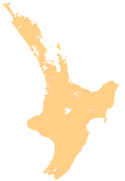
Lake Papaitonga is a special lake found in the Horowhenua area. This region is in the southern Manawatū-Whanganui area of New Zealand's North Island. The lake is part of the Papaitonga Scenic Reserve, a large area of forest and wetlands.
It is unique because it is the only lake in the Horowhenua region still surrounded by untouched native forest. It is also home to two groups of rare native land snails. For a long time, the Muaūpoko people lived around the lake. It was also a place where they faced a difficult time when chief Te Rauparaha arrived. Later, a naturalist named Walter Buller bought the land around the lake. He helped protect the forest, and eventually, it became a special scenic reserve.
What's in a Name?
Most people know this lake as Papaitonga. However, its original name is Waiwiri, which means "trembling waters." The name Papaitonga means "beauty of the south." This was actually the name of the largest island in the lake.
Over time, the name Papaitonga started being used for the whole scenic reserve around the lake. Eventually, it became the common name for the lake itself. Today, some people are starting to call it Lake Waiwiri again.
The names Motukiwi and Motungarara are often used for the islands Papaitonga and Papawharangi. But these are not traditional Māori names. Walter Buller made them up in the 1890s.
About Lake Papaitonga
The lake sits on a flat, sandy area in the Horowhenua. It is about 6 kilometres (3.7 miles) southwest of Levin. It is also about 5.9 kilometres (3.7 miles) from Hokio Beach on the Tasman Sea.
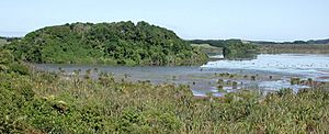
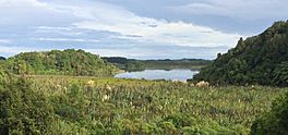
Lake Papaitonga covers about 61.8 hectares (152.7 acres). But it is quite shallow, less than 1 metre (3.3 feet) deep. Long ago, the lake was a sandy lagoon near the mouth of the Ohau River. The forested hills nearby were once sea cliffs. Over many years, sand dunes formed, the river changed its path, and the sea moved back. About 9,000 years ago, the lagoon became a lake when it was blocked by sand.
Today, the bottom of the lake has 15 metres (49 feet) of mud and silt over the original sand. This mud holds layers of volcanic ash from eruptions 8,000 and 5,900 years ago. The lake gets its water from underground sources and small streams. The Waiwiri Stream drains water out of the lake. Because it is surrounded by forest, the lake has low levels of nutrients like phosphorus and nitrogen. The lake was deeper until the 1940s. Now, with more farming and irrigation nearby, it is becoming shallower.
History of the Lake
Lake Papaitonga was once home to the Māori Muaūpoko iwi (tribe). They lived in villages around the lake. They gathered longfin and shortfin eels, waterfowl, and kākahi (freshwater mussels) from the wetlands. They also used the forest for its kiekie plants, which have sweet fruit.
The main island, Papaitonga (1.2 hectares or 3 acres), was cleared. It was planted with karaka trees. A smaller, man-made island, Papawharangi (0.3 hectares or 0.7 acres), was built in 1820. It was made from soil and mussel shells brought by canoes. Both islands were fortified to be used as pā (fortified villages) during times of conflict.
In 1822, Te Rauparaha and the Ngāti Toa tribe arrived in the area. At first, they were welcomed. But after a Muaūpoko woman was killed, Te Rauparaha's son and daughter were also killed. Te Rauparaha and his warriors sought revenge. They returned and fought the Muaūpoko people on Papaitonga Island. The Muaūpoko tribe was defeated and lost much of their land and influence. A hapū (sub-tribe) of Ngāti Raukawa then took over the lake. Since then, ownership of the lake has been debated by both tribes.
During the New Zealand Wars in the 1860s, the Muaūpoko sought justice. Their chief, Te Kēpa Te Rangihiwinui, was a war hero. He tried to keep Muaūpoko land, but disputes led to land being sold for railways and farms.
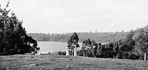
In 1891, a lawyer and bird expert named Walter Buller took the lake and 1,300 acres of land as payment for his legal work. Buller had always wanted Papaitonga. He thought it was "one of the prettiest bits of scenery in New Zealand."
Buller wanted to create a wildlife sanctuary and a country estate around the lake. He carefully protected the forest and wetlands. He also brought in different kinds of birds, both native and from other countries. Five white swans from Kew Gardens in England were released in 1893. He also changed the names of the two islands. Papaitonga became Motukiwi (kiwi island) because he released kiwi birds there. Papawharangi was renamed Motungarara (demon island) because he released tuatara there.
Buller also put up carved monuments, including a pataka (food storehouse). However, he was never able to build the big country home he wanted. He moved to England and died in 1906. His house at Papaitonga burned down in 1904.
In the early 1900s, Papaitonga was a popular place for recreation. In 1901, part of the forest was set aside to protect native trees. In 1903, a government committee decided to clear a space for picnics. In 1930, the forest became a scenic reserve. The government bought the lake from a Ngāti Raukawa farmer in 1981 and added it to the reserve.
Plants and Animals
The lake is surrounded on two sides by wetland forest. This forest has many kahikatea, pukatea, and swamp maire trees. There is also a lot of kiekie growing underneath. The drier forest on the higher land has tawa, kohekohe, and māhoe trees. Some rimu and tītoki trees are also found there. A rare plant called leafless mistletoe (Korthalsella salicornioides) grows in the manuka forest nearby.
The Papaitonga Scenic Reserve is very important for science. It has the last remaining example of wetland forest that gradually changes into dry forest in the Wellington and Horowhenua areas. The other sides of the lake are mostly farmland with few trees.
Lake Papaitonga has been a safe place for waterfowl for a long time. When Walter Buller lived there, up to 200 brown teal (which are now endangered) could be seen at once. Today, Black swan, shoveler, mallards, and dabchicks live on the lake. You can also see kingfishers, pukeko, harriers, kererū (New Zealand pigeons), and welcome swallows.
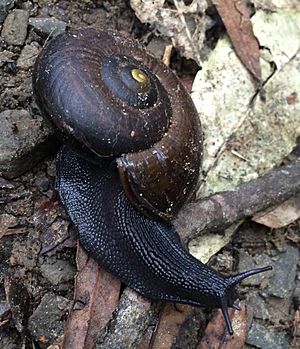
The northeastern part of Papaitonga Scenic Reserve is home to most of the world's population of an endangered land snail called Powelliphanta traversi traversi. These snails live in the damp, low-lying areas. This is one of only two places in the world where this snail lives. There is also another type of snail, P. t. florida, living on the southeastern side of the lake.
These native snails are in danger from rats, which eat many adult snails each year. Introduced birds like blackbirds and song thrushes also threaten them. The lake area is also slowly drying out because of drainage ditches, water bores, and farm irrigation.
The Department of Conservation (DOC) manages the reserve. They work to control possum and rat numbers. They have also banned dogs, hunting, and mountain biking in the reserve to protect the wildlife. In 2017, DOC caught an Australian water dragon that had been released into the reserve. Another one was seen a year later.
 | Janet Taylor Pickett |
 | Synthia Saint James |
 | Howardena Pindell |
 | Faith Ringgold |


