Lake Passaic facts for kids
Lake Passaic was a huge, ancient lake that formed in northern New Jersey at the end of the last ice age. This was about 19,000 to 14,000 years ago. The lake was created by water from the melting Wisconsin Glacier. This giant ice sheet had pushed a lot of earth and rocks in front of it. This blocked the old path of the Passaic River through the Watchung Mountains.
The lake stayed for thousands of years. As the ice melted and the natural dams of earth slowly wore away, the lake basin slowly drained. The creation of Lake Passaic changed the Passaic River's path forever. It forced the river to take a long, winding route through the northern Watchung Mountains.
Today, the area where the lake used to be is called Passaic Meadows. This includes places like the Great Swamp, Black Meadows, Troy Meadows, and Great Piece Meadows. These parts of the old lake are now important wetlands. They provide homes for many different plants and animals. They also offer fun outdoor activities for people in northern New Jersey.
Contents
How We Found Out About Lake Passaic
The discovery of Glacial Lake Passaic is credited to Professor George Hammell Cook. He was once the State Geologist of New Jersey. Professor Cook first mentioned the lake in a report in 1880. He described flat-topped hills and piles of rock in the Passaic Valley. These looked like they were shaped by lake waters.
Later, in 1892, more research found wave-cut terraces. These are like steps carved into the land by water. They also found other features that proved the lake existed. The full size of the lake wasn't known until 1893. Geologists Rollin D. Salisbury and Henry B. Kümmel studied these features. They created a report called Lake Passaic – An Extinct Glacial Lake.
The Geology Behind the Lake
Millions of years ago, the North American continent began to pull away from Africa. This created a long, sunken area called the Newark Basin. This valley filled up with layers of red dirt and flood basalt (a type of volcanic rock).
Over time, this valley tilted and wore away. The hard layers of volcanic rock formed ridges. These ridges are what we now call the Watchung Mountains. Before about 20,000 years ago, the old Passaic River flowed through a gap in these ridges.
But then, the Wisconsin Glacier arrived. This huge sheet of ice covered the region. It permanently blocked the gap where the river flowed. As the glacier melted, water collected behind the Watchung Mountains. This water formed Glacial Lake Passaic.
Different Stages of the Lake
Glacial Lake Passaic changed a lot during its 5,000 years. Scientists believe the lake had four main stages. The last stage even split into three smaller parts. Each stage meant a new water level for the lake. This happened as ice or earthen dams formed or broke, often very quickly.
Chatham Stage
Around 20,000 years ago, the Wisconsin Glacier moved across northern New Jersey. It spread differently depending on the land. West of the Watchung Mountains, the glacier moved slower. East of the mountains, it spread more easily over the flat land. It advanced towards the Hobart/Short Hills Gap.
The old Passaic River used to flow southeast through this gap. But the glacier blocked it with ice. A lake began to form, reaching almost 200 feet deep. This was the Chatham Stage. At first, the lake drained through the Blue Brook Valley. This valley was between the First and Second Watchung Mountains. But the glacier kept pushing south and blocked this outlet too.
Moggy Hollow Stage
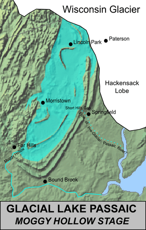
The glacier piled a huge amount of earth and rock into the Short Hills Gap. This created a permanent dam, even after the ice started to melt back. With its path to the sea blocked, Glacial Lake Passaic rose higher. It found a new way out through a gap in the southwestern Watchung Mountains. This gap is known as Moggy Hollow.
The Moggy Hollow Stage was the deepest the ancient lake ever got, about 300 feet deep. It also covered the largest area. As the glacier melted, the lake's waters stretched from Wayne to Liberty Corner. During this time, the ridges of Third Watchung Mountain were like a chain of islands in the lake.
Great Notch Stage
The first big drop in Lake Passaic's level happened when the glacier melted enough to reveal the Great Notch. This is a large gap in the First Watchung Mountain in Clifton. In a short time, the lake's level fell about 80 feet. The draining water carved a path that would become the valley of the Third River.
The Great Notch Stage created a lake similar in depth to the Chatham Stage. However, it covered a much larger area. It's thought that Hook Mountain, part of the Third Watchung Mountain, was still an island then.
Postglacial Stages
The Great Notch Stage ended when the glacier melted further. This revealed a gap in the First Watchung Mountain in Paterson. When this gap first opened, it likely caused a flood. This flood carved the valley of Weasel Brook. But the water eventually moved further north, forming the Passaic River's path as we know it today.
This release of water at Paterson destroyed the last ice dam holding back the lake. But the shape of the land and piles of rock still created some bottlenecks. The remains of the Great Notch Stage split into three large lakes. These lakes lasted for another 3,000 to 4,000 years.
Totowa Stage
The Totowa Stage was the northernmost of these three lakes. It stretched from Oakland to Whippany. A dam of glacial sediment in Totowa held the lake back. This dam slowly wore away. The lake's surface fell to its current level, leaving behind areas like Hatfield Swamp and Great Piece Meadows.
Stanley Stage
Upstream from the Totowa Stage, between the Second and Third Watchung Mountains, was the Stanley Stage. This lake was located between Stanley (near Summit) and Millington. It was held back by piles of glacial rock. Like the Totowa stage, this lake's earthen dam eroded. The lake reached its modern level, forming Glenhurst Meadows.
Millington Stage
The Millington Stage was the furthest upstream of the three lakes. It was probably about 50 feet deep at its deepest. It filled the basin west of Long Hill, the southernmost ridge of Third Watchung Mountain. Unlike the other two lakes, the Millington Stage drained over the hard rock crest of Long Hill.
But even rock couldn't hold back one of the last parts of Glacial Lake Passaic. Around 14,000 years ago, water spilling through a gap in Long Hill carved the Millington Gorge. This lowered the lake's level to form the Great Swamp we see today.
The Modern Lake Basin
Conservation Efforts

The areas that were once Glacial Lake Passaic are now several swamps in northern New Jersey. The most famous is the Great Swamp. It's located south of Morristown and through Chatham Township. It's mostly in southern Morris County and northeastern Somerset County.
The Great Swamp is a very important watershed. Several smaller streams combine their waters there to form the Passaic River. The river then flows out of the swamp through the Millington Gorge.
In the 1950s, there was a plan to build a huge airport that would have destroyed this natural area. Local residents started a major effort to save it. They bought up land for a year, starting in 1959. In 1960, they donated over 7,600 acres (about 12 square miles) to the government. This land became the Great Swamp National Wildlife Refuge. Citizens from nearby towns still watch over it. More land has been added to the refuge over the years.
Flooding Issues
The central Passaic basin often experiences severe flooding. This is especially true where the Passaic and Pompton rivers meet. This area is upstream from natural narrow points in the river. Sometimes, so much water collects that parts of the old Totowa Stage of Glacial Lake Passaic briefly reappear. It takes time for all this water to drain away. There have been proposals, like the Passaic River Flood Tunnel, to create a new path for this trapped water.
 | Shirley Ann Jackson |
 | Garett Morgan |
 | J. Ernest Wilkins Jr. |
 | Elijah McCoy |


