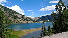
Lake San Cristobal facts for kids
Quick facts for kids Lake San Cristobal |
|
|---|---|
 |
|
| Location | Hinsdale County, Colorado |
| Coordinates | 37°58′15″N 107°17′27″W / 37.97083°N 107.29083°W |
| Lake type | Barrier lake |
| Basin countries | United States |
| Max. length | 3.3 km (2.1 mi) |
| Surface area | 1.34 km2 (0.52 sq mi) |
| Max. depth | 27 m (89 ft) |
| Water volume | 14,000,000 m3 (490,000,000 cu ft) |
| Surface elevation | 2,744 m (9,003 ft) |
Lake San Cristobal is a beautiful lake located in the U.S. state of Colorado. You can find it high up in the San Juan Mountains. It sits at an elevation of about 2,744 meters (9,003 feet) above sea level.
This freshwater lake is quite long, stretching about 3.3 kilometers (2.1 miles). It can be as deep as 27 meters (89 feet) in some spots. The lake covers an area of about 1.34 square kilometers (0.52 square miles). It holds a huge amount of water, around 14 million cubic meters (11,000 acre-feet).
The nearby town of Lake City is actually named after Lake San Cristobal. The name San Cristóbal comes from the Spanish language. It means Saint Christopher. Many old silver mines are located near the lake. Even with these old mines, the lake is very clean and well-cared for. It's also a great spot for fishing, as it's stocked with Rainbow Trout.
Contents
How Lake San Cristobal Formed
Lake San Cristobal was created in a very interesting way about 700 years ago. A huge natural landslide happened, called the Slumgullion Earthflow. This landslide moved a lot of earth and rocks. It ended up forming a natural dam across the Lake Fork of the Gunnison River. This dam then caused the river water to back up, creating the lake we see today.
Understanding Landslide Dams
Natural landslide dams are not always permanent. Sometimes, they can break after a long time. For example, a lake called Lake Yashinkul in the former Soviet Union had a dam that broke after 131 years. Because of this, the United States Geological Survey (USGS) looked into whether the Lake San Cristobal dam might also fail.
The USGS studied the dam carefully. They found that the material making up the dam is not porous, meaning water doesn't easily soak through it. Also, part of the dam's natural overflow channel, called a spillway, is actually cut into solid bedrock. This means it's very strong and stable. The USGS concluded that the dam is safe and stable.
Sediment and the Lake's Future
Over time, tiny bits of rock and soil, called sediment, wash into the lake. This sediment comes from the Lake Fork and Slumgullion Creek. These sediments are slowly filling up the lake. However, this process is very slow. Scientists don't think it will affect the dam's stability. If the lake continues to fill at the same rate, it would take about 2,500 years for it to be completely filled with sediment.
Managing the Lake's Water Level
In the 1950s, the USGS considered building an artificial dam at Lake San Cristobal. This new dam would have been much larger. However, this idea was not pursued. There were concerns that the active part of the Slumgullion Earthflow could one day reach the dam site. Also, more water pressure from a deeper lake could make the lower part of the landslide move again.
Over the years, people have made small changes to control the lake's water level. In 1954, Hinsdale County built a small dam of rocks and wood at the lake's outlet. But this structure started to wear out by the 1970s.
As of 2009, the lake's water level is managed by adding and removing large boulders at the lake's outlet during different seasons. The county has suggested a new plan to change the outlet structure. This would allow them to store and release water in a more controlled way. This new method is expected to have a similar effect on the lake's level as the current practice.
See also
 In Spanish: Lago San Cristóbal para niños
 | John T. Biggers |
 | Thomas Blackshear |
 | Mark Bradford |
 | Beverly Buchanan |


