Lebanon Township, New Jersey facts for kids
Quick facts for kids
Lebanon Township, New Jersey
|
||
|---|---|---|
|
Township
|
||
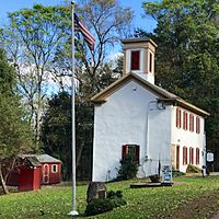
Lebanon Township Museum
|
||
|
||
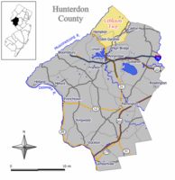
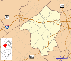
Location of Lebanon Township in Hunterdon County highlighted in yellow (right). Inset map: Location of Hunterdon County in New Jersey highlighted in black (left).
|
||
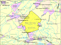
Census Bureau map of Lebanon Township, New Jersey
|
||
| Country | ||
| State | ||
| County | ||
| First mention | October 26, 1731 | |
| Incorporated | February 21, 1798 | |
| Government | ||
| • Type | Township | |
| • Body | Township Committee | |
| Area | ||
| • Total | 31.68 sq mi (82.05 km2) | |
| • Land | 31.43 sq mi (81.40 km2) | |
| • Water | 0.25 sq mi (0.66 km2) 0.80% | |
| Area rank | 81st of 565 in state 7th of 26 in county |
|
| Elevation | 925 ft (282 m) | |
| Population
(2020)
|
||
| • Total | 6,195 | |
| • Estimate
(2023)
|
6,212 | |
| • Rank | 339th of 565 in state 5th of 26 in county |
|
| • Density | 197.1/sq mi (76.1/km2) | |
| • Density rank | 504th of 565 in state 18th of 26 in county |
|
| Time zone | UTC−05:00 (Eastern (EST)) | |
| • Summer (DST) | UTC−04:00 (Eastern (EDT)) | |
| ZIP Code |
07830, 07865, 07882, 08809, 08826, 08827
|
|
| Area code(s) | 908 | |
| FIPS code | 3401939660 | |
| GNIS feature ID | 0882191 | |
| Website | ||
Lebanon Township is a community located in the northern part of Hunterdon County, in the state of New Jersey. It's the northernmost township in the county.
In 2020, about 6,195 people lived here. The township is part of the Raritan Valley region. It shares borders with Morris and Warren counties. When Lebanon Township was first created in 1731, it was much larger.
Contents
History of Lebanon Township
Lebanon Township was first mentioned on October 26, 1731. It was formed partly from an older area called Amwell Township. We don't know the exact details of how it was created.
On February 21, 1798, Lebanon Township officially became one of New Jersey's first 104 townships. Over time, parts of the township were used to create other towns. These include Tewksbury Township (1755), Clinton Township (1841), and several boroughs like High Bridge (1898) and Califon (1898).
Two historic churches in the area are Spruce Run Evangelical Lutheran Zion Church, founded in 1774, and Mt. Bethel Evangelical Lutheran Church. The Mt. Bethel church has a cemetery with graves dating back to 1801.
In April 2024, a magnitude 4.8 earthquake happened in New Jersey. Its center was in Lebanon Township.
Geography and Natural Areas
Lebanon Township covers about 31.68 square miles (82.05 square kilometers). Most of this area is land.
Several small communities and places are located within the township. These include Anthony, Bunnvale, Changewater, and New Hampton.
The township borders several other towns and townships. These are in Hunterdon County, Morris County, and Warren County.
Population and People
| Historical population | |||
|---|---|---|---|
| Census | Pop. | %± | |
| 1810 | 2,419 | — | |
| 1820 | 2,817 | 16.5% | |
| 1830 | 3,436 | 22.0% | |
| 1840 | 3,849 | 12.0% | |
| 1850 | 2,128 | * | −44.7% |
| 1860 | 2,495 | 17.2% | |
| 1870 | 3,561 | 42.7% | |
| 1880 | 2,699 | −24.2% | |
| 1890 | 2,337 | −13.4% | |
| 1900 | 2,253 | * | −3.6% |
| 1910 | 2,179 | −3.3% | |
| 1920 | 1,083 | * | −50.3% |
| 1930 | 1,269 | 17.2% | |
| 1940 | 1,437 | 13.2% | |
| 1950 | 1,971 | 37.2% | |
| 1960 | 2,841 | 44.1% | |
| 1970 | 4,235 | 49.1% | |
| 1980 | 5,459 | 28.9% | |
| 1990 | 5,679 | 4.0% | |
| 2000 | 5,816 | 2.4% | |
| 2010 | 6,588 | 13.3% | |
| 2020 | 6,195 | −6.0% | |
| 2023 (est.) | 6,212 | −5.7% | |
| Population sources: 1810–1920 1840 1850–1870 1850 1870 1880–1890 1890–1910 1910–1930 1940–2000 2000 2010 2020 * = Lost territory in previous decade. |
|||
In 2010, there were 6,588 people living in Lebanon Township. Most residents were White (95.01%). About 3.11% of the population was Hispanic or Latino.
The average household had about 2.71 people. Families usually had 3.11 people. About 22.6% of the population was under 18 years old. The median age was 45.4 years.
Arts and Culture
Lebanon Township is home to the Sleepy Man Banjo Boys. This is a bluegrass music group made up of three brothers: Jonny (banjo), Robbie (fiddle), and Tommy (guitar).
Parks and Outdoor Activities
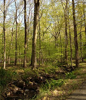
Lebanon Township has part of the Columbia Trail. This trail was once a railroad line called the Central Railroad of New Jersey High Bridge Branch. It's now a great place for walking and biking.
A very beautiful part of the trail is called the Ken Lockwood Gorge.
Education and Schools
The Lebanon Township Schools serve students from pre-kindergarten through eighth grade. There are two schools in the district:
- Valley View School: For students in Pre-K through 4th grade.
- Woodglen School: For students in 5th through 8th grade.
Both schools are in Lebanon Township, but they use a Califon mailing address.
Students in ninth through twelfth grades attend Voorhees High School. This high school also serves students from several nearby towns. Voorhees High School is part of the North Hunterdon-Voorhees Regional High School District.
Students in eighth grade from all over Hunterdon County can apply to the Hunterdon County Vocational School District. This district offers special career and technical programs.
Lebanon Township is also home to the Hunterdon Learning Center. This is an alternative education school that started in 1975.
Places to Visit
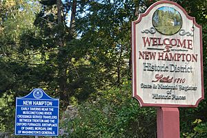
The New Hampton Historic District is a special area listed on the National Register of Historic Places. It includes the New Hampton Pony Pratt Truss Bridge.
The Lebanon Township Museum is also part of this historic district. It was built around 1825. The museum has a memorial for General Daniel Morgan. He was born here and was an important soldier in the American Revolutionary War.
Transportation and Roads
As of 2010, Lebanon Township had about 89.89 miles of roads. Most of these roads are maintained by the township itself.
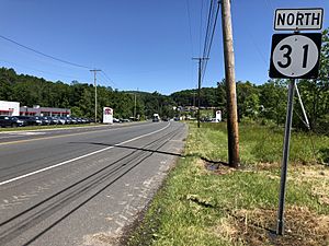
Route 31 goes through the township. This road helps people get to Interstate 78.
For public transportation, there used to be a local bus service (NJ Transit's 884 route), but it stopped in 2010. Train service is available nearby at the High Bridge station. This station is part of the Raritan Valley Line.
The Hunterdon County LINK also provides bus service on Route 15. This route goes through the western part of the township along Route 31.
Notable People from Lebanon Township
Many interesting people have lived in or are connected to Lebanon Township:
- Adrienne Adams (1906–2002), a famous illustrator of children's books.
- Lonzo Anderson (1905–1993), an author who wrote books for children.
- Julie Culley (born 1981), an Olympic runner who competed in the 2012 US Olympic Team for the women's 5000m race.
- Mary Decker (born 1958), a well-known former track athlete.
- Merv Griffin (1925–2007), a television producer who owned a farm in the township.
- Daniel Morgan (1735–1802), a soldier and politician from the American Revolutionary War. He was known for his battlefield skills.
- Joe Piscopo (born 1951), a comedian and actor, famous for his work on Saturday Night Live.
- Bernie Worrell (1944–2016), a keyboardist and a founding member of the band Parliament-Funkadelic.
See also
 In Spanish: Municipio de Lebanon (Nueva Jersey) para niños


