Lexington, Oregon facts for kids
Quick facts for kids
Lexington, Oregon
|
|
|---|---|

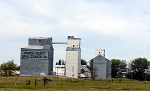
Grain elevators in Lexington, May 2009
|
|

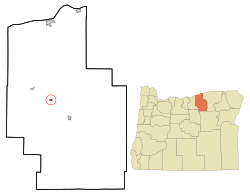
Location in Oregon
|
|
| Country | United States |
| State | Oregon |
| County | Morrow |
| Incorporated | 1903 |
| Area | |
| • Total | 0.44 sq mi (1.13 km2) |
| • Land | 0.44 sq mi (1.13 km2) |
| • Water | 0.00 sq mi (0.00 km2) |
| Elevation | 1,450 ft (440 m) |
| Population
(2020)
|
|
| • Total | 238 |
| • Density | 544.62/sq mi (210.49/km2) |
| Time zone | UTC-8 (Pacific) |
| • Summer (DST) | UTC-7 (Pacific) |
| ZIP code |
97839
|
| Area code(s) | 541 |
| FIPS code | 41-42200 |
| GNIS feature ID | 2412892 |
Lexington is a small city located in Morrow County, Oregon, in the United States. In 2010, about 238 people lived there. It is part of a larger area that includes the cities of Pendleton and Hermiston.
Contents
History of Lexington, Oregon
Lexington was named by an early settler, William Penland. He named it after his hometown, Lexington, Kentucky. The first post office in Lexington opened in 1885.
In 1886, Lexington almost became the main city (county seat) of Morrow County. However, it lost to Heppner by just 33 votes. The city officially became a city in 1903. By 1910, its population was 185 people.
Long ago, sheep ranching was a very important activity in this area. Today, people still raise sheep, but they also grow wheat and raise cattle.
Geography and Location
Lexington is located between the Columbia River to the north and the Blue Mountains to the southeast. The city is along Oregon Route 74. It is about 9 miles (14 km) northwest of Heppner.
Lexington is also about 38 miles (61 km) southwest of Hermiston. It is much further, about 174 miles (280 km), east of Portland.
Willow Creek flows right through Lexington. This creek also passes through Heppner (upstream) and Ione and Arlington (downstream). The city covers an area of about 0.44 square miles (1.13 square kilometers), and all of it is land.
Route 74 is part of the Blue Mountain Scenic Byway. This byway is a 130-mile (209 km) road that connects Interstate 84 near the Columbia River to the North Fork John Day River in the Blue Mountains. Part of this scenic route follows the Willow Creek area through Lexington.
Economy and Education
In 2002, the biggest employers in Lexington included the Morrow County Grain Growers, which are farms. Other major employers were the Columbia Basin Electric Co-op in Heppner and a metal company in Heppner. There was also a small company in Lexington that fixed farm equipment.
The main office for the Morrow County School District is in Lexington. However, the closest public schools for students are located in Heppner.
Population Changes Over Time
| Historical population | |||
|---|---|---|---|
| Census | Pop. | %± | |
| 1870 | 23 | — | |
| 1890 | 100 | — | |
| 1900 | 175 | 75.0% | |
| 1910 | 185 | 5.7% | |
| 1920 | 264 | 42.7% | |
| 1930 | 180 | −31.8% | |
| 1940 | 223 | 23.9% | |
| 1950 | 237 | 6.3% | |
| 1960 | 240 | 1.3% | |
| 1970 | 230 | −4.2% | |
| 1980 | 307 | 33.5% | |
| 1990 | 286 | −6.8% | |
| 2000 | 263 | −8.0% | |
| 2010 | 238 | −9.5% | |
| 2020 | 238 | 0.0% | |
| source: | |||
Lexington's Population in 2010
According to the census from 2010, 238 people lived in Lexington. There were 94 households, which are groups of people living together. Out of these, 70 were families. The city had about 540.9 people per square mile (208.8 per square kilometer).
Most of the people in Lexington were White (92.4%). A small number were Asian (0.4%), or from two or more races (5.5%). About 1.3% of the population was Hispanic or Latino.
In the households, 28.7% had children under 18 living with them. More than half (60.6%) were married couples. About 9.6% had a female head of the house without a husband. And 4.3% had a male head of the house without a wife.
The average age of people in Lexington was 43 years old. About 24.4% of residents were under 18. And 17.6% were 65 years old or older. There were slightly more males (55%) than females (45%) in the city.
Transportation in Lexington
The Lexington Airport is open to the public. It is located about one mile north of the city. On average, about 85 aircraft use the airport each week. Most of these flights are local. During certain seasons, many flights are related to farming activities.
See also
 In Spanish: Lexington (Oregón) para niños

