Liberty, Maine facts for kids
Quick facts for kids
Liberty, Maine
|
|
|---|---|

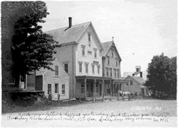
Masonic Building on Main Street, c. 1904
|
|

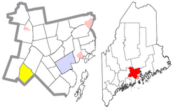
Location of Liberty (in yellow) in Waldo County and the state of Maine
|
|
| Country | United States |
| State | Maine |
| County | Waldo |
| Area | |
| • Total | 28.40 sq mi (73.56 km2) |
| • Land | 26.00 sq mi (67.34 km2) |
| • Water | 2.40 sq mi (6.22 km2) |
| Elevation | 650 ft (198 m) |
| Population
(2020)
|
|
| • Total | 934 |
| • Density | 36/sq mi (13.9/km2) |
| Time zone | UTC-5 (Eastern (EST)) |
| • Summer (DST) | UTC-4 (EDT) |
| ZIP code |
04949
|
| Area code(s) | 207 |
| FIPS code | 23-39055 |
| GNIS feature ID | 0582555 |
| Website | Town of Liberty |
Liberty is a small town located in Waldo County, Maine, United States. In 2020, about 934 people lived there.
Contents
History of Liberty
The area of midcoast Maine was once home to Native American groups like the Abenaki (also known as Wabanaki). However, starting in the 1600s, many European settlers arrived and caused these groups to move away from their traditional lands.
The first European people, who were English, began settling in the Liberty area in the late 1700s. This early settlement was called Davistown Plantation. Later, in the early 1800s, it became part of the nearby town of Montville.
Mills in Liberty played an important role. They made materials used in the shipbuilding industry. This industry was very busy in coastal towns nearby, like Waldoboro, during the early 1800s.
In 1827, Liberty became its own separate town, no longer part of Montville.
From the mid to late 1800s, the town's population and the amount of goods it produced started to decrease. This happened as the shipbuilding industry also became less active.
Geography of Liberty
Liberty covers a total area of about 28.40 square miles (73.56 square kilometers). Most of this area, about 26.00 square miles (67.34 square kilometers), is land. The rest, about 2.40 square miles (6.22 square kilometers), is water.
Water Bodies in Liberty
The biggest body of water in Liberty is St. George Lake. Other important water bodies include:
- Stevens Pond (339 acres)
- Trues Pond (173 acres)
- Little Pond (69 acres)
- Cargill Pond (57 acres)
- Colby Pond (26 acres)
Roads and Borders
Liberty is served by several main roads, including Maine State Routes 3, 220, and 173.
The town shares its borders with several other towns:
- To the north: Montville
- To the east: Searsmont
- To the southeast: Appleton
- To the southwest: Washington
- To the west: Palermo
Liberty is also home to Lake St. George State Park, a great place for outdoor activities.
Population in Liberty
| Historical population | |||
|---|---|---|---|
| Census | Pop. | %± | |
| 1830 | 676 | — | |
| 1840 | 895 | 32.4% | |
| 1850 | 1,116 | 24.7% | |
| 1860 | 1,095 | −1.9% | |
| 1870 | 907 | −17.2% | |
| 1880 | 970 | 6.9% | |
| 1890 | 835 | −13.9% | |
| 1900 | 737 | −11.7% | |
| 1910 | 650 | −11.8% | |
| 1920 | 571 | −12.2% | |
| 1930 | 516 | −9.6% | |
| 1940 | 499 | −3.3% | |
| 1950 | 497 | −0.4% | |
| 1960 | 458 | −7.8% | |
| 1970 | 515 | 12.4% | |
| 1980 | 694 | 34.8% | |
| 1990 | 790 | 13.8% | |
| 2000 | 927 | 17.3% | |
| 2010 | 913 | −1.5% | |
| 2020 | 934 | 2.3% | |
| U.S. Decennial Census | |||
2010 Census Details
According to the census from 2010, there were 913 people living in Liberty. These people made up 395 households, and 259 of those were families.
The population density was about 35.1 people for every square mile. There were 718 housing units, which are places where people live.
Most of the people in Liberty were White (97.3%). A small number were African American (0.2%), Native American (0.7%), Pacific Islander (0.1%), or from other backgrounds. About 1.6% of people identified as being from two or more races. Less than 1% of the population (0.4%) was Hispanic or Latino.
Households and Age Groups
Out of the 395 households:
- 26.1% had children under 18 living with them.
- 50.9% were married couples living together.
- 9.1% had a female head of household with no husband present.
- 5.6% had a male head of household with no wife present.
- 34.4% were made up of individuals not living as a family.
About 29.4% of all households were single individuals, and 9.4% had someone aged 65 or older living alone. The average household had 2.31 people, and the average family had 2.83 people.
The average age of people in Liberty was 47.2 years old.
- 21.7% of residents were under 18.
- 5.4% were between 18 and 24.
- 20.1% were between 25 and 44.
- 38.2% were between 45 and 64.
- 14.7% were 65 years old or older.
The population was almost evenly split between genders, with 51.5% male and 48.5% female.
Notable Person
- Susan Longley is a state legislator who has served in the government.
See also
 In Spanish: Liberty (Maine) para niños
 | John T. Biggers |
 | Thomas Blackshear |
 | Mark Bradford |
 | Beverly Buchanan |

