
Lincoln Cliff facts for kids
The Lincoln Cliff (also known as the Lincoln Edge) is a long, low hill that stretches through the middle of Lincolnshire, England. It's a really noticeable feature in a part of the country that's mostly flat. Think of it like a natural wall running north to south!
Contents
What is the Lincoln Cliff?
This natural "wall" is made from strong rocks that formed during the Jurassic period, a very long time ago. The main rock is called the Lincolnshire Limestone. Even though it's long and straight, it's not super tall – it only rises about 50 metres (around 164 feet) above the land around it.
The Lincoln Cliff stretches for over 50 miles (about 80 kilometres)! It goes all the way from the border with Leicestershire near Grantham up to the Humber Estuary. It's only broken in two places where rivers flow through: at Ancaster (where the Slea flows) and at Lincoln (where the Witham flows).
To the west of the Cliff, north of Lincoln, you'll find the River Trent. South of Lincoln, the Witham valley is to the west.
Roads and Names
Two old and important roads follow the top of the Lincoln Cliff. One is an ancient path called the Jurassic Way. Today, parts of it are modern roads like the A607 south of Lincoln and the B1398 to the north. The second road is the Roman Ermine Street, which runs a few miles to the east.
Sometimes, people use the name "Lincoln Cliff" to mean the whole ridge of limestone rock, especially north of Lincoln. You might see village names like Welton Cliff or Saxby Cliff. South of Lincoln, "Cliff" usually just means the steep western side, while the flat top is called the Lincoln Heath. To avoid confusion, some people prefer to call the whole long ridge the "Lincoln Edge" or "Lincolnshire Edge."
How the Cliff Formed (Geology)
The Lincoln Cliff is one of several west-facing slopes in Lincolnshire. It's made from layers of sedimentary rocks that gently slope down towards the east. The older rocks to the west are from the Early Jurassic period, and the younger ones to the east are from the Middle Jurassic period.
The main rocks you'd find are:
- Lincolnshire Limestone Formation
- Grantham Formation
- Northampton Sand Formation
- Whitby Mudstone Formation
- Marlstone Rock Formation
- Charmouth Mudstone Formation
The Charmouth Mudstones form the lower ground to the west. The Lincolnshire Limestone forms the flat top of the cliff to the east.
The two gaps in the ridge at Lincoln and Ancaster are interesting! Scientists believe these gaps show where an ancient river, called the "proto-Trent," used to flow. This old river flowed from the Nottingham area towards the North Sea. It first went through the gap at Ancaster, then later through the Lincoln Gap. Eventually, the river changed its path to its current northerly course, joining the Yorkshire Ouse to form the Humber.
Cliff Villages

Many villages are found along the Lincoln Cliff. These are often called "spring-line villages" because they are located where springs (natural water sources) come out of the ground. Here are some of them, listed from north to south:
- Winteringham, on the bank of the Humber
- Winterton
- Roxby
- Burton upon Stather
- Scunthorpe
- Kirton in Lindsey
- Grayingham
- Blyborough
- Willoughton
- Hemswell
- Harpswell
- Glentworth
- Fillingham
- Ingham
- Cammeringham
- Brattleby
- Aisthorpe
- Scampton
- North Carlton
- South Carlton
- Burton by Lincoln
- Lincoln – where the River Witham flows through
- Canwick
- Bracebridge Heath
- Waddington
- Harmston
- Coleby
- Boothby Graffoe
- Navenby
- Wellingore
- Welbourn
- Leadenham
- Fulbeck
- Caythorpe
- Normanton
- Carlton Scroop
- Ancaster – where the River Slea flows through
- Honington
- Barkston
- Syston
- Belton
- Londonthorpe
- Manthorpe
- Grantham
Images for kids
-
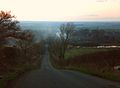
View from Lincoln Cliff above Welbourn (2009)

