List of axial multiple-stone circles facts for kids
An axial stone circle is a special kind of stone circle found mostly in southwest Ireland. These ancient stone rings were built by people long ago. This article is about "multiple-stone" circles, which means they have seven or more stones.

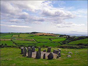
These circles have a special design. They are almost perfectly balanced, like a mirror image, along a line that runs from northeast to southwest. One stone, called the axial stone, is different from the others. It lies flat on the ground on the southwest side of the circle, instead of standing upright. This flat stone helps mark the main line of the circle. It's usually quite thin and sits along the edge of the stone ring.
Contents
What are Axial Stone Circles?
These amazing stone circles were built during the Bronze Age, a time from about 2400 BC to 500 BC. When they were first made, they always had an odd number of stones. Two stones, called portal stones, were placed on either side of the circle's main line at the northeast entrance.
You can find most of these circles in County Cork and County Kerry in Ireland. There is also one in County Clare.
How They Got Their Name
A long time ago, in the early 1900s, people called them "recumbent stone circles" because they seemed similar to circles found in Scotland. "Recumbent" means lying down, referring to the flat axial stone.
But soon, experts realized there were big differences. So, they started calling them "Cork–Kerry stone circles" because that's where most of them are. Later, the name "axial stone circle" became popular. This name highlights the special axial stone that lies flat.
Official Definition
Ireland's National Monuments Service, which looks after old sites, describes these circles like this:
A special type of stone circle found only in counties Cork and Kerry. It has a ring of standing stones, always an odd number (between 7 and 19). They are arranged in a balanced way so that one stone, the axial stone, is directly opposite two stones, usually the tallest, which mark the entrance to the circle. The stones typically get shorter as you move towards the axial stone, which is always in the southwest part of the circle. These circles are usually less than 10 meters (about 33 feet) across. These circles were part of burial and religious customs during the Bronze Age (around 2400-500 BC).
—National Monuments Service
There are 41 of these sites in County Cork, 15 in County Kerry, and one in County Clare.
List of Axial Multiple-Stone Circles
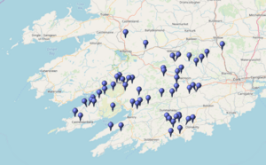
The map above shows where the 56 sites in Cork and Kerry are located. The one in County Clare is not on this map. You can see all these places on an online map viewer by clicking the OpenStreetMap link.
| Townland | SMR No. | Ref. | Diameter (metre) |
Num. stones | Status Notes |
Lat/long | Irish Grid |
|---|---|---|---|---|---|---|---|
| Ahagilla | CO121-100---- | 7 | 3/? | ruin | 51°38′28″N 8°57′47″W / 51.641°N 8.963°W | W334436 | |
| An Dromaid (Dromod) | KE089-053---- | (39 8) |
4 | 5/7* | ruin | 51°51′25″N 10°06′54″W / 51.857°N 10.115°W | V544693 |
| Ardgroom SW | CO102-006001- | 302 (21 9) |
7.3 | 10/11 | good | 51°44′10″N 9°52′12″W / 51.736°N 9.87°W | V709553 |
| Ardgroom NE | CO102-010---- | 302 (20 8) |
3/5+ | gone | 51°44′46″N 9°51′22″W / 51.746°N 9.856°W | V719565 | |
| Ballyvackey | CO135-005001- | (35 3) |
8.5 | 7/9* | ruin | 51°37′59″N 8°56′53″W / 51.633°N 8.948°W | W344427 |
| Bohonagh | CO143-032001- | 304 (36 1) |
9.9 | 13 | good excav. |
51°34′52″N 9°00′00″W / 51.581°N 9°W | W308369 |
| Breeny More | CO106-005001- | 305 (24 6 |
14 | 5+ | gone | 51°44′31″N 9°22′30″W / 51.742°N 9.375°W | W510553 |
| Cappanaboul | CO105-029001- | (22 5) |
10.5 | 10/13* | ruin | 51°43′26″N 9°23′53″W / 51.724°N 9.398°W | W340533 |
| Carrigagrenane (SW) | CO134-008---- | 308 (33 3) |
8.5 | 13/19 | ruin | 51°38′13″N 9°04′41″W / 51.637°N 9.078°W | W254432 |
| Carrigagulla (SW) | CO049-008---- | 310 (4 4) |
9 | 15/17* | ruin | 52°00′00″N 8°54′58″W / 52°N 8.916°W | W371835 |
| Carrigaphooca | CO070-035---- | (11 4) |
5.5 | 5+ | ruin | 51°54′32″N 9°01′41″W / 51.909°N 9.028°W | W293735 |
| Cashelkeelty (W) | KE108-013001- | 344 (47 -) |
17 | 3/11 or 13 | gone excav. |
51°45′25″N 9°48′54″W / 51.757°N 9.815°W | V747576 |
| Coolaclevane | CO082-066---- | (13 3) |
7.5 | 9 | ruin | 51°49′26″N 9°02′06″W / 51.824°N 9.035°W | W287640 |
| Coollick | KE058-134---- | 10/? | good | 52°07′59″N 9°30′32″W / 52.133°N 9.509°W | V967989 | ||
| Coolmountain | CO093-013---- | (17 8) |
9.2 | 2/11* | gone | 51°47′38″N 9°10′19″W / 51.794°N 9.172°W | W192608 |
| Coulagh | CO114-002---- | (25 2) |
8.5 | 5+ | gone | 51°40′44″N 9°58′44″W / 51.679°N 9.979°W | V632492 |
| Currabeha (S) | CO083-109002- | (14 2) |
7 | 5/9 or 11 | ruin | 51°49′41″N 8°51′22″W / 51.828°N 8.856°W | W411643 |
| Currabeha (N) | CO083-110---- | (15 4) |
8.5 | 13* | gone | 51°49′34″N 8°51′14″W / 51.826°N 8.854°W | W412640 |
| Curraghodea | CL031-052---- | 52°51′58″N 9°17′42″W / 52.866°N 9.295°W | R128802 | ||||
| Derreenataggart West | CO115-011002- | 316 (26 2) |
7.7 | 15* | ruin | 51°39′14″N 9°55′44″W / 51.654°N 9.929°W | V665463 |
| Derrynafinchin | CO092-001001- | (16 5) |
8 | 11 or 13 | ruin | 51°48′14″N 9°22′55″W / 51.804°N 9.382°W | W480622 |
| Doughill | KE093-042---- | (42 13) |
9 | 0/17* | gone | 51°52′12″N 9°30′25″W / 51.87°N 9.507°W | V963697 |
| Dromagorteen | KE102-032002- | 10 | 13 | ruin | 51°49′52″N 9°30′43″W / 51.831°N 9.512°W | V959653 | |
| Drombeg | CO143-051002- | (37 1) |
9.3 | 14/17 | good excav. |
51°33′50″N 9°05′13″W / 51.564°N 9.087°W | W247352 |
| Drombohilly Upper | KE109-003001- | 346 (48 2) |
8.5 | 9/11* | ruin | 51°47′13″N 9°45′14″W / 51.787°N 9.754°W | V790608 |
| Dromkeal | CO105-003---- | 9 | 13 | ruin | 51°44′02″N 9°26′38″W / 51.734°N 9.444°W | W300545 | |
| Dromroe | KE101-010001- | 347 (45 7) |
9.5 | 13/13 | ruin | 51°49′59″N 9°37′26″W / 51.833°N 9.624°W | V881657 |
| Dunbeacon | CO130-030---- | 318 (32 1) |
8 | 11 | ruin | 51°35′42″N 9°32′56″W / 51.595°N 9.549°W | V927392 |
| Garryglass | CO120-062---- | (27 -) |
1/11 | gone | 51°39′14″N 9°07′26″W / 51.654°N 9.124°W | W223452 | |
| Glantane East (SW) | CO048-090---- | 319 (3 1) |
5 | 11 | ruin | 51°59′53″N 9°02′53″W / 51.998°N 9.048°W | W281834 |
| Glantane East (NE) | CO048-093---- | (2 9) |
5 | 6/11 or 13* | gone | 52°00′14″N 9°02′42″W / 52.004°N 9.045°W | W283841 |
| Gort An Acra | CO069-015---- | (9 1) |
8 | 13 | ruin | 51°55′37″N 9°09′25″W / 51.927°N 9.157°W | W205756 |
| Gort An Imill | CO069-013---- | 320 (10 4) |
7.8 | 9 | good | 51°54′50″N 9°09′04″W / 51.914°N 9.151°W | W209741 |
| Gorteanish | CO130-016---- | 8 | 11/11 | gone | 51°35′53″N 9°38′42″W / 51.598°N 9.645°W | V861397 | |
| Gortroe | CO094-046---- | 322 (18 9) |
8.5 | 11* | unc. | 51°47′35″N 9°04′34″W / 51.793°N 9.076°W | W258605 |
| Gowlane North | CO050-008---- | (5 3) |
6.5 | 8/9* | ruin | 52°01′16″N 8°45′07″W / 52.021°N 8.752°W | W484856 |
| Gurteen | KE094-021001- | 348 (43 7) |
10.5 | 11/11 | good | 51°52′19″N 9°26′42″W / 51.872°N 9.445°W | W500698 |
| Kealagowlane | CO104-027001- | 8 | 11/11 | ruin | 51°42′43″N 9°37′37″W / 51.712°N 9.627°W | V876523 | |
| Kenmare | KE093-032001- | 349 (41 7) |
17x15 | 15/15 | good | 51°52′41″N 9°35′17″W / 51.878°N 9.588°W | V907707 |
| Kilboultragh | CO059-151---- | (7 8) |
9 | 0/11 | gone | 51°55′48″N 8°59′20″W / 51.93°N 8.989°W | W320757 |
| Killowen | KE093-018---- | (40 12) |
10 | 0/11 | gone | 51°53′13″N 9°34′01″W / 51.887°N 9.567°W | V922716 |
| Kilmartin Lower | CO050-061001- | (6 9) |
3.4 | 6/7 | ruin | 51°59′28″N 8°48′00″W / 51.991°N 8.8°W | W451824 |
| Knocknaneirk | CO095-016---- | (19 1) |
9.5 | 7/9* | good | 51°48′47″N 8°54′47″W / 51.813°N 8.913°W | W371626 |
| Knocks (NW) | CO121-063---- | (28 3) |
9 | 11* | ruin | 51°39′32″N 9°00′47″W / 51.659°N 9.013°W | W299456 |
| Knocks (SE) | CO121-067---- | (29 8) |
8.5 | 5+ | gone | 51°38′49″N 9°00′32″W / 51.647°N 9.009°W | W302443 |
| Lackaroe | KE093-050001- | 8 | 8/13 | ruin | 51°51′43″N 9°30′47″W / 51.862°N 9.513°W | V958688 | |
| Lissard | CO042-074001- | (1 -) |
8 | 0/5+ | gone | 52°03′50″N 8°36′32″W / 52.064°N 8.609°W | W583903 |
| Lohart | KE101-007001- | 351 (44 -) |
11 | 5+ | restored | 51°50′13″N 9°42′25″W / 51.837°N 9.707°W | V824663 |
| Maughanaclea (NE) | CO106-016001- | 329 (23 5) |
11.5 | 12/13* | ruin | 51°45′14″N 9°17′49″W / 51.754°N 9.297°W | W105565 |
| Maulatanvally | CO121-057---- | 331 (30 4) |
9.5 | 7/11* | ruin | 51°38′46″N 9°03′54″W / 51.646°N 9.065°W | W263442 |
| Oughtihery (SE) | CO060-042---- | 334 (8 8) |
2.9 | 5/7* | ruin | 51°58′12″N 8°51′04″W / 51.97°N 8.851°W | W415801 |
| Readrinagh | KE068-085---- | 10.7 | 0/29 | gone | 52°04′16″N 9°19′19″W / 52.071°N 9.322°W | W940918 | |
| Reanascreena South | CO134-032---- | 335 (34 11) |
9.8x9.3 | 13/13 | good excav. |
51°37′05″N 9°03′47″W / 51.618°N 9.063°W | W264411 |
| Shronebirrane | KE108-022---- | 353 (46 2) |
7.5 | 9/13* | ruin | 51°44′13″N 9°48′14″W / 51.737°N 9.804°W | V754554 |
| Teergay | CO070-108---- | 338 (12 3) |
7.5 | 8/9* | ruin | 51°52′23″N 9°01′48″W / 51.873°N 9.03°W | W291694 |
| Templebryan North | CO122-076---- | 339 (31 4) |
9.5 | 5/9* | ruin | 51°38′35″N 8°52′59″W / 51.643°N 8.883°W | W389437 |
| Uragh (SW) | KE101-025001- | 9.5x7.5 | 10/11 | ruin | 51°48′29″N 9°42′14″W / 51.808°N 9.704°W | V825630 |
See also
 | Jackie Robinson |
 | Jack Johnson |
 | Althea Gibson |
 | Arthur Ashe |
 | Muhammad Ali |


