
List of bridges on the National Register of Historic Places in Kansas facts for kids
Kansas is home to many old and important bridges and tunnels. These structures are more than just ways to cross rivers or go through hills; they are also a big part of the state's history. Many of these special bridges and tunnels are listed on the National Register of Historic Places. This means they are recognized for their historical importance and unique design.
These historic structures show us how people built things in the past. They tell stories about how towns grew and how people traveled across Kansas long ago. From strong stone arches to clever metal trusses, each bridge has its own story.
Contents
What Makes a Bridge Historic?
A bridge becomes historic when it's old and has special meaning. This could be because it's a great example of a certain building style, or because it played an important role in local history. When a bridge is listed on the National Register of Historic Places, it means it's protected and its history is celebrated.
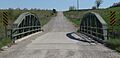
Different Types of Historic Bridges
Kansas has many different kinds of old bridges. Each type was built using different engineering ideas to be strong and last a long time.
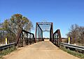
Truss Bridges
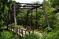
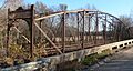
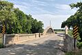
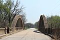
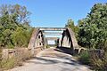
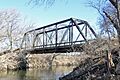
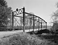
Truss bridges are built with a framework of triangles. This shape makes them very strong and able to carry heavy loads. Many old truss bridges in Kansas were built in the late 1800s and early 1900s.
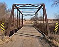
- The Atchison, Topeka, and Santa Fe Pratt Truss Bridge was built in 1909 near Melvern. A Pratt truss uses diagonal pieces that slant towards the center of the bridge.
- The Elk Falls Pratt Truss Bridge from 1892-1893 is another great example. It's located in Elk Falls.
- The Clear Creek Camel Truss Bridge in Baileyville (built 1930) has a unique "camelback" shape, which means the top part of the truss curves like a camel's hump.
- The Republican River Pegram Truss near Concordia (built 1893) is a special type of truss designed by an engineer named George H. Pegram.
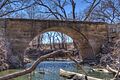
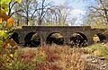
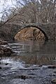
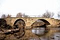
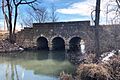
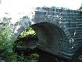
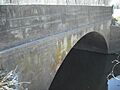
Stone Arch Bridges
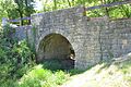
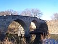
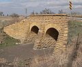
Stone arch bridges are some of the oldest and most beautiful bridges. They are built with carefully cut stones that fit together to form a strong arch. These bridges often look like something out of a fairy tale!
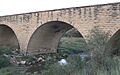
- The Clements Stone Arch Bridge in Clements was built way back in 1886. It's one of the most famous stone arch bridges in Kansas.
- The Esch's Spur Bridge near Dexter, built around 1915, is another lovely example of a stone arch bridge.
- The Morton County WPA Bridge (1936) near Richfield was built during the Great Depression by the Works Progress Administration (WPA), a government program that created jobs.
Concrete Bridges
As technology advanced, builders started using concrete more often. Concrete bridges can be very strong and can take on many different shapes.
- The Amelia Park Bridge (1914) in Antelope is an early concrete bridge.
- The Bucher Bridge (1905) near Rock is a reinforced concrete arch bridge, meaning it has steel bars inside the concrete for extra strength.
- The John Mack Bridge in Wichita, built in 1930-1931, is a "rainbow" reinforced concrete bridge. It has a beautiful arch shape that looks like a rainbow.
Other Unique Bridges
Some bridges have very specific designs that make them stand out.
- The Hobbs Creek Truss Leg Bedstead Bridge (1904) near Gypsum is a unique type of bridge that looks a bit like an old bed frame.
- The Lyon Creek Rainbow Arch (1925) near Wreford is another "rainbow" bridge, known for its distinctive arch shape.
- The County Line Bowstring (1876) near Hollis and Wayne is a bowstring truss, which has a curved top chord and a straight bottom chord, resembling a bow and arrow.
Bridges That Are No Longer There
Sometimes, even historic bridges can be removed for different reasons, like safety or new construction. However, their history is still remembered.
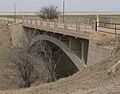
- The Belvidere Medicine River Bridge (1913) in Belvidere was a reinforced concrete arch bridge that was removed in 2000.
- The Schleichers Branch Stone Arch Bridge (around 1898-1900) near Humboldt was also removed in 2004.
These bridges, even if they are gone, remind us of the engineering and hard work of the past.
Images for kids
-
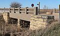
Amelia Park Bridge
-

Atchison, Topeka, and Santa Fe Pratt Truss Bridge
-

Battle Creek King Post Truss Bridge
-
Beaver Creek Native Stone Bridge
-
Blacksmith Creek Bridge
-
Bridge No. 218-Off System Bridge
-
Bridge No. 222-Off System Bridge
-

Bridge No. 640-Federal Aid Highway System Bridge
-

Brush Creek Bridge (Baxter Springs, Kansas)
-
Bucher Bridge
-
Bullfoot Creek Bridge
-
Cedar Creek Bridge (Elgin, Kansas)
-
Chapman Creek Pratt Truss Bridge
-
Chicken Creek Bridge
-
Clear Creek Camel Truss Bridge
-
Clements Stone Arch Bridge
-

Conroe Bridge
-

County Line Bowstring
-

Creamery Bridge
-

Delaware River Parker Truss Bridge
-

Delaware River Warren Truss Bridge
-
East Fork Wolf Creek Pratt Truss Bridge
-

East Stone Arch Bridge - Lake Wabaunsee
-
East Riley Creek Bridge
-

Eight Mile Creek Warren Truss Bridge
-

Elk Falls Pratt Truss Bridge
-

Esch's Spur Bridge
-
Fort Fletcher Stone Arch Bridge
-

Four Mile Creek Lattice
-
Hackberry Creek Bridge
-
Harris Bridge (Americus, Kansas)
-
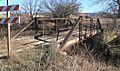
Hobbs Creek Truss Leg Bedstead Bridge
-

Jack Creek Kingpost
-

Jefferson Old Town Bowstring Truss
-
Landers Creek Bridge
-
Little Walnut River Pratt Truss Bridge
-
Long Shoals Bridge
-
Lyon Creek Rainbow Arch
-

John Mack Bridge
-
Mine Creek Bridge
-

Morton County WPA Bridge
-
Neosho River Bridge
-
North Fork Solomon River Lattice Truss Bridge
-
Old Katy Bridge
-
Onion Creek Bridge (Coffeyville, Kansas)
-
Pawnee River Tributary Bridge
-
Polecat Creek Bridge
-
Pott's Ford Bridge
-

Republican River Pegram Truss
-
Riley Creek Bridge
-

Robidoux Creek Pratt Truss Bridge
-

Salt Creek Truss Leg Bedstead Bridge
-
Silver Creek Bridge
-

Soden's Grove Bridge
-
Southeast Stone Arch Bridge - Lake Wabaunsee
-

Spring Creek Tributary Bridge
-
Stranger Creek Warren Truss Bridge
-

Tauy Creek Bridge
-
Vermillion Creek Tributary Stone Arch Bridge
-
Walnut Creek Bridge (Wellsville, Kansas)
-

Washington County Kingpost
-

Wilson Pratt Truss Bridge


.jpg)


.jpg)


.jpg)


