
List of historic sites preserved along Rochambeau's route facts for kids

Imagine a long road trip that helped win a war! The Washington–Rochambeau Revolutionary Route is a special path that American and French soldiers took during the American Revolutionary War. This route, used by General George Washington and French General Rochambeau, led them to a huge victory at Yorktown in 1781.
Many places along this historic route have been saved and protected. These sites include old buildings, parts of roads, and other things that still look much like they did when the armies marched through in 1781 and returned in 1782. These preserved spots help us remember the incredible journey these soldiers made.
Contents
Historic Places Along the Route
Let's explore some of the important places along this famous route, moving from East to West.
Rhode Island: The Start of the Journey
- University Hall (41°49′34″N 71°24′14″W / 41.82611°N 71.40389°W), in Providence, Rhode Island, was the first camp for the soldiers.
- Waterman's Tavern (41°43′10″N 71°39′37″W / 41.71944°N 71.66028°W), in Coventry, Rhode Island, was the second camp.
Connecticut: Marches and Meetings
Connecticut has many preserved sections of the route and important buildings.
- Dorrance Inn (41°41′28″N 71°50′48″W / 41.69111°N 71.84667°W), in Sterling, Connecticut.
- Sterling Hill Historic District (41°41′23″N 71°50′56″W / 41.68972°N 71.84889°W) is a historic area where 18th and 19th-century homes still stand.
- Historic March Roads: Several parts of the original march route in Connecticut are preserved. These include:
- March Route of Rochambeau's Army: Plainfield Pike (41°40′54″N 71°51′50″W / 41.68167°N 71.86389°W) in Plainfield and Sterling. This 3.6-mile road still has stone walls and open fields, looking much like it did for the soldiers. The road was tough for their wagons and cannons!
- March Route of Rochambeau's Army: Old Canterbury Road (41°41′22″N 71°57′4″W / 41.68944°N 71.95111°W) in Plainfield. This section helps us imagine the countryside the French army saw. It has narrow, winding roads, stone walls, and old trees.


-
- March Route of Rochambeau's Army: Manship Road-Barstow Road (41°42′7″N 72°0′13″W / 41.70194°N 72.00361°W) in Canterbury. This part of the road was bypassed in the 1930s, so it hasn't changed much. Soldiers found this area to be one of the hardest parts of their journey.
- March Route of Rochambeau's Army: Palmer Road (41°41′57″N 72°3′47″W / 41.69917°N 72.06306°W) in Scotland. This road was narrow, steep, and stony for the troops, but now offers wide views of farmland.
- March Route of Rochambeau's Army: Scotland Road (41°42′3″N 72°8′43″W / 41.70083°N 72.14528°W) in Windham. Even though it's a modern road, the stone walls and views are similar to 1781.
- Camps in Windham:
- Fourth Camp of Rochambeau's Army, Windham, Connecticut.
- Forty-Seventh Camp of Rochambeau's Army (41°42′9″N 72°9′0″W / 41.70250°N 72.15000°W), also in Windham, was used by the army on their return trip in 1782.
- Important Houses in Lebanon:
- William Williams House (41°38′9.8″N 72°12′46″W / 41.636056°N 72.21278°W) was the home of William Williams, who signed the Declaration of Independence.
- Governor Jonathan Trumbull's War Office (41°38′13″N 72°12′55″W / 41.63694°N 72.21528°W) was a very important building for the Revolutionary War in Connecticut.
- John Trumbull Birthplace (41°38′10″N 72°12′56″W / 41.63611°N 72.21556°W), Lebanon, Connecticut.
- Taverns and Campsites:
- White's Tavern (41°45′12″N 72°23′51″W / 41.75333°N 72.39750°W), Andover, Connecticut.
- March Route of Rochambeau's Army: Hutchinson Road (41°45′26.2″N 72°23′58.9″W / 41.757278°N 72.399694°W) in Andover, includes White's Tavern.

-
- March Route of Rochambeau's Army: Bailey Road (41°45′44″N 72°24′49″W / 41.76222°N 72.41361°W) in Bolton. This old, overgrown road is considered the most well-preserved part of Rochambeau's route. It still has stone walls and old stone culverts.
- Fifth Camp of Rochambeau's Infantry (41°46′13.6″N 72°25′39.8″W / 41.770444°N 72.427722°W), also known as Site 12-25, is an archaeological site in Bolton. Soldiers camped here for four nights in June 1781. Many artifacts like buttons, musket balls, and coins have been found here.
- Meeting Place of Generals:
- Joseph Webb House (41°42′41.6″N 72°39′13.4″W / 41.711556°N 72.653722°W), Wethersfield, Connecticut. This is where General Washington and General Rochambeau met in 1781 to plan the important Yorktown campaign.
- More Camps and Historic Homes:
- Levi B. Frost House (41°34′5″N 72°55′29″W / 41.56806°N 72.92472°W), also known as Asa Barnes Tavern, in Southington, Connecticut.
- Marion Historic District (41°33′50″N 72°55′29″W / 41.56389°N 72.92472°W), Southington, Connecticut. This was the eighth camp in 1781 and also a camp on the return trip in 1782.
- Josiah Bronson House (41°32′51″N 73°7′29″W / 41.54750°N 73.12472°W), Middlebury, Connecticut.
- Daniel Basset House (41°20′58″N 73°11′53″W / 41.34944°N 73.19806°W), Monroe, Connecticut. Built in 1775, this house hosted a dance for French officers in 1781.
- Monroe Center Historic District (41°19′57″N 73°12′26″W / 41.33250°N 73.20722°W). The Monroe Center Green was the site of a dance for 600 of Rochambeau's troops in 1781.
- Camps Nos. 10 and 41 of Rochambeau's Army (41°24′52″N 73°18′09″W / 41.414568°N 73.302366°W), an archaeological site.
- Caleb Baldwin Tavern (41°24′46″N 73°18′31″W / 41.41278°N 73.30861°W), Newtown, Connecticut.
- Newtown Borough Historic District (41°24′43″N 73°18′32″W / 41.41194°N 73.30889°W), Newtown, Connecticut.
- March Route of Rochambeau's Army: Reservoir Road (41°24′48″N 73°19′23″W / 41.41333°N 73.32306°W) in Newtown. This undeveloped section of road is believed to be the path Rochambeau's army took.
- March Route of Rochambeau's Army: Ridgebury Road (41°20′36″N 73°31′47″W / 41.34333°N 73.52972°W) in Ridgefield. This 1,600-foot section of road looks much the same as it did in 1781.
New York: Moving Towards Victory
- Odell House (41°1′10″N 73°49′4″W / 41.01944°N 73.81778°W), Greenburgh, New York.
New Jersey: Important Stops
- John Fell House (41°01′58″N 74°07′38″W / 41.032790°N 74.127156°W), Allendale, New Jersey. This was the home of John Fell, a judge and member of the Continental Congress.
- Henry Doremus House (40°55′6″N 74°21′15″W / 40.91833°N 74.35417°W), Montville, New Jersey. A historic Dutch stone house.
- Ford Mansion (40°47′47″N 74°28′00″W / 40.79639°N 74.46667°W), Morristown, New Jersey. This served as Washington's Headquarters during the winter of 1779–1780.
- Peter Kemble House (40°45′30″N 74°31′27″W / 40.75833°N 74.52417°W), near Morristown, New Jersey. Home of Peter Kemble.
- Old Oak Tree at Presbyterian Church in Basking Ridge (40°42′26″N 74°32′39″W / 40.70722°N 74.54417°W), Basking Ridge, New Jersey. This 600-year-old oak tree watched Rochambeau's troops march by. The church building is newer, but the churchyard and tree are from 1781.

- Van Veghten House (40°33′25″N 74°35′18″W / 40.55694°N 74.58833°W), Finderne, New Jersey. This house was also the headquarters for Nathanael Greene, a very important general, during another winter encampment.
Virginia: The Final Push
- Alexandria Camp: A historic marker at 609 Oronoco Street (38°48′35″N 77°02′45″W / 38.80965°N 77.04575°W) in Alexandria, Virginia marks where Rochambeau's army wagon train camped. Wagons were moved by boat down the Potomac River to Alexandria before the final march.
- Peyton's Ordinary: A marker at 2664 Jefferson Davis Highway, Stafford, Virginia (38°27′07″N 77°24′16″W / 38.45191°N 77.40439°W) shows where Rochambeau's army camped one night in 1782 on their way back north from Williamsburg.
- Yorktown Battlefield: The journey ended at Yorktown Battlefield, where the American and French forces won the decisive battle of the Revolutionary War.
Images for kids
-
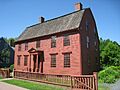
Joseph Webb House in Wethersfield, Connecticut, in 2009
-
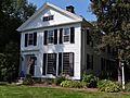
Asa Barnes Tavern/Levi B. Frost House in Southington, Connecticut, in 2011


