
List of islands within the Murray River in South Australia facts for kids
The Murray River is Australia's longest river, and it flows through South Australia before reaching the ocean. Along its path, especially near its mouth and in the lakes it connects to, you can find many interesting islands! This list will take you on a journey to discover these islands, from the river's end at Encounter Bay all the way to where South Australia meets New South Wales and Victoria. We'll also explore islands in the nearby lakes: the Coorong, Lake Albert, and Lake Alexandrina.

Contents
Islands in the Coorong
The Coorong is a long, shallow lagoon system that runs parallel to the coast, connected to the Murray River mouth. It's a special place, and all the islands listed here are part of the Coorong National Park, protecting their unique environment. The islands are listed from west to east.
| Name | Location | Fun Facts |
|---|---|---|
| Sam Island | 35°44′42″S 139°14′31″E / 35.74496787°S 139.24189437°E | |
| Needles Island | 35°50′39″S 139°21′17″E / 35.84407827°S 139.35480084°E | |
| Goat Island | 35°50′50″S 139°20′52″E / 35.84723052°S 139.34768843°E | |
| Snake Island | 35°51′02″S 139°21′57″E / 35.850670°S 139.365840°E | |
| Rabbit Island | 35°51′37″S 139°22′42″E / 35.860210°S 139.3784°E | |
| Bluff Island | 35°53′03″S 139°23′22″E / 35.884060°S 139.3895°E | |
| Bull Island | 35°54′56″S 139°25′18″E / 35.915620°S 139.421670°E | |
| Cow Island | 35°55′52″S 139°27′03″E / 35.93104990°S 139.45079703°E | |
| Long Island | 35°56′08″S 139°27′27″E / 35.935640°S 139.457560°E | |
| Round Island | 35°56′28″S 139°27′44″E / 35.941030°S 139.462180°E | |
| Swan Island | 35°56′40″S 139°28′09″E / 35.944510°S 139.469190°E | |
| Stony Well Island | 35°57′44″S 139°29′28″E / 35.962280°S 139.491090°E | |
| Cattle Island | 36°00′25″S 139°32′04″E / 36.00705859°S 139.53448578°E | |
| Teal Island | 36°02′13″S 139°33′30″E / 36.036880°S 139.558470°E | |
| North Pelican Island | 36°02′40″S 139°33′31″E / 36.04435402°S 139.55871543°E | |
| Halfway Island | 36°03′06″S 139°34′01″E / 36.05166457°S 139.56690284°E | |
| Pelican Island | 36°03′27″S 139°33′48″E / 36.057460°S 139.563460°E | |
| Mellor Island | 36°04′06″S 139°34′30″E / 36.068370°S 139.574870°E | |
| Seagull Island | 36°05′03″S 139°35′25″E / 36.084270°S 139.590410°E | |
| Wild Dog Island | 36°07′24″S 139°37′41″E / 36.123280°S 139.627990°E |
Islands in Lake Albert
Lake Albert is a freshwater lake connected to Lake Alexandrina. It has one main island.
| Name | Location | Fun Facts |
|---|---|---|
| Bascombe Island | 35°43′35″S 139°15′49″E / 35.72648039°S 139.26348163°E | This island is found in a bay at the southern end of the lake, called Bascombe Bay. |
Islands in Lake Alexandrina
Lake Alexandrina is a large freshwater lake where the Murray River spreads out before reaching the ocean. Many islands are found here, especially near the southern end.
| Name | Location | Fun Facts |
|---|---|---|
| Goose Island | 35°29′30″S 138°49′53″E / 35.49172152°S 138.83152770°E | This island was covered by water when barrages (special dams) were built in the 1930s to control water levels. It's part of the Currency Creek Game Reserve. |
| Billygoat Islands | 35°29′18″S 138°50′11″E / 35.48844308°S 138.83643637°E | This is a group of small islands. Many of them were also covered by water after the barrages were built. They are also within the Currency Creek Game Reserve. |
| Reedy Island | 35°31′53″S 138°50′39″E / 35.531270°S 138.844230°E | Located in the Goolwa Channel, south of Hindmarsh Island, and within the Coorong National Park. |
| Rushy Island | 35°32′08″S 138°50′59″E / 35.535440°S 138.849680°E | Also in the Goolwa Channel, south of Hindmarsh Island, and part of the Coorong National Park. |
| Hindmarsh Island | 35°30′58″S 138°52′34″E / 35.51618332°S 138.87616566°E | This is a well-known island in the lake. |
| Bird Island | 35°33′10″S 138°53′44″E / 35.55288311°S 138.89542664°E | Found in the Coorong Channel, south of Hindmarsh Island, and within the Coorong National Park. It's also known as Gull Island. |
| Varcoe Island | 35°32′31″S 138°54′04″E / 35.541960°S 138.901010°E | Located in the Mundoo Channel, between Hindmarsh and Mundoo Islands. |
| Lucerne Island | 35°31′54″S 138°55′31″E / 35.53156940°S 138.92519926°E | |
| Mundoo Island | 35°32′47″S 138°56′02″E / 35.546510°S 138.9339°E | |
| Goose Island | 35°30′05″S 138°56′09″E / 35.50127164°S 138.93570995°E | Located east of the town of Clayton Bay. |
| Goat Island | 35°30′15″S 138°56′37″E / 35.504110°S 138.943560°E | Also located east of Clayton Bay. |
| Ewe Island | 35°33′23″S 138°56′49″E / 35.556260°S 138.947020°E | In 1877, this island and Long Island were thought to be one island called Reedy Island. |
| Rat Island | 35°31′13″S 138°57′33″E / 35.520140°S 138.959110°E | Sometimes called Ram Island. |
| Long Island | 35°32′15″S 138°59′06″E / 35.537480°S 138.98487346°E | Also known as Ram Island and Grindstone Island. Like Ewe Island, it was once considered part of a larger Reedy Island. |
| Tauwitchere Island | 35°34′28″S 138°59′22″E / 35.574560°S 138.989540°E | This island has an area of about 144 hectares (356 acres). It's also known by names like Towagery and Talwadjeri Island. |
| Myrtle Island | 35°34′08″S 138°59′32″E / 35.5689°S 138.992280°E | Found within the Mud Islands Game Reserve. |
| Snake Island | 35°33′41″S 138°59′49″E / 35.56143004°S 138.99698025°E | |
| Mud Island | 35°33′51″S 139°00′43″E / 35.564130°S 139.011910°E | This island is about 17 hectares (43 acres) and is part of the Mud Island Game Reserve. |
| Reedy Island No 2 | 35°33′22″S 139°00′43″E / 35.5560°S 139.012070°E | |
| Pomanda Island | 35°24′58″S 139°18′29″E / 35.41600826°S 139.30799221°E | Located just south of where the Murray River flows into Lake Alexandrina. |
Islands from Wellington to Morgan
This section lists islands found in the main channel of the Murray River, moving from the town of Wellington north to the town of Morgan.
| Name | Location | Fun Facts |
|---|---|---|
| Miss Gawler Island | 35°08′50″S 139°18′35″E / 35.14728707°S 139.30978°E | This island is located southeast of Murray Bridge and sits right under the Swanport Bridge. |
| Long Island | 35°07′48″S 139°17′59″E / 35.130070°S 139.299730°E | This island is directly opposite Murray Bridge and is part of the Long Island Recreation Park. The Ngarrindjeri people, who are the traditional owners of this land, consider this island to be very important culturally. |
| Nott Island | 34°22′44″S 139°37′30″E / 34.37875552°S 139.62503174°E | Located about 3 kilometers (2 miles) south of the town of Blanchetown. |
| Reedy Island | 34°17′43″S 139°38′12″E / 34.29535698°S 139.63662083°E | About 7 kilometers (4 miles) north of Blanchetown, it's across the river from the Roonka Conservation Park and just south of Julia Island. |
| Julia Island | 34°17′30″S 139°38′24″E / 34.291560°S 139.639870°E | Right next to Reedy Island and also across the river from the Roonka Conservation Park. |
Islands from Morgan to the Border
This section covers islands in the Murray River channel from the town of Morgan all the way to the borders with New South Wales and Victoria.
| Name | Location | Fun Facts |
|---|---|---|
| Hart Island | 34°10′33″S 140°03′17″E / 34.17590386°S 140.05461270°E | East of Waikerie. It used to be called Wigleys Island and has been known by its current name since at least 1888, possibly named after a pastoralist (someone who raises livestock) named J. Hart. |
| Sandy Island | 34°10′57″S 140°05′04″E / 34.182510°S 140.084360°E | This island was shown on an atlas from 1877, but as of 2015, it wasn't on "current mapping." |
| Ball Island | 34°10′59″S 140°20′27″E / 34.183180°S 140.340790°E | |
| Thurk Island | 34°13′05″S 140°22′02″E / 34.21804118°S 140.36710836°E | East of Kingston-on-Murray and across from the Loch Luna Game Reserve. It was once known as Chambers Island. |
| Moorook Island | 34°17′13″S 140°22′12″E / 34.28693766°S 140.36996279°E | Located opposite the town of Moorook. Also known as Moorook Isle or Moorik Isle. |
| Nynes Island | 34°19′58″S 140°23′11″E / 34.33285356°S 140.38643302°E | Previously known as Pyap Island. |
| Forbys Island | 34°26′36″S 140°30′00″E / 34.44320925°S 140.50006195°E | |
| Katarapko Island | 34°24′20″S 140°33′22″E / 34.40566248°S 140.55608657°E | This island is part of the Murray River National Park. It used to be called Cragg Island. |
| Kapunda Island | 34°26′54″S 140°33′36″E / 34.44846740°S 140.55998258°E | Located northwest of Loxton and within the Kapunda Island Conservation Park. In 1994, it was reported to be about 1 hectare (2.5 acres) in size and only reachable by boat. |
| Rilli Island | 34°23′37″S 140°34′40″E / 34.39356053°S 140.57769733°E | Part of the Rilli Island Conservation Park. It was also known as Riley Island. In 1994, it was about 4 hectares (10 acres) and usually only accessible by boat, unless the river was very low, then you could walk to it from the south bank. |
| Media Island | 34°25′46″S 140°35′17″E / 34.429540°S 140.588180°E | Southeast of Loxton and within the Media Island Conservation Park. It was called Medea Island. In 1994, it was about 1 hectare (2.5 acres) and also mostly accessible by boat, or by foot during low river flows. |
| Punkey Island | 34°15′15″S 140°42′24″E / 34.25412471°S 140.70654564°E | Also known as Penky Island. |
| Cemlell Island | 34°14′20″S 140°42′27″E / 34.238870°S 140.707420°E | Also known as Gumlell Island. |
| Muklemuk Island | 34°14′11″S 140°43′52″E / 34.236460°S 140.731150°E | Also known as Muckle Muk Island. |
| Reny Island | 34°03′33″S 140°44′09″E / 34.05910722°S 140.73577007°E | |
| Nelbuck Island | 34°06′05″S 140°44′47″E / 34.10144157°S 140.74633239°E | This island is next to Bulyong Island and was officially named in 1996 by the Minister of Environment. |
| Nelwart Island | 34°12′55″S 140°44′56″E / 34.215280°S 140.749°E | Also called Nelwart Island. |
| Goat Island | 34°11′14″S 140°45′08″E / 34.18720150°S 140.75220533°E | |
| Bulyong Island | 34°07′21″S 140°45′51″E / 34.122540°S 140.764160°E | This island is part of the Murray River National Park. |
| Kylie Island | 34°08′12″S 140°45′51″E / 34.13679281°S 140.76420893°E | Its name comes from the last name of the people who owned the land. |
| Causeway Island | 34°10′08″S 140°45′56″E / 34.168880°S 140.765420°E | |
| Longwang Island | 34°08′53″S 140°46′15″E / 34.14815204°S 140.77084040°E | |
| Sandy Island | 34°15′20″S 140°47′34″E / 34.255650°S 140.7927°E | Also known as Sandy Ridge. |
| Hunchee Island | 34°03′07″S 140°47′36″E / 34.051840°S 140.7933°E | |
| Little Hunchee Island | 34°01′57″S 140°49′28″E / 34.03257899°S 140.82436519°E | Part of the Chowilla Game Reserve. |
| Chowilla Island | 33°59′19″S 140°52′44″E / 33.98870183°S 140.87895483°E | Located within the Chowilla Game Reserve. |
| Monoman Island | 33°59′19″S 140°52′44″E / 33.98870183°S 140.87895483°E | Also located within the Chowilla Game Reserve. |
| Reedy Island | 33°57′51″S 140°54′15″E / 33.964280°S 140.9043°E | Found within the Chowilla Game Reserve. |
| Boat Creek Island | 33°57′09″S 140°54′45″E / 33.952530°S 140.912580°E | Located within the Chowilla Game Reserve. |
| Slaney Island | 33°57′00″S 140°55′51″E / 33.949990°S 140.930850°E | Part of the Chowilla Game Reserve. Also known as Stanley Island. |
| Newena Island | 33°57′44″S 140°55′55″E / 33.96218883°S 140.93196606°E | Located within the Chowilla Game Reserve; also called the Isle of Man. |
| Punkah Island | 33°56′45″S 140°58′04″E / 33.945940°S 140.967860°E | Found within the Chowilla Game Reserve. |
| Wilpena Island | 33°59′50″S 140°59′00″E / 33.99718402°S 140.98329388°E | Located within the Chowilla Game Reserve. |
| Grand Junction Island | 33°58′50″S 140°59′22″E / 33.980640°S 140.989340°E | Part of the Chowilla Game Reserve. |
| Hypurna Island | 34°00′12″S 140°59′57″E / 34.00344271°S 140.99915737°E | This island is partly in the Chowilla Game Reserve and also sits right on the border with New South Wales. |
Images for kids
-
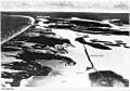
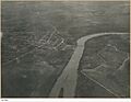
Aerial view from the east showing island system adjoining Murray Mouth including locations of barrages (State Library of South Australia - PRG-1258/2/546)
-
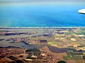
Aerial photo of Goolwa, South Australia with Hindmarsh Island on the left side of image
-
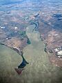
Pomanda Island (at bottom of image)
-
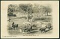
Cattle grazing at Long Island, circa 1900 (State Library of South Australia (B 26826)
-
Aerial view of Murray Bridge from the south including the north end of Long Island, circa 1920 (State Library of South Australia B 11533)
-
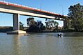
Miss Gawler Island is located below the Swanport Bridge
-
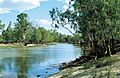
Hunchee Island viewed from Headings Cliff on the opposite of the Murray River.
-
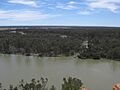
Katarapko Island as viewed from Loxton.
-
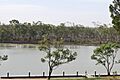
View of Punkah Creek showing both Punkah Island and the mainland.


.jpg)
.jpeg)


See also
- List of islands of Australia
- List of islands in lakes
