Londonderry (CDP), New Hampshire facts for kids
Quick facts for kids
Londonderry, New Hampshire
|
|
|---|---|

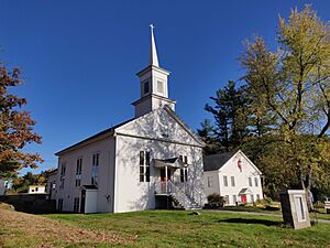
Londonderry United Methodist Church
|
|
| Country | United States |
| State | New Hampshire |
| County | Rockingham |
| Town | Londonderry |
| Area | |
| • Total | 12.24 sq mi (31.71 km2) |
| • Land | 12.22 sq mi (31.65 km2) |
| • Water | 0.02 sq mi (0.06 km2) |
| Elevation | 250 ft (80 m) |
| Population
(2020)
|
|
| • Total | 11,645 |
| • Density | 953.02/sq mi (367.96/km2) |
| Time zone | UTC-5 (Eastern (EST)) |
| • Summer (DST) | UTC-4 (EDT) |
| ZIP codes |
03038, 03053
|
| Area code(s) | 603 |
| FIPS code | 33-43140 |
| GNIS feature ID | 2378079 |
Londonderry is a special area called a census-designated place (CDP) in the town of Londonderry, located in Rockingham County, New Hampshire, United States. A CDP is like a specific neighborhood or part of a town that the government counts separately for population. In 2020, about 11,645 people lived in this part of Londonderry. The entire town of Londonderry had a population of 25,826 people.
Contents
Where is Londonderry?
The Londonderry CDP is in the eastern and southern parts of the larger town of Londonderry. It includes the historic town center on Moose Hill. The town offices are within the CDP. However, the Londonderry High School and Middle School are just outside its western border.
The CDP shares borders with other towns. To the east, it borders Derry. To the southeast, it borders Windham. To the southwest, it borders Hudson.
Roads and Connections
Several important roads run through Londonderry. New Hampshire Route 102 crosses the CDP. It leads northeast about 3 miles (5 km) to the center of Derry. It also goes southwest about 7 miles (11 km) to Hudson.
New Hampshire Route 128 is another key road. It goes north about 5 miles (8 km) to New Hampshire Route 28 in North Londonderry. It also travels south about 16 miles (26 km) to Lowell, Massachusetts. If you want to go to Manchester, it's about 12 miles (19 km) north using Routes 128 and 28.
Land and Water
The Londonderry CDP covers an area of about 12.2 square miles (31.7 square kilometers). Most of this area is land. Only a small part, about 0.02 square miles (0.06 square kilometers), is water.
Most of the water in the CDP flows southeast into Beaver Brook. This brook forms the border with Windham. It then flows south to the Merrimack River in Lowell, Massachusetts. A small part of the CDP in the southwest drains into Chase Brook. This brook flows west to the Merrimack River in Litchfield.
Who Lives in Londonderry?
A census is a count of the population. The U.S. Census Bureau collects this information.
| Historical population | |||
|---|---|---|---|
| Census | Pop. | %± | |
| 1990 | 10,114 | — | |
| 2000 | 11,417 | 12.9% | |
| 2010 | 11,037 | −3.3% | |
| 2020 | 11,645 | 5.5% | |
| U.S. Decennial Census | |||
In 2010, there were 11,037 people living in the Londonderry CDP. These people lived in 3,958 households. About 3,098 of these were families.
Population Details
Most people in the CDP were white, making up about 95.8% of the population in 2010. Other groups included African American (0.8%), Native American (0.1%), and Asian (1.5%). About 2.5% of the population identified as Hispanic or Latino.
Many households had children under 18 living with them (39.9%). Most families were headed by married couples (62.8%). About 16.4% of households were made up of people living alone. The average household had about 2.79 people.
The median age in Londonderry was 41.3 years in 2010. This means half the people were younger than 41.3, and half were older. About 25.6% of residents were under 18 years old. About 10.3% were 65 years or older.
Income and Economy
From 2011 to 2015, the estimated average yearly income for a household was about $89,643. For families, the average income was around $97,386. The average income per person was about $38,835.
A small percentage of the population lived below the poverty line. This included 3.6% of all people and 2.0% of families. Among those under 18, 5.4% were below the poverty line. For people 65 or older, 2.8% were below the poverty line.
See also
 In Spanish: Londonderry (condado de Rockingham) para niños
 | John T. Biggers |
 | Thomas Blackshear |
 | Mark Bradford |
 | Beverly Buchanan |


