
Louisiana Purchase State Park facts for kids
Quick facts for kids Louisiana Purchase State Park |
|
|---|---|

Louisiana Purchase State Park sign at the boardwalk
|
|
| Location | Eastern Arkansas |
| Nearest city | Brinkley, Arkansas |
| Area | 37.5 acres (15.2 ha) |
| Established | 1961 |
| Governing body | Arkansas Department of Parks, Heritage, and Tourism |
| Official name: Louisiana Purchase Survey Marker | |
| Designated | February 23, 1972 |
| Reference no. | 72000206 |
| Official name: Beginning Point of the Louisiana Purchase Land Survey | |
| Designated | April 19, 1993 |
| Lua error in Module:Location_map at line 420: attempt to index field 'wikibase' (a nil value). | |
The Louisiana Purchase State Park is a special place in eastern Arkansas. It marks the exact spot where surveyors began measuring all the new land the United States bought in the famous Louisiana Purchase of 1803. This huge land deal doubled the size of the country! The park helps us remember this important moment in history.
The park protects about 37.5 acres of forested wetlands, which are like swamps. These types of lands are becoming rare because they are often drained for farming. At the survey point, there is a 6-foot (1.8 m) tall stone marker. The Daughters of the American Revolution (D.A.R.) placed it there in 1926. This site became a National Historic Place in 1972 and a National Historic Landmark in 1993.
Contents
Discovering the Louisiana Purchase Park
The Louisiana Purchase State Park is found in eastern Arkansas, near a town called Blackton. It sits where three counties meet: Lee, Monroe, and Phillips. This park protects about 37.5 acres of a unique type of forest called a swamp or forested wetland.
Exploring the Swamp and Boardwalk
This swamp looks much like it did in 1815 when the first surveyors arrived. These wetlands are special because many have been cleared for farms. A long boardwalk, about 950 feet (290 m) long, helps visitors explore the park. Along the way, signs explain the plants and animals of the area. They also share why this spot is so important to history.
The Historic Survey Marker
The D.A.R. Louisiana Purchase Survey Marker is a tall stone monument. It stands about 6 feet (1.8 m) high and is 4.5 feet (1.4 m) wide at its base. It often stands in about 1 foot (0.3 m) of swamp water. The words on the marker tell us: "This stone marks the base established November 10, 1815, from which the lands of the Louisiana Purchase were surveyed by United States engineers. The first survey from this point was made to satisfy the claims of the soldiers of the War of 1812 with land bounties."
History of the Louisiana Purchase Point
How the United States Grew
On April 30, 1803, the United States bought a massive amount of land from France. This deal, called the Louisiana Purchase, added 830,000 square miles (2,100,000 sq km) to the country. It stretched west of the Mississippi River and nearly doubled the size of the young United States. President Thomas Jefferson then sent the Lewis and Clark Expedition to explore this new territory.
The Important 1815 Land Survey
After the War of 1812, President James Monroe ordered a survey of the new land. This was to help give land to soldiers who had fought in the war. Two teams of surveyors, led by Prospect K. Robbins and Joseph C. Brown, were tasked with finding a starting point.
Robbins' team traveled north from the Arkansas River. Brown's team traveled west from the St. Francis River. On October 27, 1815, the two teams met at this exact spot. This meeting point became the official starting place for all future surveys of the Louisiana Purchase lands. It was named the Fifth Principal Meridian.
Challenges of the Early Survey
Robbins' team faced a tough journey, traveling 55 miles (89 km) through difficult swampy land. Brown's team traveled 26 miles (42 km) through areas that were sometimes good for farming and sometimes full of thick bushes. They marked two trees to show where their survey lines met.
Rediscovering a Lost Landmark
Over the years, the exact starting point of the survey was forgotten. But in 1921, surveyors working between Phillips and Lee counties rediscovered the marked trees. The L'Anguille Chapter of the Daughters of the American Revolution (D.A.R.) in Marianna, Arkansas, then worked to honor the spot. They placed the stone marker there, and it was dedicated on October 27, 1926. This was 111 years after the original survey point was established.
Creating the State Park
In 1961, Arkansas officially made the area a state park. However, no money was set aside to buy land or build facilities at first. Later, the Arkansas Natural Heritage Commission helped buy the 37.5 acres that make up the park today. They also made sure the land would be protected and kept natural.
Gallery
-
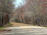
Entrance to the park on State Highway 362.
-
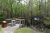
Footpath leading to the boardwalk.
-
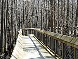
Boardwalk leading to the site.
-
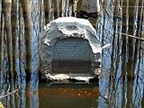
Louisiana Purchase Survey Marker.


See also
