Lovell, Wyoming facts for kids
Quick facts for kids
Lovell, Wyoming
|
|
|---|---|

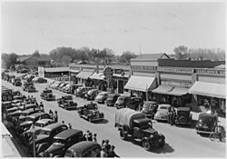
Parade of vehicles from Civilian Conservation Corps Camp BR-7 in Lovell, Wyoming
|
|
| Nickname(s):
Rose Town of Wyoming
|
|
| Motto(s):
"The Rose City"
|
|

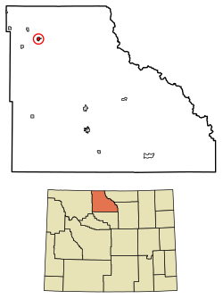
Location of Lovell in Big Horn County, Wyoming.
|
|
| Country | United States |
| State | Wyoming |
| County | Big Horn |
| Area | |
| • Total | 1.10 sq mi (2.85 km2) |
| • Land | 1.10 sq mi (2.85 km2) |
| • Water | 0.00 sq mi (0.00 km2) |
| Elevation | 3,832 ft (1,168 m) |
| Population
(2020)
|
|
| • Total | 2,243 |
| • Density | 2,035.4/sq mi (785.9/km2) |
| Time zone | UTC-7 (Mountain (MST)) |
| • Summer (DST) | UTC-6 (MDT) |
| ZIP code |
82431
|
| Area code(s) | 307 |
| FIPS code | 56-47950 |
| GNIS feature ID | 1591067 |
| Website | Town of Lovell, Wyoming |
Lovell is the biggest town in Big Horn County, Wyoming, in the United States. In 2020, about 2,243 people lived there. It's known as the "Rose Town of Wyoming."

Contents
History of Lovell
Lovell was named after Henry Lovell. He was a rancher who lived in the area.
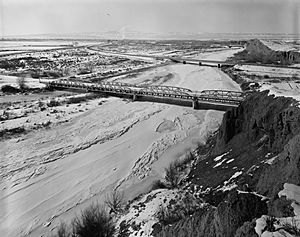
A special bridge, the EJZ Bridge over Shoshone River, was built in 1925. This bridge is now listed on the National Register of Historic Places. This means it is an important historical site.
Geography and Climate
Where is Lovell?
Lovell is located in Wyoming. Its exact coordinates are 44.836787 degrees North and -108.392180 degrees West.
The town covers a total area of about 1.10 square miles (2.85 square kilometers). All of this area is land.
Lovell's Weather
Lovell has a desert climate. This means it gets very little rain. Winters are cold and dry. Summers are hot and a bit wetter.
| Climate data for Lovell, Wyoming | |||||||||||||
|---|---|---|---|---|---|---|---|---|---|---|---|---|---|
| Month | Jan | Feb | Mar | Apr | May | Jun | Jul | Aug | Sep | Oct | Nov | Dec | Year |
| Record high °F (°C) | 63 (17) |
71 (22) |
78 (26) |
88 (31) |
97 (36) |
103 (39) |
106 (41) |
105 (41) |
99 (37) |
89 (32) |
72 (22) |
66 (19) |
106 (41) |
| Mean daily maximum °F (°C) | 29.1 (−1.6) |
37.7 (3.2) |
48.9 (9.4) |
59.0 (15.0) |
68.3 (20.2) |
78.7 (25.9) |
86.6 (30.3) |
85.5 (29.7) |
73.6 (23.1) |
60.5 (15.8) |
43.4 (6.3) |
31.9 (−0.1) |
58.6 (14.8) |
| Daily mean °F (°C) | 16.9 (−8.4) |
24.8 (−4.0) |
35.7 (2.1) |
45.1 (7.3) |
54.9 (12.7) |
64.2 (17.9) |
70.5 (21.4) |
68.7 (20.4) |
57.1 (13.9) |
45.6 (7.6) |
31.0 (−0.6) |
19.9 (−6.7) |
44.5 (7.0) |
| Mean daily minimum °F (°C) | 4.7 (−15.2) |
11.9 (−11.2) |
22.4 (−5.3) |
31.2 (−0.4) |
41.5 (5.3) |
49.7 (9.8) |
54.3 (12.4) |
51.8 (11.0) |
40.6 (4.8) |
30.6 (−0.8) |
18.6 (−7.4) |
7.8 (−13.4) |
30.4 (−0.9) |
| Record low °F (°C) | −39 (−39) |
−35 (−37) |
−20 (−29) |
7 (−14) |
18 (−8) |
30 (−1) |
38 (3) |
32 (0) |
17 (−8) |
−8 (−22) |
−27 (−33) |
−38 (−39) |
−39 (−39) |
| Average precipitation inches (mm) | 0.24 (6.1) |
0.16 (4.1) |
0.33 (8.4) |
0.59 (15) |
1.21 (31) |
0.99 (25) |
0.75 (19) |
0.60 (15) |
0.75 (19) |
0.65 (17) |
0.24 (6.1) |
0.23 (5.8) |
6.74 (171.5) |
| Source 1: NOAA (normals, 1971–2000) | |||||||||||||
| Source 2: The Weather Channel (Records) | |||||||||||||
People of Lovell
Population Changes Over Time
| Historical population | |||
|---|---|---|---|
| Census | Pop. | %± | |
| 1910 | 699 | — | |
| 1920 | 1,686 | 141.2% | |
| 1930 | 1,857 | 10.1% | |
| 1940 | 2,175 | 17.1% | |
| 1950 | 2,508 | 15.3% | |
| 1960 | 2,451 | −2.3% | |
| 1970 | 2,371 | −3.3% | |
| 1980 | 2,447 | 3.2% | |
| 1990 | 2,131 | −12.9% | |
| 2000 | 2,281 | 7.0% | |
| 2010 | 2,360 | 3.5% | |
| 2020 | 2,243 | −5.0% | |
| 2023 (est.) | 2,350 | −0.4% | |
| U.S. Decennial Census | |||
In 2010, about 2,360 people lived in Lovell. The town had 909 households. Most people were White (94.0%). About 10.8% of the population was Hispanic or Latino.
Age and Families
The average age of people in Lovell was 36 years old. About 27.4% of residents were under 18. Also, 19.3% were 65 years or older.
Many households (51.5%) were married couples living together. About 33.6% of households had children under 18.
Things to See and Do
Fun Places to Visit
Lovell is close to several interesting places:
- Bighorn Canyon National Recreation Area
- Big Horn Mountains
- Big Horn River
- Buffalo Bill Historical Center
- Hyart Theater
- Queen Bee Gardens
Education in Lovell
Schools and Learning
Students in Lovell attend schools run by Big Horn County School District #2.
- Lovell Elementary School is for grades K-5.
- Lovell Middle School is for grades 6-8.
- Lovell High School is for grades 9-12.
Lovell also has a public library. It is part of the Big Horn County Library System.
Media and News
Local Radio and TV
Lovell has its own radio station, KWHO (107.1 FM).
You can also watch several TV stations in Lovell. These include KTVQ (CBS), KULR (NBC), and KCWC-DT (PBS).
Famous People from Lovell
Some notable people have come from Lovell:
- Don G. Despain (born 1940), a scientist who studies plants and nature.
- Richard Kermode (1946–1996), a keyboard player for the band Santana.
See also
 In Spanish: Lovell (Wyoming) para niños
 | Emma Amos |
 | Edward Mitchell Bannister |
 | Larry D. Alexander |
 | Ernie Barnes |


