Lower Prospect Canal Reserve facts for kids
Quick facts for kids Lower Prospect Canal Reserve |
|
|---|---|
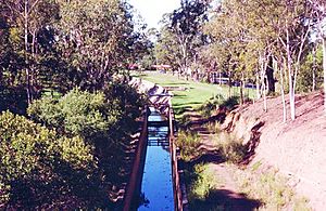
The canal within the bushland corridor.
|
|
| Lua error in Module:Location_map at line 420: attempt to index field 'wikibase' (a nil value). | |
| Type | Woodland, urban park, urban forest, nature reserve |
| Location | Cumberland Council |
| Area | 546 hectares (1,349.20 acres) |
| Owned by | Cumberland Council |
| Status | Open all year |
| Official name | Lower Prospect Canal Reserve; Lower Canal; Boothtown Aqueduct; Inverted Syphon; Aqueduct Valve House No 1 & 2 and Culvert; Covered Way; Smithfield Tanks; Sedimentation Channel |
| Type | State heritage (built) |
| Designated | 30 June 2015 |
| Reference no. | 1945 |
| Type | Irrigation Channel/Canal |
| Category | Utilities – Water |
| Builders | NSW Board of Water Supply and Sewerage; Kinchela and Metcalfe |
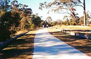
The Lower Prospect Canal Reserve is a special place in Sydney, New South Wales, Australia. It used to be a farm and a public water supply canal. Now, it's a long, green corridor and nature reserve that stretches about 7.7 kilometres (4.8 miles).
This reserve runs through the middle of Sydney's suburbs. It goes from Prospect Reservoir all the way to Sydney Water Pipehead in Guildford. Most of the reserve is in Greystanes, which is part of the Cumberland Council area.
The Canal Reserve is one of the last remaining parts of the natural Cumberland Plain Woodland in Sydney. This woodland is a special type of forest. It has many rare and endangered plants. The local government protects this land for conservation. The Lower Prospect Canal used to supply water to western Sydney. But in 1995, a new underground pipeline was built. This meant the old canal was no longer needed for water supply.
The whole water system worked using gravity. This meant it had to be built very precisely. The Lower Prospect Canal drops only about 77 centimetres (30 inches) over its entire 7.7-kilometre length. Edward Orpen Moriarty designed the system, including this canal. It was built between 1880 and 1888. The reserve is also known by other names, like Lower Canal and Boothtown Aqueduct. It is owned by the government and was added to the New South Wales State Heritage Register in 2015.
Contents
History of the Canal Reserve
Why the Canal Was Built
In the 1860s, Sydney's population was growing fast, and there were droughts. People needed a bigger and more reliable source of water. In 1869, a special group suggested building the Upper Nepean Scheme. This big project was approved in 1877, and work began in 1880.
The canal was first built using dry-stone masonry in 1888. This means stones were carefully placed without mortar. From 1902 to 1912, it was rebuilt and lined to stop water from leaking. This also helped it carry more water. A part of the canal called the Covered Way collapsed in 1904. It was rebuilt in 1905. The Covered Way protected the water supply from getting dirty. This was important because it was near a steep hill called Prospect Hill.
Changes Over Time
By the late 1980s, the Lower Canal couldn't keep up with Sydney's growing need for water. Even after changes, it could only carry 100 million gallons of water per day. Also, people wanted cleaner water and a more secure supply. The open canal was becoming a problem as urban areas grew around it.
The Upper Nepean Scheme brought water from several rivers. This water traveled through tunnels, pipes, and open canals to Prospect Reservoir. From there, the water went through the Lower Prospect Canal. This is the same path as the reserve today. In May 1995, the canal was drained and replaced. A new underground pipeline now carries water from Prospect Reservoir. This pipeline provides more reliable, cleaner water.
From Canal to Reserve
After the canal was no longer used for water, it became a public reserve in 1998. This allowed the community to use this amazing piece of land for fun. The reserve has survived a lot of building around it. This is because it was used for over 100 years as part of Sydney's water system. In August 2003, the reserve officially opened to the public. It now has a cycleway and walkway along its entire length. This path connects to other cycleways across Sydney.
Geography of the Reserve
The reserve is a bit over 6.6 kilometres (4.1 miles) long. It starts at Reconciliation Road in Pemulwuy. It then goes through Greystanes, Smithfield, Merrylands, and Woodpark. It ends at Pipehead in Guildford.
The Lower Canal follows a natural ridge. It slowly drops from west to east. The western end is about 60-70 metres (197-230 feet) above sea level. It falls to about 40 metres (131 feet) at the eastern end. Three roads cross over the canal with bridges: Gipps Road, Cumberland Highway, and Sherwood Road. Homes are built on both sides of the reserve. There are also light industries near Smithfield. The canal is now surrounded by managed nature reserves.
Canal Road Park is on the western side of Greystanes. It's on a high ridge, offering great views of southwestern Sydney. This park has a children's playground, BBQ area, and picnic shelters.
How the Canal Was Built
Canal Design and Features
The canal was designed for water to flow by gravity. It had a slight slope of about 10 centimetres (3.9 inches) for every kilometre. The top width of the canal was between 5.8 and 7.25 metres (19 and 23.8 feet). Its depth was between 2.4 and 3 metres (7.9 and 9.8 feet).
About 1 kilometre (0.62 miles) east of Prospect Reservoir, the canal went underground for 288 metres (945 feet). This was done to protect the water from dirt and pollution. This section was cut through Prospect Hill.
At the start of the canal, near Prospect Reservoir, there are valve houses. These houses have pipes that let water flow from the reservoir into the canal. Valves inside the valve house controlled this water flow. At the very end of the canal, before it reached Pipehead, there were two sedimentation chambers. These chambers trapped dirt from the water. This made the water cleaner before it entered the Pipehead pumphouse.
On the south side of the canal, near Percival Road, there are two old tanks. The first was built in 1895. These tanks supplied water to Smithfield. Today, these tanks are hard to find because they are covered by plants. The top 150 millimetres (5.9 inches) of the canal wall were left open. This lets visitors see the canal's path. It also creates a clear view between the bushland and the path.
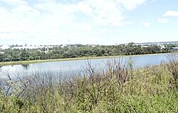
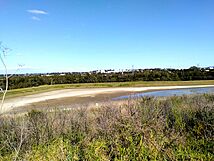
A detention basin called Widemere Detention Basin is north of Wetherill Park. It collects stormwater runoff. If there's not too much rain, the water stays in the basin. If it rains a lot, the extra water flows into Prospect Creek. The water levels in the basin are watched carefully. This makes sure there's always room for heavy rainfall. The water in the basin is usually recycled.
Major Changes to the Canal
Here are some important changes made to the canal over the years:
- 1895 – Smithfield Tanks (reservoirs) were built to supply water to Smithfield.
- 1902–1912 – The canal was relined with concrete. This increased its capacity by about 75%. The walls of the Smithfield Tank were also made taller.
- 1903 – Sedimentation Chambers were built west of Pipehead.
- 1905 – The Covered Way was rebuilt in concrete after it collapsed.
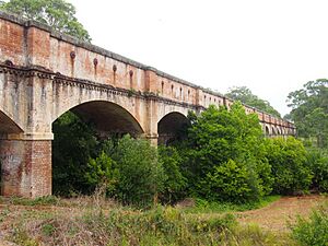
- 1907 – The Boothtown Aqueduct stopped being used. A new structure called an Inverted Syphon was built next to it.
- 1911 – The Gipps Road Bridge was built over the Lower Canal.
- 1995 – The Lower Canal was replaced by an underground pipeline. It was then emptied of water and no longer used for water supply.
- 2001 – Work began to turn the Lower Prospect Canal into a walking and cycling path. The canal walls were protected, and drainage was added. The canal was filled with concrete and soil layers. A pathway was built on top. The historical importance of the canal was considered during this work. The infilling can be reversed if needed.
- 2003 – The Lower Prospect Canal Reserve and its path officially opened.
- 2008 – A 100-metre (330 ft) section of the filled canal was removed. This was to build Reconciliation Road. The reserve now starts at Reconciliation Road.
Heritage Listing of the Reserve
The Lower Prospect Canal Reserve is a very important historical site. It was added to the New South Wales State Heritage Register in 1999. This means it's protected because of its special history and natural value.
The Lower Canal and its related structures are important because they were a key part of the Upper Nepean Scheme. This scheme was the first major engineering project in New South Wales to provide a good water supply for Sydney. It was Sydney's fourth water supply system, and the first reliable one. It was a huge step forward in how water was supplied. Instead of getting water from nearby, it was collected from distant rivers. This water was stored in dams and moved through channels, tunnels, and pipelines.
The Upper Nepean Scheme was one of the biggest engineering projects in Australia before 1888. It helped Sydney grow a lot. No other water supply canals like these have been built in New South Wales. The system was designed to be updated over time to meet Sydney's growing water needs. It still works today for its original purpose.
The Lower Canal was a vital part of the Upper Nepean Scheme for over 100 years. Even with many upgrades, its basic design stayed the same. It's a great example of 19th-century water engineering. It shows how gravity was used to supply water to a large area of Sydney. The canal also helps us learn about old building techniques. This includes the original stone work and later concrete upgrades. Even though it's filled in now, you can still see how it worked as a water supply.
Large parts of the Lower Prospect Canal Reserve have "Remnant Native Vegetation." This means it has original plants that are still there. This includes the Cumberland Plain Woodland, which is a critically endangered species. This woodland used to cover a huge area of Western Sydney. Now, only a small part of it remains. Protecting this woodland is very important.
Why it's Important for History
The Lower Canal shows how water supply systems developed in New South Wales. It was a key part of Sydney's first reliable water supply. This system was one of the biggest engineering projects in Australia before 1888. The Lower Canal worked for over 100 years. Even though it's now a park, you can still see its original purpose. The reserve also protects rare native plants, like the critically endangered Cumberland Plain Woodland.
Important People Involved
The Lower Canal is linked to the NSW Public Works Department and Sydney Water. The NSW Board of Water Supply and Sewerage was in charge of building the Upper Nepean Scheme and the Lower Canal. Edward Orpen Moriarty was the main engineer who designed and oversaw the Upper Nepean Scheme. He was a very important person in providing water supply in New South Wales. He had also worked on water supply projects for other towns.
Technical Achievements
The Lower Canal is important for its engineering skills. It shows how canals were built with very small slopes. It also shows engineering practices from the late 1800s and early 1900s. This was a time when most work was done by horses and people. It's a great example of how water was moved using gravity. Building hydraulic canals mostly stopped in the 20th century, as pressure pipelines became more common. This canal is one of the earliest examples in New South Wales of using large-scale precast reinforced concrete.
The Lower Canal has many different features. These include the filled-in open canal, an aqueduct, an inverted syphon, reservoirs, bridges, and sedimentation chambers. All these parts show the technology and engineering methods used back then. The fact that the concrete edges of the canal are still visible, along with other structures, helps us understand its original purpose.
Research Potential
The Lower Canal can help us learn a lot about old engineering methods. This includes its original stone construction, which is under the concrete lining. It also shows early uses of large-scale pre-cast reinforced concrete. The structures that are still there, like the Sedimentation Chambers and Smithfield Tank, offer chances for more study.
Rare and Unique Aspects
The Lower Canal is a key part of a rare and large water supply system in New South Wales. It was one of only two such open water supply canals in Australia. The other is the Upper Canal, which is part of the same scheme. The Lower Canal is the only part of the scheme that is no longer used for water. Because it's in an urban area and open to the public, it's a unique place to learn about the Upper Nepean Scheme.
Demonstrating Key Characteristics
The Lower Canal shows the main features of a large, engineered, and long-lasting urban water supply system. It also shows how such a system can be changed and improved over time.
 | Emma Amos |
 | Edward Mitchell Bannister |
 | Larry D. Alexander |
 | Ernie Barnes |


