
Lowndesboro, Alabama facts for kids
Quick facts for kids
Lowndesboro, Alabama
|
|
|---|---|

The Will Stone Store, (Est. 1820) in Lowndesboro.
|
|

Location of Lowndesboro in Lowndes County, Alabama.
|
|
| Country | United States |
| State | Alabama |
| County | Lowndes |
| Area | |
| • Total | 0.79 sq mi (2.05 km2) |
| • Land | 0.79 sq mi (2.05 km2) |
| • Water | 0.00 sq mi (0.00 km2) |
| Elevation | 404 ft (123 m) |
| Population
(2020)
|
|
| • Total | 89 |
| • Density | 112.37/sq mi (43.40/km2) |
| Time zone | UTC-6 (Central (CST)) |
| • Summer (DST) | UTC-5 (CDT) |
| ZIP code |
36752
|
| Area code(s) | 334 |
| FIPS code | 01-44536 |
| GNIS feature ID | 0163936 |
Lowndesboro is a small town in Lowndes County, Alabama, United States. In 2010, 115 people lived there. By 2020, the population had changed to 89. It is part of the larger Montgomery area.
Lowndesboro was first made an official town in 1856. However, it stopped being an official town for a while and was re-established in 1962. In 2000 and 2010, Lowndesboro was one of only two towns in Lowndes County where most residents were white. It is also one of the smallest communities in the county.
Contents
History of Lowndesboro
Early Settlement and Growth
Lowndesboro was first known as McGill's Hill. People started moving there after the Creek War ended. In 1832, the residents decided to change the town's name to Lowndesboro. They chose this name to honor William Lowndes, who was a U.S. Congressman. His father, Rawlins Lowndes, was an early governor of South Carolina.
The town grew quickly and became very successful by the 1830s. This was because it was close to the Alabama River, which was important for trade. Many wealthy farmers, known as planters, moved to the area. They built large, beautiful homes from the mid-1800s. Many of these old buildings are still standing today.
Lowndesboro During the Civil War
During the American Civil War, a small fight happened in Lowndesboro in April 1865. Soldiers from the Confederate army fought against advance troops of the Union Army. This happened during a military operation called Wilson's Raid.
After the fight, Union soldiers took over the town. Luckily, they caused very little damage. This helped to save many of the old homes and buildings in the Lowndesboro Historic District. These buildings were built before the Civil War.
After the War and Civil Rights Era
After the Civil War, Lowndesboro, like many small towns in the South, faced hard times. Its economy relied heavily on growing cotton. When the cotton trade declined, the town's growth slowed down. Because of this decline, many of the old buildings from before the war were not torn down or rebuilt. This makes Lowndesboro special today, as it has many well-preserved 19th-century buildings.
Today, much of the town is part of the Lowndesboro Historic District. This district is listed on the National Register of Historic Places, which means it's important to American history. The ruins of the Dicksonia Plantation are also a notable historical site nearby.
Lowndesboro also played a part in the civil rights movement. On March 25, 1965, a civil rights worker named Viola Liuzzo was killed near Lowndesboro. She was driving to Montgomery to pick up people who had marched from Selma. She was shot by members of the Ku Klux Klan.
In 1966, many African-American families in Lowndes County were forced out of their homes. This happened because they took part in the civil rights movement. Instead of leaving the area, twenty of these families set up a "tent city" just outside Lowndesboro. They lived in tents to show their determination.
Geography of Lowndesboro
Lowndesboro is located at coordinates 32°16′23″N 86°36′36″W / 32.27306°N 86.61000°W. The U.S. Census Bureau says that the town covers about 0.8 square miles (2.05 square kilometers) of land. There is no water area within the town limits.
Population Changes in Lowndesboro
| Historical population | |||
|---|---|---|---|
| Census | Pop. | %± | |
| 1850 | 500 | — | |
| 1880 | 472 | — | |
| 1970 | 219 | — | |
| 1980 | 207 | −5.5% | |
| 1990 | 139 | −32.9% | |
| 2000 | 140 | 0.7% | |
| 2010 | 115 | −17.9% | |
| 2020 | 89 | −22.6% | |
| U.S. Decennial Census 2013 estimate |
|||
Lowndesboro has appeared on the U.S. Census records at different times. It was listed in 1850 and 1880. In 1880, it was the largest town in Lowndes County, with 472 people. It did not appear on the census again until 1970.
According to the census in 2000, there were 140 people living in Lowndesboro. There were 58 households, and 40 of these were families. About 71% of the people were White, and 25% were Black or African American. A small number of people were from other racial backgrounds.
The average household had about 2.41 people, and the average family had about 2.98 people. About 27% of the population was under 18 years old, and about 24% was 65 years or older. The median age was 42 years.
Education in Lowndesboro
Lowndesboro has one private school:
- Lowndes Academy
Notable People from Lowndesboro
- Noble C. Powell: A well-known leader in the Episcopal Church in the United States of America.
- Rick Pate: He used to be the mayor of Lowndesboro. Now, he is a Commissioner for the Alabama Department of Agriculture and Industries.
Gallery
-
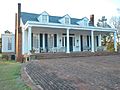
The Marengo House was built in 1847. It was taken apart, moved, and rebuilt in Lowndesboro in 1854. The Lowndesboro Town Hall moved into this building in 2011.
-
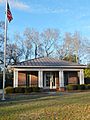
Lowndesboro Post Office (ZIP Code: 36752)
-
Meadowlawn Plantation was built in 1853. It is part of the Lowndesboro Historic District.
-
The C.M.E. Church in Lowndesboro was built in 1833. Its cupola (the small dome on top) came from Alabama's first state capitol building.
-

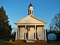
Lowndesboro Presbyterian Church was started in 1816. It is still an active church today.
-
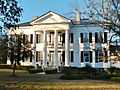
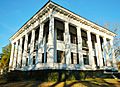
The Pillars is a large Greek Revival style home built in 1857. It was built by Archibald Tyson, a cotton planter.
-
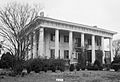
The Dicksonia Plantation was a beautiful Greek Revival mansion built in 1830. It was sadly destroyed by a fire in 1964.


See also
 In Spanish: Lowndesboro para niños
