Maatsuyker Island facts for kids

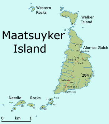
Detailed map of Maatsuyker Island
|
|
| Etymology | Joan Maetsuicker |
|---|---|
| Geography | |
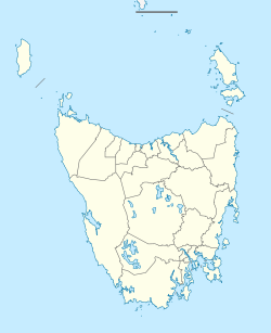
| Location | South West Tasmania |
| Coordinates | 43°39′00″S 146°16′12″E / 43.65000°S 146.27000°E |
| Archipelago | Maatsuyker Islands Group |
| Adjacent bodies of water | Southern Ocean |
| Area | 186 ha (460 acres) |
| Highest elevation | 284 m (932 ft) |
| Administration | |
|
Australia
|
|
| State | Tasmania |
| Region | South West |
| Demographics | |
| Population | A small number of volunteers |
Maatsuyker Island is a small island off the southern coast of Tasmania, Australia. It covers about 186 hectares, which is like 186 football fields! This island is part of a group called the Maatsuyker Islands Group. It is also part of the Southwest National Park and the Tasmanian Wilderness, which is a special World Heritage Site.
On the island's southern tip, you'll find the Maatsuyker Island Lighthouse. This lighthouse is the most southerly one in all of Australia! The island is also a very important place for birds. BirdLife International has named it an "Important Bird Area" because many seabirds come here to lay their eggs and raise their young.
Today, volunteers live on Maatsuyker Island for six months at a time. The Tasmanian Government and other volunteer groups help maintain the island and its historic lighthouse. They work to preserve the island's history.
Contents
Island Life: Plants and Animals
Island Plants: The Tea Tree Forest
Most of Maatsuyker Island is covered by a woody shrub called Leptospermum scoparium, also known as tea tree. In sheltered spots, these tea trees can grow up to 6 meters tall, forming a dense canopy.
Island Animals: Birds, Seals, and Reptiles
Maatsuyker Island is a busy place for many animals. It's especially important for seabirds that come here to breed.
Birds and Their Breeding Sites
Many types of seabirds use the island as a breeding ground. These include:
- Little penguins (about 700 pairs)
- Short-tailed shearwaters (a huge number, around 800,000 pairs!)
- Sooty shearwaters
- Fairy prions (about 5,000 pairs)
- Common diving petrels (around 10,000 pairs)
- Soft-plumaged petrels
Other birds you might see are the Pacific gull, silver gull, and sooty oystercatcher. A small mammal called the swamp antechinus has also been found here.
Seals and Reptiles
The island is a popular spot for seals. Australian fur seals use it as a place to rest on land. New Zealand fur seals also breed here. Sometimes, southern elephant seals visit and even have their pups on the island.
You can also find a few types of reptiles on Maatsuyker Island. These include the metallic skink, three-lined skink, and Tasmanian tree skink.
Getting to the Island
In the past, people usually traveled to Maatsuyker Island by boat. However, today, helicopters are almost always used to reach the island. This makes getting there much easier and faster.
Island Weather: A Cool and Windy Climate
Maatsuyker Island is located very far south, which means its weather is influenced by cold, circumpolar systems. This makes the average temperatures much colder than in most parts of Australia.
Temperatures and Wind
Temperatures on Maatsuyker Island stay around 10 degrees Celsius all year round. Days are generally cooler and milder. Wind is almost always present and can be quite strong.
Shelter and Observations
Even with the strong winds, you can find some shelter on the "jeep trail" that runs from the lighthouse to the landing area. This trail has patches of high vegetation. Over the years, different vehicles, like Suzuki Sierras in the 1980s, have been used on this trail.
People have been recording weather observations on the island continuously since 1891. This helps scientists understand the climate over a long time.
| Climate data for Maatsuyker Island Lighthouse (1981-2010) | |||||||||||||
|---|---|---|---|---|---|---|---|---|---|---|---|---|---|
| Month | Jan | Feb | Mar | Apr | May | Jun | Jul | Aug | Sep | Oct | Nov | Dec | Year |
| Record high °C (°F) | 31.6 (88.9) |
34.7 (94.5) |
32.4 (90.3) |
31.0 (87.8) |
22.0 (71.6) |
18.8 (65.8) |
17.5 (63.5) |
21.5 (70.7) |
24.6 (76.3) |
27.5 (81.5) |
30.3 (86.5) |
30.4 (86.7) |
34.7 (94.5) |
| Mean daily maximum °C (°F) | 16.9 (62.4) |
17.4 (63.3) |
16.2 (61.2) |
14.6 (58.3) |
13.0 (55.4) |
11.5 (52.7) |
11.1 (52.0) |
11.3 (52.3) |
12.0 (53.6) |
13.1 (55.6) |
14.4 (57.9) |
15.5 (59.9) |
13.9 (57.0) |
| Mean daily minimum °C (°F) | 10.9 (51.6) |
11.4 (52.5) |
10.7 (51.3) |
9.7 (49.5) |
8.7 (47.7) |
7.4 (45.3) |
6.9 (44.4) |
6.7 (44.1) |
6.9 (44.4) |
7.4 (45.3) |
8.6 (47.5) |
9.7 (49.5) |
8.8 (47.8) |
| Record low °C (°F) | 3.5 (38.3) |
5.2 (41.4) |
3.3 (37.9) |
0.2 (32.4) |
0.7 (33.3) |
1.5 (34.7) |
−1 (30) |
1.0 (33.8) |
0.8 (33.4) |
−1 (30) |
2.0 (35.6) |
3.2 (37.8) |
−1 (30) |
| Average precipitation mm (inches) | 83.5 (3.29) |
74.6 (2.94) |
82.0 (3.23) |
98.6 (3.88) |
109.7 (4.32) |
123.9 (4.88) |
137.4 (5.41) |
131.6 (5.18) |
118.2 (4.65) |
106.7 (4.20) |
86.7 (3.41) |
89.5 (3.52) |
1,242.7 (48.93) |
| Average precipitation days (≥ 1 mm) | 12.9 | 11.0 | 14.1 | 15.9 | 18.5 | 19.0 | 20.8 | 21.2 | 19.4 | 19.3 | 14.7 | 15.0 | 201.8 |
| Source: Bureau of Meteorology | |||||||||||||
 | Emma Amos |
 | Edward Mitchell Bannister |
 | Larry D. Alexander |
 | Ernie Barnes |


