Maatsuyker Islands facts for kids
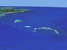
Aerial view of the group from the west. Needle Rocks is on the right and to the left of them is Maatsuyker Island. De Witt is the larger island on the left. Tasmania and the South East Cape are in the background. The view was computer generated from satellite data using NASA World Wind.
|
|
| Etymology | Joan Maetsuicker |
|---|---|
| Geography | |
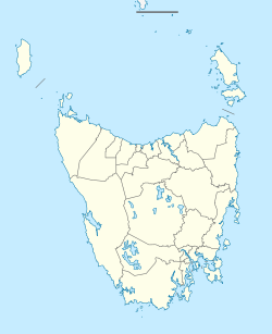
| Location | Southern Tasmania |
| Coordinates | 43°38′24″S 146°16′12″E / 43.64000°S 146.27000°E |
| Total islands | 8-12 (depending on sources) |
| Major islands |
|
| Administration | |
|
Australia
|
|
| State | Tasmania |
| Region | Southern |
| Demographics | |
| Population | Unpopulated |
The Maatsuyker Islands are a group of islands and small rocky islands. They are located about 5.5 kilometres (3.4 miles) off the southern coast of Tasmania, Australia. Maatsuyker Island is the most southerly island in this group. It is also the southernmost island on Australia's continental shelf. The continental shelf is the underwater land that extends from a continent.
Even further south than Maatsuyker, there are some exposed rocks. However, these rocks are not big enough to be called islands. Macquarie Island is another Australian territory far to the south. But it is a completely separate piece of land in the Southern Ocean.
This island group is famous for its amazing ocean wildlife. It also has very wet and windy weather. Plus, it is home to Australia's southernmost lighthouse. The Maatsuyker Islands are part of the Southwest National Park. This park is also a Tasmanian Wilderness World Heritage Site.
Contents
Exploring the Maatsuyker Islands
The Main Island Group
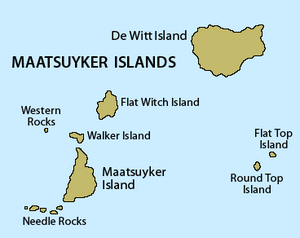
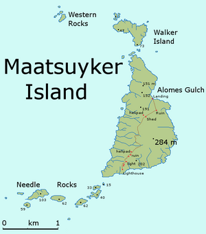
The Maatsuyker Islands group includes at least six islands and two sets of rocks. The main island, which gives the group its name, is Maatsuyker Island. It is about 2.6 kilometres (1.6 miles) long from north to south. It is also about 1.2 kilometres (0.75 miles) wide from east to west.
Just off the southwest tip of Maatsuyker Island are the Needle Rocks. These are also known as The Needles. To the north, you'll find Walker Island, Flat Witch Island, and the Western Rocks. De Witt Island is about 6.5 kilometres (4 miles) to the northeast. The other two islands, Flat Top Island and Round Top Island, are about 7 kilometres (4.3 miles) to the east. Maatsuyker Island itself is about 10.4 kilometres (6.5 miles) from the Tasmanian mainland.
Here is a list of the main islands and rocks in the group:
| Name | Location (Coordinates) | Other Names |
|---|---|---|
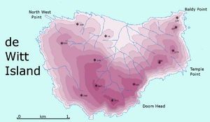
| De Witt Island | 43°35′51″S 146°21′35″E / 43.59750°S 146.35972°E | Big Witch |
| Flat Top Island | 43°38′24″S 146°23′03″E / 43.64000°S 146.38417°E | |
| Flat Witch Island | 43°37′08″S 146°17′35″E / 43.61889°S 146.29306°E | Little Witch |
| Maatsuyker Island | 43°39′18″S 146°16′23″E / 43.65500°S 146.27306°E | |
| Needle Rocks | 43°39′45″S 146°15′19″E / 43.66250°S 146.25528°E | The Needles |
| Round Top Island | 43°38′37″S 146°22′33″E / 43.64361°S 146.37583°E | |
| Walker Island | 43°37′57″S 146°16′33″E / 43.63250°S 146.27583°E | |
| Western Rocks | 43°37′46″S 146°15′29″E / 43.62944°S 146.25806°E | Black Rocks |
Some sources include a few more islands as part of the larger Maatsuyker group. For example, Nigel Brothers, a well-known expert on Tasmania's islands, adds four more.
| Chicken Island | 43°34′23″S 146°36′04″E / 43.57306°S 146.60111°E | |
| Hen Island | 43°34′12″S 146°34′59″E / 43.57000°S 146.58306°E | |
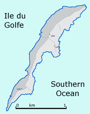
| Ile du Golfe | 43°34′15″S 146°31′30″E / 43.57083°S 146.52500°E | |
| Louisa Island | 43°32′13″S 146°20′42″E / 43.53694°S 146.34500°E |
These islands are what's left of the Tasmanian mainland after many years of erosion. This means they are usually steep and rocky.
Nearby Islands
There are other islands near the Maatsuyker group that are sometimes mentioned. These include the Breaksea Islands, Eddystone, Kathleen Island, Mewstone, Pedra Branca, Shanks Islands, and Trumpeter Islets. Some of these are quite far from Maatsuyker Island itself.
History of the Islands
How the Islands Got Their Name
Abel Tasman was the first European explorer known to reach Tasmania. He first saw Tasmania on November 24, 1642. His journal from December 1, 1642, mentions "Maetsuickers islands." This was just seven days after he first sighted Tasmania.
The islands were named after Joan Maetsuycker, who was a member of the Council of India. This council worked for the Dutch East India Company, which was Tasman's employer. Antonio Van Diemen, the Governor-General, had the largest island (Tasmania, then called Van Diemen's Land) named after him. So, the Maatsuyker Islands were named to honor Joan Maetsuycker.
There have been other ideas about where the name came from:
- Some thought it was named after a crew member, Mr. Maatsuyker. But the ship's logbook shows no one with that name was on board.
- Another idea was that "Maatsuyker" meant "mate seeker" in Dutch. This suggested that seal hunters looked for Aboriginal women there. However, "seeker" in Dutch is "zoeker," not "suicker." Still, we know Aboriginal people visited the island thousands of years before Europeans.
- Some believed the name meant "measure of sugar" in Dutch. They thought the island, covered in guano (bird droppings), looked like a spoonful of sugar. This idea is incorrect.
The Maatsuyker Island Lighthouse
In 1891, a lighthouse was finished on Maatsuyker Island. It is still Australia's most southerly lighthouse today. From when it first opened until an automatic light was installed, lighthouse keepers lived and worked there. They were the only people on the island.
The Maatsuyker Island Lighthouse was the last Australian lighthouse to be officially operated by lightkeepers. A second, smaller, automated lighthouse was put in place in 1996. It is not clear if volunteers will continue to work the lights on Maatsuyker Island.
Island Weather and Climate
The weather around the Maatsuyker Islands can be very harsh. The strong Roaring Forties winds are a big problem. The fastest wind gust ever recorded there was 176 kilometres per hour (109 miles per hour).
It is said that the first lighthouse keepers brought chickens to Maatsuyker. But the strong winds supposedly blew the chickens into the ocean! This could happen if they were left outside during storms. Even vegetables get blown flat by the wind. Surprisingly, they can still grow well, even though the garden faces the strong winds.
Besides the wind, it rains a lot. On average, there are 249 rainy days each year.
| Climate data for Maatsuyker Island Lighthouse (1981-2010) | |||||||||||||
|---|---|---|---|---|---|---|---|---|---|---|---|---|---|
| Month | Jan | Feb | Mar | Apr | May | Jun | Jul | Aug | Sep | Oct | Nov | Dec | Year |
| Record high °C (°F) | 31.6 (88.9) |
34.7 (94.5) |
32.4 (90.3) |
31.0 (87.8) |
22.0 (71.6) |
18.8 (65.8) |
17.5 (63.5) |
21.5 (70.7) |
24.6 (76.3) |
27.5 (81.5) |
30.3 (86.5) |
30.4 (86.7) |
34.7 (94.5) |
| Mean daily maximum °C (°F) | 16.9 (62.4) |
17.4 (63.3) |
16.2 (61.2) |
14.6 (58.3) |
13.0 (55.4) |
11.5 (52.7) |
11.1 (52.0) |
11.3 (52.3) |
12.0 (53.6) |
13.1 (55.6) |
14.4 (57.9) |
15.5 (59.9) |
13.9 (57.0) |
| Mean daily minimum °C (°F) | 10.9 (51.6) |
11.4 (52.5) |
10.7 (51.3) |
9.7 (49.5) |
8.7 (47.7) |
7.4 (45.3) |
6.9 (44.4) |
6.7 (44.1) |
6.9 (44.4) |
7.4 (45.3) |
8.6 (47.5) |
9.7 (49.5) |
8.8 (47.8) |
| Record low °C (°F) | 3.5 (38.3) |
5.2 (41.4) |
3.3 (37.9) |
0.2 (32.4) |
0.7 (33.3) |
1.5 (34.7) |
−1 (30) |
1.0 (33.8) |
0.8 (33.4) |
−1 (30) |
2.0 (35.6) |
3.2 (37.8) |
−1 (30) |
| Average precipitation mm (inches) | 83.5 (3.29) |
74.6 (2.94) |
82.0 (3.23) |
98.6 (3.88) |
109.7 (4.32) |
123.9 (4.88) |
137.4 (5.41) |
131.6 (5.18) |
118.2 (4.65) |
106.7 (4.20) |
86.7 (3.41) |
89.5 (3.52) |
1,242.7 (48.93) |
| Average precipitation days (≥ 1 mm) | 12.9 | 11.0 | 14.1 | 15.9 | 18.5 | 19.0 | 20.8 | 21.2 | 19.4 | 19.3 | 14.7 | 15.0 | 201.8 |
| Source: Bureau of Meteorology | |||||||||||||
Plants and Animals of Maatsuyker
Amazing Plant Life
Maatsuyker Island has a surprising variety of plants. The strong winds keep them from growing very tall. The soil is incredibly rich because of thousands of years of guano (sea bird droppings). This rich soil helps many native and introduced plants grow. For example, potatoes planted by old lighthouse keepers now grow wild!
Diverse Animal Life
Seals are very common around the islands. You can find both New Zealand fur seals and Australian fur seals. There are also southern elephant seals.
The Maatsuyker group is well known for its many birds. One special bird is the northern soft-plumaged petrel. This bird is critically endangered, meaning it's at very high risk of disappearing. Maatsuyker is the first place in Australia where these petrels were recorded breeding.
BirdLife International has named the Maatsuyker group an Important Bird Area (IBA). This is because it is home to over 1% of the world's population of short-tailed shearwaters (about 1.5 million pairs!). It also supports thousands of pairs of fairy prions, black-faced cormorants, little penguins, and common diving-petrels.
 | Victor J. Glover |
 | Yvonne Cagle |
 | Jeanette Epps |
 | Bernard A. Harris Jr. |


