MacDonald River (Côte-Nord) facts for kids
Quick facts for kids MacDonald River |
|
|---|---|

MacDonald River
|
|
| Native name | Rivière MacDonald |
| Country | Canada |
| Province | Quebec |
| Administrative region | Côte-Nord |
| Physical characteristics | |
| River mouth | 50°07′54″N 67°08′10″W / 50.131707°N 67.13602°W |
| Length | 42 kilometres (26 mi) |
| Basin features | |
| River system | Aux Rochers River |
| Tributaries |
|
| NRC id | EHCDZ |
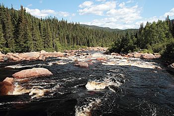
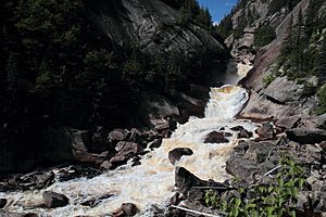
The MacDonald River (French: Rivière MacDonald) is a river in Quebec, Canada. It flows north of the lower Saint Lawrence River. This river is famous for its amazing waterfall, called the Chute MacDonald.
Contents
Where is the MacDonald River?
The MacDonald River is in a part of Quebec called Lac-Walker. This area is in the Sept-Rivières Regional County Municipality within the Côte-Nord region. The river is about 42 kilometres (26 mi) (about 26 miles) long.
It is one of the main rivers that flows into the Aux Rochers River. Other rivers that join the Aux Rochers include the Pasteur, Gravel, and Schmon.
The MacDonald River starts north of Lake Valilée. It gets its water from smaller streams and lakes like Lake des Deux Crétes and Lake Chemin de Fer. As it flows, the lower part of the river goes through the area planned for the Lake Walker National Park. This is where it meets the Ronald River. From there, it flows south, then east for about 5 kilometres (3.1 mi) (3 miles) to the north end of Lake Quatre Lieues. Finally, it continues east to join the Aux Rochers River south of Lake Walker.
The Cartier Railway runs along the MacDonald River valley for most of its length. This railway connects the Mont Wright iron mine near Fermont to Port-Cartier.
Nature and Environment
The area around the MacDonald River has a boreal climate. This means it has long, cold winters and short, cool summers. The region is part of the eastern spruce/moss forest, which is a type of boreal forest.
The average temperature here is about 0 °C (32 °F) (32°F) for the whole year. July is the warmest month, with an average of 16 °C (61 °F) (61°F). January is the coldest, with an average of −17 °C (1 °F) (1°F).
Why is it Called MacDonald River?
The Commission de toponymie du Québec is a group that names places in Quebec. They believe the MacDonald River and its smaller river, the Ronald River, were named after Ian and Ronald MacDonald.
Ian MacDonald was a manager at the Ontario Paper Company in Shelter Bay until 1935. Ronald was his son. The MacDonald River officially got its name on April 8, 1975.
River's Rocky History
The bottom of the MacDonald River valley is filled with layers of sand and dirt. These layers were left behind by melting glaciers a long time ago. In some parts of the lower river valley, you can see many ridges and old curves of the river. There are also crescent-shaped sandbars covered with alder trees.
The famous MacDonald River waterfall, Chute MacDonald, was formed because of a "glacial lock" or riegel. This is a spot where the rock was much harder and stronger, so the glaciers couldn't wear it down as easily. The waterfall drops about 30 metres (98 ft) (about 98 feet) down a slope. You can still see signs of the glaciers near the waterfall and further upstream, like smooth, polished rocks and scratches left by the ice.
Fun Things to Do at the River
The Chute MacDonald is a popular spot! You can get there from Baie-Comeau by driving east on Highway 138 to Port-Cartier. Then, you turn north onto Shelter Bay road. After about 33 kilometres (21 mi) (20 miles) on this dirt road, you'll find a parking spot near some rapids. From there, a clear and easy walking path leads you to the falls. At the waterfall, you'll find picnic tables, restrooms, and a bridge.
The MacDonald River and the Aux Rochers River are known for Atlantic salmon (Salmo salar). Fishing rules can change, but sometimes you can fish for other types of fish from May to September in certain areas. Salmon fishing is also allowed in specific sections during July to September.
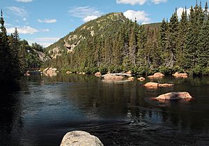
The river is great for canoeing, especially when the water is high. There aren't many places where you have to carry your canoe around obstacles. If you combine a trip on the MacDonald River with the Aux Rochers River, you can have a 52 kilometres (32 mi) (32 miles) long adventure!
The Port-Cartier-Sept-Îles Wildlife Sanctuary has created trails along the river. These trails lead from cabins to the Chute MacDonald. There's even a walkway and a gazebo at the falls, making it easier to see the natural beauty and the interesting rock formations. MacDonald Falls and its footbridge are big attractions in the Port-Cartier–Sept-Îles Wildlife Reserve.
The falls are also one of the main natural attractions that would be part of the proposed Lake Walker National Park. Other cool spots in this planned park include Lake Walker, Lake Quatre Lieux, the Forêt ancienne du Lac-Larry (an old forest), and the Aux Rochers River.
Lakes Connected to the River
Many lakes flow into the MacDonald River, mostly from the east. Here are some of them:
| Lake | Coordinates | Map |
|---|---|---|
| Lake Valilée | 50°32′00″N 67°24′45″W / 50.5333°N 67.4125°W | EIKAG |
| Lake Rouge | 50°31′50″N 67°21′40″W / 50.5305°N 67.3611°W | EHXQV |
| Lake Chisholm | 50°23′44″N 67°19′08″W / 50.3955°N 67.3188°W | EFXFS |
| Lake Cody | 50°18′37″N 67°20′26″W / 50.3102°N 67.3405°W | EJBIN |
| Lake Larry | 50°16′06″N 67°19′40″W / 50.2683°N 67.3277°W | EGXYT |
| Lake Jumbo | 50°15′20″N 67°19′50″W / 50.2555°N 67.3305°W | EGUPF |
| Lake Quatre Lieues | 50°03′24″N 67°09′00″W / 50.0566°N 67.1500°W | EHTVV |
Lake Jumbo: A Special Place
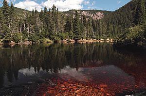
Lake Jumbo was officially named on October 3, 1972. It sits high up, about 427 meters (1,401 feet) above sea level. This lake is just south of Lake Larry and is in the southeast part of the proposed Lake Walker National Park. It's located between the Ronald River and the MacDonald River, and its water flows into the MacDonald River.
The area around Lake Jumbo has tall hills with flat tops and many streams. The eastern side of the lake is next to the Forêt ancienne du Lac-Larry (Lake Larry Old Growth Forest). This forest is special because it has very old black spruce and balsam fir trees, some over 200 years old! These trees haven't been badly affected by fires, insects, or logging.
Lake Quatre Lieues: Hunting and Fishing
Lake Quatre Lieues is in the very south of the proposed Lake Walker National Park. The MacDonald River flows through the northern part of this lake from west to east. The lake is about 116 metres (381 ft) (381 feet) above sea level.
The Port-Cartier–Sept-Îles Wildlife Reserve offers cabins for rent near Lake Quatre Lieues. People can go hunting and fishing in this area. The hunting area is quite large, about 150 square kilometres (58 sq mi) (58 square miles), and has hardwood forests that are about 50 years old, as well as older spruce trees.
 | William Lucy |
 | Charles Hayes |
 | Cleveland Robinson |


