Macauley Island facts for kids
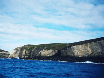
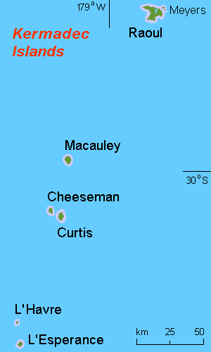
Macauley Island is a volcanic island. It is part of New Zealand's Kermadec Islands. The island is located in the southwest Pacific Ocean. It lies about halfway between New Zealand's North Island and Tonga. Its exact location is 30°14′S, 178°26′W.
Contents
Island Geography
Macauley Island is the second-largest of the Kermadec Islands. Only Raoul Island is bigger. Macauley Island covers an area of about 3.06 square kilometers (1.18 sq mi). This area includes nearby Haszard Island. Haszard Island is 220 meters (720 ft) to the east and about 5 hectares (12 acres) in size.
The island's shape is quite simple. It is a high, flat area with steep sides. The soft rock on the island often forms deep channels where water flows. The highest point on Macauley is Mount Haszard, which is 238 meters (781 ft) tall.
Volcanic Features
Macauley Island is part of a caldera. A caldera is a large, bowl-shaped hollow that forms after a volcano erupts and collapses. This caldera is centered about 8 kilometers (5 mi) to the north-west of the island. It sits on top of a large submarine volcano, which is a volcano under the sea.
The volcano last erupted around 4360 BC. This eruption was one of the biggest known in the last 10,000 years. It was rated as a VEI 7 eruption. This means it was very powerful.
Island History
People from Polynesia visited Macauley Island a long time ago. Scientists found a piece of obsidian rock there. Obsidian is a type of volcanic glass. This piece of obsidian came from Mayor Island / Tuhua in New Zealand. This shows that Polynesians traveled to Macauley Island.
The first European to visit Macauley Island was Lieutenant John Watts. He was a Royal Navy officer. He visited in late 1788 on a ship called the Lady Penrhyn. He named the island after George Mackenzie Macaulay, a London merchant.
Castaway Depot
In 1889, a castaway depot was set up on Macauley Island. A castaway depot was a place with supplies for shipwrecked sailors. These depots were regularly restocked until 1918.
Plants and Animals
Macauley Island is an important place for many seabirds to breed. Large numbers of black-winged petrels and white-necked petrels nest there. Other seabirds that breed on the island include grey noddies, sooty terns, and masked boobies. You can also find red-tailed tropicbirds, wedge-tailed shearwaters, and Kermadec little shearwaters. Kermadec petrels and Kermadec storm-petrels also make their homes there.
The island is also home to the Kermadec red-crowned parakeet. In the past, there were goats and kiore (Pacific rats) on the island. However, these animals have been removed.
Island Flora
The plants on the island are mostly sedges and ferns. Cyperus and Hypolepis are common types of plants found there.
Conservation Efforts
Long ago, the original forests on Macauley Island were burned. Goats were brought to the island. They were meant to be food for people who might get shipwrecked.
The New Zealand Wildlife Service removed the goats in the late 1960s and early 1970s. To protect the island's wildlife, Macauley is now a nature reserve. It is managed by the New Zealand Department of Conservation (DOC). In 2006, DOC used special aerial drops of poison bait. This helped to remove introduced rats from the island.
See also
 In Spanish: Isla Macauley para niños
 | Janet Taylor Pickett |
 | Synthia Saint James |
 | Howardena Pindell |
 | Faith Ringgold |


