Machiasport, Maine facts for kids
Quick facts for kids
Machiasport, Maine
|
|
|---|---|

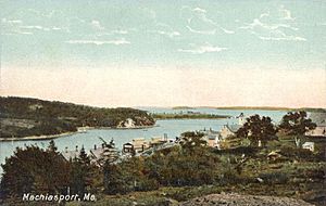
Machiasport c. 1908
|
|
| Country | United States |
| State | Maine |
| County | Washington |
| Incorporated | 1826 |
| Area | |
| • Total | 61.61 sq mi (159.57 km2) |
| • Land | 21.41 sq mi (55.45 km2) |
| • Water | 40.20 sq mi (104.12 km2) |
| Elevation | 0 ft (0 m) |
| Population
(2020)
|
|
| • Total | 962 |
| • Density | 45/sq mi (17.3/km2) |
| Time zone | UTC-5 (Eastern (EST)) |
| • Summer (DST) | UTC-4 (EDT) |
| ZIP code |
04655
|
| Area code(s) | 207 |
| FIPS code | 23-42100 |
| GNIS feature ID | 0582574 |
Machiasport is a small town located in Washington County, Maine, in the United States. In 2020, about 962 people lived there. Machiasport is known as a historic seaport and a fun place for tourists to visit.
Contents
History of Machiasport
Early Trading Post and French Conflict
In 1633, a company from Plymouth set up a trading post here. They wanted to trade with the Native Americans. However, this area was part of Acadia, which New France claimed as its own. So, in 1634, French forces from Port Royal attacked and took over the trading post. This was led by Charles de Saint-Étienne de la Tour.
Becoming a Town
In 1770, the land was given to 80 people by the Massachusetts government. Many of them were from Scarborough. At first, this area was part of Machias, which became a town in 1784. Later, in 1826, Machiasport became its own separate town.
Battles and Forts
In 1775, local people led by Jeremiah O'Brien captured a British ship called HMS Margaretta. After this, the residents built a small wall, called a breastworks, to protect the Machias River and nearby settlements. Later that year, the British sent four ships. They defeated the local militia, destroyed the breastworks, and burned some buildings.
In 1777, the fort was rebuilt. It was shaped like a crescent and had four cannons. In 1781, it became part of the national defense and was named Fort O'Brien. From 1808 to 1809, a blockhouse (a small fort), barracks (soldiers' living quarters), and another battery were built. During the War of 1812, in September 1814, the British captured Fort O'Brien and burned the barracks.
Civil War Fort and Historic Site
In 1863, during the American Civil War, a new fort called Fort Machias was built next to the old Fort O'Brien ruins. This fort was made of earth and had five cannons. Soldiers were stationed there from 1863 to 1865.
In 1923, the U.S. government gave both fort sites to the state of Maine. Today, the Maine Bureau of Parks and Lands manages them as a historic site. In 1969, both forts were added to the National Register of Historic Places.
An anthropologist and filmmaker named Anna Grimshaw has made several documentary films about the people living in Machiasport.
Geography of Machiasport
Machiasport covers an area of about 61.61 square miles (159.57 square kilometers). About 21.41 square miles (55.45 square kilometers) is land, and 40.20 square miles (104.12 square kilometers) is water. The Machias River flows through the town. Machiasport is located at the top of Machias Bay, which is part of the Gulf of Maine in the Atlantic Ocean.
The town has two main roads, Route 92 and Route 191. It shares borders with East Machias to the north, Whiting to the northeast, and Machias to the west. Across the water, it is near Cutler to the east and Roque Bluffs to the southwest.
Population Information
| Historical population | |||
|---|---|---|---|
| Census | Pop. | %± | |
| 1830 | 688 | — | |
| 1840 | 834 | 21.2% | |
| 1850 | 1,266 | 51.8% | |
| 1860 | 1,502 | 18.6% | |
| 1870 | 1,526 | 1.6% | |
| 1880 | 1,531 | 0.3% | |
| 1890 | 1,437 | −6.1% | |
| 1900 | 1,218 | −15.2% | |
| 1910 | 1,218 | 0.0% | |
| 1920 | 1,117 | −8.3% | |
| 1930 | 851 | −23.8% | |
| 1940 | 818 | −3.9% | |
| 1950 | 781 | −4.5% | |
| 1960 | 980 | 25.5% | |
| 1970 | 887 | −9.5% | |
| 1980 | 1,108 | 24.9% | |
| 1990 | 1,166 | 5.2% | |
| 2000 | 1,160 | −0.5% | |
| 2010 | 1,119 | −3.5% | |
| 2020 | 962 | −14.0% | |
| U.S. Decennial Census | |||
Machiasport's People in 2010
In 2010, there were 1,119 people living in Machiasport. These people lived in 410 households, and 277 of these were families. Most of the people living in Machiasport were White.
The average age of people in the town was about 43 years old. About 18% of the residents were under 18 years old, and about 18% were 65 years or older.
Places to Visit in Machiasport
- Fort O'Brien State Historic Site
- Larrabee Heath]
- Liberty Lighthouse[1]—This lighthouse was designed by Alexander Parris.
- Liberty Hall (built in 1873)
- Machiasport Historical Society & Museum]
- Jasper Beach
Notable People from Machiasport
- Francis Gano Benedict, a nutritionist
- William Coperthwaite, a naturalist
- David Freedberg, a professor
See also
 In Spanish: Machiasport (Maine) para niños
 | Kyle Baker |
 | Joseph Yoakum |
 | Laura Wheeler Waring |
 | Henry Ossawa Tanner |


