Madisonville, Louisiana facts for kids
Quick facts for kids
Madisonville, Louisiana
|
|
|---|---|
|
Town
|
|
| Town of Madisonville | |
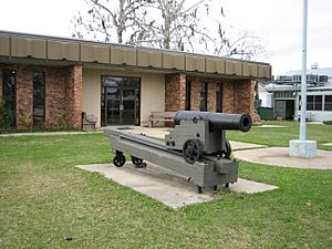
Madisonville Town Hall
|
|
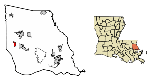
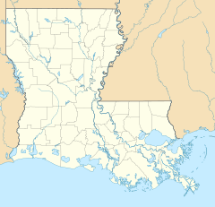
Location of Madisonville in St. Tammany Parish, Louisiana.
|
|
| Country | United States |
| State | Louisiana |
| Parish | St. Tammany |
| Founded | 1800 |
| Named for | James Madison |
| Area | |
| • Total | 2.55 sq mi (6.60 km2) |
| • Land | 2.53 sq mi (6.54 km2) |
| • Water | 0.02 sq mi (0.06 km2) |
| Elevation | 7 ft (2 m) |
| Population
(2020)
|
|
| • Total | 850 |
| • Density | 336.37/sq mi (129.88/km2) |
| Time zone | UTC-6 (CST) |
| • Summer (DST) | UTC-5 (CDT) |
| Area code(s) | 985 |
| FIPS code | 22-47560 |
| Website | http://www.townofmadisonville.org |
Madisonville is a small town located in St. Tammany Parish, in the state of Louisiana in the United States. In 2020, about 850 people lived there. It is part of the larger New Orleans area. The town's ZIP code is 70447.
Contents
History of Madisonville
Madisonville was started in 1800 by Jean Baptiste Baham. It was first called "Coquille" or "Cokie" because there were many shells in the area. This was even before the United States owned this land. The town was built on the site of an old Native American village called "Chiconcte." Around 1811, the town was renamed to honor US President James Madison.
Early Port Town and Civil War Impact
Before the Civil War, Madisonville was an important port. It sent bricks and other goods from towns along the Tchefuncte River to New Orleans. When the Union Army took control of New Orleans during the Civil War, trade with Madisonville stopped. This was very bad for the local economy, and it took many years for the town to recover.
Modern Growth and Challenges
In the second half of the 1900s, the Lake Pontchartrain Causeway and new roads helped Madisonville connect more with the Greater New Orleans region.
However, Madisonville has faced challenges from hurricanes. In 2005, much of the town flooded when Hurricane Katrina caused a storm surge from Lake Pontchartrain. The police and fire stations, along with the town hall, were damaged. The town flooded again in 2012 during Hurricane Isaac. After these floods, town buildings were repaired. The police station moved to a historic building, and the fire station moved to a new location.
The Jahncke Shipyard Story
Frederick (Fritz) Jahncke came to New Orleans from Germany in 1870. He started a business that built the first sidewalks in New Orleans. His company also began to get sand and shells from the Tchefuncte River to make concrete for New Orleans.
Jahncke later bought part of the Baham Shipyard and started building ships. In 1905, he bought the rest of the shipyard, including land, warehouses, and docks. After he passed away in 1911, his sons took over the company. During World War I in 1917, the company began building five wooden ships for the US Navy. Two ships, the SS Bayou Teche and the SS Balabac, were finished in 1918. The war ended before the other three ships were completed. The SS Abbeville and the SS Pontchartrain were finished in 1919. The last ship was burned across the river, and parts of its hull can still be seen at low tide.
Today, the Jahncke Shipyard is a historical site. Its shipbuilding history lives on in the area's maritime industry. Just two miles downriver, Marina del Ray has become the biggest marina in the region. It is a key place for local boaters and visitors.
Geography and Location
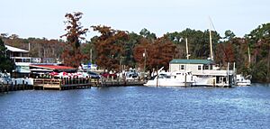
The town of Madisonville is located on the banks of the Tchefuncte River. This is close to where the river flows into Lake Pontchartrain. The town covers about 2.51 square miles (6.51 square kilometers) of land. Only a small part, about 0.02 square miles (0.06 square kilometers), is water.
The Tchefuncte River is a main feature of the area. It offers beautiful views and chances for boating and fun activities. You can easily get to the river through local marinas and docks. Marina del Ray is the largest and easiest to access. It is a popular spot for boaters and visitors who want to explore the waterway.
Population Information
| Historical population | |||
|---|---|---|---|
| Census | Pop. | %± | |
| 1870 | 398 | — | |
| 1880 | 441 | 10.8% | |
| 1890 | 574 | 30.2% | |
| 1900 | 779 | 35.7% | |
| 1910 | 1,028 | 32.0% | |
| 1920 | 1,103 | 7.3% | |
| 1930 | 837 | −24.1% | |
| 1940 | 915 | 9.3% | |
| 1950 | 861 | −5.9% | |
| 1960 | 860 | −0.1% | |
| 1970 | 801 | −6.9% | |
| 1980 | 799 | −0.2% | |
| 1990 | 659 | −17.5% | |
| 2000 | 677 | 2.7% | |
| 2010 | 748 | 10.5% | |
| 2020 | 850 | 13.6% | |
| U.S. Decennial Census | |||
| Race | Number | Percentage |
|---|---|---|
| White (non-Hispanic) | 741 | 87.18% |
| Black or African American (non-Hispanic) | 38 | 4.47% |
| Native American | 4 | 0.47% |
| Asian | 12 | 1.41% |
| Other/Mixed | 21 | 2.47% |
| Hispanic or Latino | 34 | 4.0% |
In 2020, there were 850 people living in Madisonville. There were 333 households and 201 families. In 2000, there were 677 people, 302 households, and 186 families. The town had about 277 people per square mile (107 people per square kilometer). There were 346 housing units, which are homes or apartments.
Most people in Madisonville are White (87.18% in 2020). Other groups include Black or African American (4.47%), Native American (0.47%), and Asian (1.41%). About 4.0% of the population was Hispanic or Latino.
In 2000, about 21.9% of households had children under 18 living with them. About 44.7% were married couples. Around 10.6% had a female head of household with no husband. About 38.4% were not families. Many households (31.8%) were made up of single individuals. About 8.9% of households had someone aged 65 or older living alone. The average household had 2.24 people. The average family had 2.81 people.
The population was spread out by age. About 19.2% were under 18. About 28.8% were between 25 and 44. The median age was 42 years old. This means half the people were younger than 42 and half were older.
Arts and Culture
Pontchartrain Basin Maritime Museum
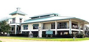
Madisonville is home to the Lake Pontchartrain Basin Maritime Museum. This museum hosts the Wooden Boat Festival every fall. It's a fun event where you can see many different kinds of wooden boats.
Tchefuncte River Lighthouse
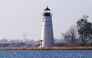
The Tchefuncte River Lighthouse is owned by the Town of Madisonville. The Lake Pontchartrain Basin Maritime Museum helps manage it. The lighthouse was added to the National Register of Historic Places in 1986. You can only reach it by boat.
The lighthouse can be seen from Marina del Ray and the Madisonville Boat Launch. It survived Hurricanes Katrina and Rita and is still an important historical site. The house where the lighthouse keepers used to live was moved to the museum grounds.
Education
The St. Tammany Parish Public School System manages all public schools in the parish. Here are the schools that serve students from Madisonville:
- Madisonville Elementary School (for pre-kindergarten to 2nd grade)
- Lancaster Elementary School (for grades 3 to 6)
- Madisonville Junior High School (for grades 7 and 8)
- Mandeville High School (for grades 9 to 12) in Mandeville
The St. Tammany Parish Library also has a branch in Madisonville. For older students, there are two community colleges nearby: Northshore Technical Community College and Delgado Community College.
Notable People
Here are some well-known people who are from or have lived in Madisonville:
- Cag Cagnolatti, a musician
- Leah Chase, a famous chef
- John Neely Kennedy, a United States Senator from Louisiana
- Irv Stein, a baseball player
See also
 In Spanish: Madisonville (Luisiana) para niños


