
Magnolia, Ohio facts for kids
Quick facts for kids
Magnolia, Ohio
|
|
|---|---|
|
Village
|
|
.JPG)
The Magnolia Flouring Mill was established by the village's founder.
|
|

Location of Magnolia, Ohio
|
|

Location of Magnolia in Stark County
|
|
| Country | United States |
| State | Ohio |
| Counties | Stark, Carroll |
| Area | |
| • Total | 0.80 sq mi (2.07 km2) |
| • Land | 0.80 sq mi (2.07 km2) |
| • Water | 0 sq mi (0.00 km2) |
| Elevation | 988 ft (301 m) |
| Population
(2020)
|
|
| • Total | 1,013 |
| • Density | 1,267.83/sq mi (489.61/km2) |
| Time zone | UTC-5 (Eastern (EST)) |
| • Summer (DST) | UTC-4 (EDT) |
| ZIP code |
44643
|
| Area code(s) | 330 |
| FIPS code | 39-46844 |
| GNIS feature ID | 2399224 |
Magnolia is a small village located in the state of Ohio, USA. It is found in both Carroll and Stark counties. In 2020, about 1,013 people lived there. Magnolia is part of the larger Canton–Massillon metropolitan area.
Contents
History of Magnolia
The village of Magnolia has an interesting past. It was first planned out in 1834 by Richard Elson and John W. Smith. A few years later, in 1836, another village called Downingville was started nearby by Isaac Miller. Downingville was named after the Downes family, who were early settlers from Ireland and England.
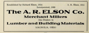
These two villages eventually joined together. On February 1, 1846, they officially became one village named Magnolia. The village got its name from a local gristmill called Magnolia Mills. A gristmill is a place where grain is ground into flour.
To keep the town safe from floods, the Muskingum Watershed Conservancy District built the Magnolia Levee. A levee is a wall or an embankment built to prevent a river from overflowing.
Where is Magnolia?
Magnolia is located right next to Sandy Creek. This village covers an area of about 0.87 square miles (2.07 square kilometers), and all of it is land.
You can find Magnolia where two state roads meet: State Route 183 and State Route 542.
People of Magnolia
| Historical population | |||
|---|---|---|---|
| Census | Pop. | %± | |
| 1880 | 121 | — | |
| 1900 | 431 | — | |
| 1910 | 556 | 29.0% | |
| 1920 | 605 | 8.8% | |
| 1930 | 685 | 13.2% | |
| 1940 | 819 | 19.6% | |
| 1950 | 901 | 10.0% | |
| 1960 | 935 | 3.8% | |
| 1970 | 1,064 | 13.8% | |
| 1980 | 986 | −7.3% | |
| 1990 | 937 | −5.0% | |
| 2000 | 931 | −0.6% | |
| 2010 | 978 | 5.0% | |
| 2020 | 1,013 | 3.6% | |

Population in 2010
In 2010, there were 978 people living in Magnolia. These people lived in 384 households, and 266 of those were families. The village had about 1,124 people per square mile.
Most of the people in Magnolia were White (97.8%). A small number were African American, Native American, or Asian. About 1.2% of the population identified as Hispanic or Latino.
About 34% of the households had children under 18 living with them. Many households (55.5%) were married couples. The average age of people in Magnolia was 38.9 years old.
Education in Magnolia
Students who live in Magnolia attend schools in the Sandy Valley Local School District.
Famous People from Magnolia
Many notable people have come from Magnolia, Ohio. Here are a few:
- Iorwith Wilbur Abel – He was a very important leader who helped start the United Steelworkers of America. He also served as a vice-president of the AFL–CIO, a large group of labor unions.
- Jeff Boals – He is currently the Head Coach for the basketball team at Ohio University.
- Vince Costello – He was a professional American football player who played as a linebacker.
- John Dagenhard – He was a Major League Baseball pitcher.
- Joe R. Hastings – He was a brave United States Army soldier who received the Medal of Honor for his actions during World War II.
- John J. Whitacre – He served as a US Congressman.
Images for kids
-
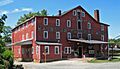
The Magnolia Flouring Mill was established by the village's founder.
-
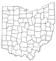
Location of Magnolia, Ohio
-
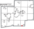
Location of Magnolia in Stark County
See also
 In Spanish: Magnolia (Ohio) para niños
