
Main Street Historic District (Danbury, Connecticut) facts for kids
Quick facts for kids |
|
|
Main Street Historic District
|
|

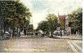
Main Street in 2007
|
|

Location in Connecticut

Location in the United States
|
|
| Location | Danbury, CT |
|---|---|
| Area | 47 acres (19 ha). |
| Built | 1785–1931 |
| Architect | multiple |
| Architectural style | multiple, primarily Italianate and Romanesque |
| NRHP reference No. | 83003508 |
| Added to NRHP | November 29, 1983 |
The Main Street Historic District in Danbury, Connecticut, is a very special place. It's the oldest part of the city and has always been its main center for shops and businesses. Imagine a place where 132 buildings tell stories from the late 1700s all the way to the early 1900s! Many of these buildings are considered "contributing properties," meaning they help show the area's history.
What makes this district unique? Unlike many old industrial towns, Danbury's Main Street didn't grow because of a port or a river providing water power. It grew for other reasons!
This street was first called Town Street when Danbury was settled in the late 1600s. It was so important that local farmers just called it "Danbury Street." The Revolutionary War even started here, with the first shot fired at the British. As Danbury grew, especially with the arrival of railroads, its hat-making industry became super famous.
But things changed. After World War II, hats weren't as popular, and hat factories closed. Floods in 1955 also caused damage. Many businesses moved to a new shopping mall. Luckily, Main Street wasn't torn down like some other old city areas. In 1983, it was officially recognized as a historic district and added to the National Register of Historic Places. This means it's protected because of its important history.
Today, downtown Danbury is busy again! Businesses worked together to improve the area. The city also built fun places like a railroad museum and an ice arena. Many new people have moved to Danbury, including immigrants from Latin America, who have opened new businesses on Main Street.
Contents
Exploring Main Street's Location
The Main Street Historic District stretches for about three-quarters of a mile. It runs along Main Street (which is also Route 53) from the John Rider House at the south end to White Street at the north. You can tell where the district ends because the buildings change to more modern ones, or you see flood control areas near the Still River.
The district also includes parts of nine smaller streets nearby, like Elm, Keeler, West, and White streets. Even the old Wooster Street Cemetery is part of it! The very center of Danbury is close to 238 Main Street. The land here looks flat, but it actually slopes a little towards the Still River.
North of the district, Main Street continues with more shops until you reach Interstate 84. South of the district, you'll find a mix of homes and businesses. To the east, downtown continues towards the train station. West of Main Street, you'll find mostly homes.
This area is a busy city center with lots of commercial buildings. Most of them are two stories tall and face Main Street. Some buildings have shops on the first floor and apartments upstairs. You'll also see government buildings, like the post office and courthouse, and churches. St. Peter's Church, for example, has a tall spire that stands out in the city's skyline. Homes are usually found on the side streets. There are also open spaces, like Elmwood Park, which is a nice green area in the middle of Main Street.
The district covers about 47 acres and has 132 properties. Out of these, 97 are "contributing properties," meaning they add to the district's historical feel. One special building, the John Rider House, is so important that it's listed on the National Register of Historic Places all by itself! The buildings show many different styles, from older Georgian homes to newer Colonial Revival and Modernist designs. This shows how the business district grew over time.
A Look Back: Main Street's Journey Through Time
For a long time, Danbury and Main Street were almost the same thing! When railroads arrived in the mid-1800s, and hat-making became a huge industry, the city started to grow beyond just Main Street. By the late 1800s, what was once a small village had become a city, with Main Street as its busy heart.
Later, cars changed things. Traffic moved away from Main Street, and shops started opening in other areas. But Danbury has worked hard to bring Main Street back to life. New immigrants have also helped make the area lively again.
How Danbury Began (1684–1800)
Danbury started right here on Main Street. The first eight families who moved from Norwalk in 1684 to create a farming community called it Town Street. Their success led to other towns like New Milford and Ridgefield being founded nearby. Danbury's location, where major north-south and east-west routes met, helped it grow. The first church, a Congregationalist one, was the center of early community life.
During the Revolutionary War in 1777, British soldiers raided Danbury and destroyed most of its buildings. Danbury was important during the war because it was a supply center for the Continental Army. Soldiers' hospitals were here, and local workers made things like nails, wagons, and shoes for the army.
After America became independent in 1784, Danbury became a "half-shire town," meaning it shared the duties of a county seat (like a county capital) with Fairfield. The main church moved north in 1785, causing new buildings to pop up there. In 1792, the first courthouse and jail were built where modern ones stand today.
Growing with Industry (1801–1851)
After the war, new industries started that made Danbury rich for over a century. Hat-making was already happening before the Revolution, but afterward, Danbury became the country's leader in hats! By 1800, hat makers were producing 20,000 hats a year. They sold hats all over the Southern states. Other local businesses made boots, shoes, and combs. Some buildings from this time are still here, like the 1790 John Dodd shop, which is the oldest commercial building in the city.
In 1801, the land that is now Elmwood Park was given to the town to be a public common. It was used for military training and early fairs. Even though side streets existed, Danbury was still mostly "one street" with homes, shops, hat factories, and churches. Farmers called it "Danbury Street."
In 1822, Main Street and the area around it became a "borough." This meant it could have its own fire companies and water system. Growth continued, and banks opened. In 1829, land from the Congregational church was sold and divided, leading to large double houses being built. The Fry & Gregory saddle factory, built in 1836, is another example of a business from this time.
The first local bank, Savings Bank of Danbury, started in the home of George Ives, the grandfather of famous composer Charles Ives. Downtown really started to look like it does today in 1852 when the Danbury and Norwalk Railroad arrived. Landowners in northern Main Street, who owned shares in the railroad, had the train station built there. This made their land and businesses more valuable.
The Hat City's Golden Age (1851–1945)
The railroads brought big changes. In the 1850s, the first multi-story brick commercial buildings went up. Large steam-powered hat factories were built, bringing many new workers to Danbury. People moved here from nearby towns and from other countries like England, Ireland, and Germany. Danbury's population almost doubled between 1850 and 1860!
Main Street became even more focused on businesses. Hat makers were skilled workers who could afford their own homes, often on the side streets to the west. Hat factories were mostly in the north, near the river. Wooster Square, where Main, Elm, and White streets meet, became a key area because of the train station.
After the Civil War, more banks and public buildings were built. In 1873, a new jail was constructed. In 1878, a beautiful library was given to the city by Alexander White, a leader in the hat industry. The Danbury News building also went up, home to famous humor writer James Montgomery Bailey. A monument to local soldiers who died in the Civil War was built in 1880. New firehouses and a City Hall were also built.
The intersection of Main and West streets, now called City Hall Square, became the new center of the district. Businesses built impressive new buildings, some reaching three or four stories. In 1887, the Union Savings Bank moved into its current building.
By the end of the 1800s, Danbury became a city. Main Street was paved with granite blocks, and new sidewalks, sewers, electric lights, and a horse-drawn trolley system were installed.
In the late 1890s, Danbury had 35 hat factories, leading the nation in production and employing 5,000 people! A neon sign with a derby hat and the words "Danbury Crowns Them All" welcomed visitors at the new train station. Downtown also became an important place for education, with Danbury High School located in the Union Savings Bank building.
As the 1900s began, the city was at its busiest. New U.S. highways 6, 7, and 202 passed through downtown, bringing car traffic. Main Street became a popular shopping spot, with stores like Woolworth's and Sears opening, drawing customers from nearby towns. Car dealerships also opened on Main Street.
Challenges and Changes (1946–1995)
After World War II, Danbury's luck changed. People started wearing hats less, so hat factories had to cut back or close. In 1955, floods from hurricanes badly damaged many businesses, especially near Wooster Square. This led to some of the first efforts to save historic buildings. For example, the Dodd Shop was moved to a new location in 1958 to save it from being torn down.
In 1959, the city and town of Danbury merged. Businesses affected by the flood started moving to newer, larger spaces outside the city center. The empty, damaged areas downtown were part of "urban renewal" programs in the late 1960s and early 1970s. Whole blocks were torn down, partly to make way for flood control projects along the Still River.
In the 1970s, the completion of Interstate 84 caused another problem for Main Street. All the U.S. highways were rerouted onto the expressway, away from downtown. This made businesses outside the city center even more popular. Remaining business owners started fixing up their properties, and efforts to preserve historic buildings grew.
The Danbury Preservation Trust, formed in the 1950s, received a grant in 1979 to study and list historic buildings on Main Street. They looked at 300 buildings before deciding on the area that became the historic district. It was officially added to the National Register of Historic Places in 1983. The city now has special rules to protect its historic character.
The 1980s brought a big challenge. In 1981, the last Danbury Fair was held. The fairground was bought and turned into a shopping mall, which opened in 1986. Its location near the highway made it very popular. Main Street's merchants formed a special group called CityCenter Danbury to help downtown. Even though Main Street wouldn't be the main shopping spot anymore, both the mall and downtown did well for a while. But when the economy slowed down in the early 1990s, people worried. The closure of Steinbach's, the last department store on Main Street in 1991, seemed to confirm these fears.
To help, the city built a parking garage and planned a complex with a movie theater, shops, and homes to attract more people. They also hired a consultant to help group similar shops together downtown.
Main Street's Comeback (1996–Present)
By the mid-1990s, these efforts started to work. Danbury changed from an industrial town to a place where people lived and commuted to New York City. Big companies built facilities here, and new homes went up. In 1996, most of Danbury's industrial and office spaces were full. Ives Street was transformed into a fun Dining and Entertainment District, with old buildings becoming restaurants and nightclubs. People felt that "the downtown is coming back strong."
The community also came together after a fire badly damaged the library in 1996. Voters approved money to improve City Hall and rebuild the library. The Danbury Ice Arena, home to ice hockey teams, was also built near Main Street in 1999, offering another fun place to visit along with the Danbury Railway Museum (in the old train station).
Just like in the mid-1800s, immigrants helped bring downtown back to life in the early 2000s. This time, they were mainly from Latin America, especially Ecuador and Brazil. They worked in construction and opened new businesses on Main Street.
Notable Buildings and Places
Some buildings in the district are very special because of their history or architecture. The John Rider House was even listed on the National Register before the whole district was created!
- American Legion Hall, 32–52 Elm Street. This 1927 building shows the style of local architect Philip Sunderland.
- Benedict & Nichols Building, 191-193 Main Street. Built in 1852, this was Danbury's first three-story commercial building.
- Chiarella Block, 272 Main Street. This building from 1914–15 is one of the first in the district to show the Colonial Revival style.
- Commercial Building at 131 Main Street. Built in 1931, this is the newest contributing property. It has a modern design with some Art Deco elements.
- Commercial Building at 141 Main Street. This 1907 building has a dedication plaque written in both English and Arabic.
- Commercial Building at 279–283 Main Street. First built in 1853, parts of its front were later redone in Tudor and modernist styles.
- Crofut Block, 253–255 Main Street. This 1876 brick building is a great example of the Italianate style, with fancy window hoods and a pressed tin ceiling inside.
- Danbury News Building, 288 Main Street. This 1873 building had a unique Queen Anne style tower added in 1893.
- Old Danbury Library, 254 Main Street. Given to the city in 1878, its brick front with colorful sandstone and a slate roof makes it the only High Victorian Gothic building in the area.
- John Dodd Shop, 43 Main Street, rear. This small wooden building from 1790 is the oldest commercial building in the district. It was moved to save it!
- Elmwood Park, in the center of Main Street. This park was originally given to the town as a common area. It was once home to the first church in Danbury.
- Fairfield County Courthouse, 71 Main Street. A beautiful 1899 Beaux Arts building that now serves as a juvenile court.
- Hornig Block, 10–16 Elm Street. This 1882 Italianate building is the only one in the district with pressed-metal siding.
- Houses at 101–103 and 105–107 Main Street. These two double houses show Danbury's early growth in the 1830s.
- Humane Hose Co. No. 1 Firehouse, 6 Boughton Street. This 1911 Italianate firehouse is still used by the police today.
- Old Fairfield County Jail, 80 Main Street. This 1872 building was used as a jail until 1969. Today, it's mostly senior housing, with a small museum on the ground floor.
- Old Fire Station, 5-7 Ives Street. Built in 1883, this was one of Danbury's first big public buildings. It's now apartments.
- Old Post Office, 258 Main Street. This 1876 Italianate brick building has cool window hoods.
- Old Saddle Factory, 68 Main Street. An 1836 wooden building that was later used as housing and is now office space.
- Old Southern New England Telephone Company Building, 31 West Street. This 1908 brick building has Dutch Colonial Revival touches, like its unique stepped roof.
- John Rider House, 43 Main Street. This wooden house from 1785 is the oldest property in the district. It's now home to the Danbury Historical Society and Museum.
- Seifert Armory, 5–15 Library Place. This five-story 1891 brick building has been turned into apartments.
- St. James Episcopal Church, 25 West Street. A granite Gothic Revival church completed in 1872, making it the oldest church building in the district.
- St. Peter's Catholic Church, 119 Main Street. The 175-foot spire of this 1870s building is a landmark in Danbury. It was the first Catholic church in northern Fairfield County.
- St. Peter's Convent, 88 Main Street. An 1895 Renaissance Revival brick building with a copper roof.
- St. Peter's Rectory, 104 Main Street. A three-story 1891 Richardsonian Romanesque brick building with two round towers.
- St. Peter's School, 98 Main Street. An 1895 Italianate brick building with a bell tower.
- Sears Building, 129 Main Street. Built by Sears in 1929, it was one of the first modern buildings in the district.
- Thomas Settle Building, 248 Main Street. This 1887 commercial building was designed by Warren Briggs. Its original roof was removed after a 1973 fire.
- Soldiers' Monument, Main and West streets. This granite statue of a Union Army soldier on a 12-foot column was built in 1878 to remember local soldiers who died in the Civil War.
- Union Savings Bank, 226–228 Main Street. A unique brick building from 1887 that was considered one of the city's most special.
- U.S. Post Office, 265 Main Street. This two-story brick Georgian Revival building has a beautiful interior.
- Wooster Cemetery, Wooster Street behind the old jail building. Danbury's oldest cemetery, with some graves from around 1700.
- Wooster Square This part of the city is named after General David Wooster, who died defending Danbury in 1777. It became important in the 1880s because it was close to the growing railroads and hat factories. Sadly, a flood in 1955 caused a lot of damage here. An electric trolley used to run between Wooster Square and Bethel from 1887 to 1926.
Images for kids
-
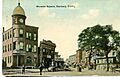
Danbury News Building in Wooster Square, from a 1915 postcard
-
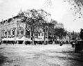
Wooster Square in patriotic decorations (1890s)
-
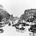
Looking south to Main Street, Danbury (1910)
-
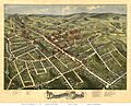
1875 picture map of Danbury
-
1907 postcard of Main Street from White Street
-
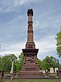
Monument to David Wooster in Wooster Cemetery


