Manchester (CDP), Connecticut facts for kids
Quick facts for kids
Manchester, Connecticut
|
|
|---|---|

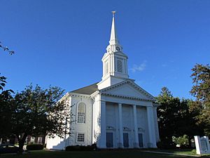
Center Congregational Church
|
|
| State | Connecticut |
| County | Hartford |
| Town | Manchester |
| Area | |
| • Total | 6.50 sq mi (16.83 km2) |
| • Land | 6.46 sq mi (16.74 km2) |
| • Water | 0.03 sq mi (0.09 km2) |
| Elevation | 272 ft (83 m) |
| Population
(2010)
|
|
| • Total | 30,577 |
| • Density | 4,731/sq mi (1,826.7/km2) |
| ZIP codes |
06040, 06042
|
| FIPS code | 09-44690 |
| GNIS feature ID | 2378342 |
Manchester is a special area in Hartford County, Connecticut. It is known as a census-designated place (CDP). This means it's like the main, busy part of the larger town of Manchester.
In 2010, about 30,577 people lived in the Manchester CDP. This was out of 58,241 people in the entire town of Manchester.
Contents
Exploring Manchester's Location
The Manchester CDP is located right in the middle of the larger town of Manchester. It stretches east all the way to the border of Bolton.
Manchester's Boundaries
The northern edge of this area mainly follows streets like Lydall Street and Woodland Street. To the west, it goes as far as New State Road. The southern border follows Hartford Road and Charter Oak Street. The eastern part of the CDP is next to U.S. Routes 6 and 44.
Major Roads and Highways
Two important roads, U.S. Routes 6 and 44, run together through the center of Manchester. They are known as Center Street. These roads can take you about 8 miles (13 km) west to Hartford, which is the state capital.
If you go east, US 6 leads to Willimantic, and US 44 goes to Storrs. Another big highway, Interstate 384, passes just south of the Manchester CDP. You can get on it from Exits 1 through 5. Connecticut Route 83 also goes through the center of Manchester as Main Street. It leads north to Interstate 84 and south to Connecticut Route 2 in East Glastonbury.
Land and Water Features
The Manchester CDP covers about 6.5 square miles (16.8 square kilometers) of land. A very small part, about 0.03 square miles (0.09 square kilometers), is water. All the water in the CDP flows west into the Hockanum River. This river then flows into the Connecticut River.
Understanding Manchester's Population
Demographics is a word that means studying the people who live in a place. This includes things like how many people there are, their ages, and their backgrounds.
Population Numbers
In 2010, there were 30,577 people living in the Manchester CDP. There were also 12,898 households, which are groups of people living together. The population density was about 4,731 people per square mile (1,827 people per square kilometer). This tells us how crowded the area is.
Diversity of Residents
The people living in Manchester CDP come from many different backgrounds.
- About 72.3% of the people were White.
- About 13.6% were African American.
- About 4.2% were Asian.
- About 5.6% were from other races.
- About 3.9% were from two or more races.
- About 14.7% of the population identified as Hispanic or Latino.
Households and Families
Out of all the households, about 28.9% had children under 18 living with them. About 36.2% of households were married couples living together. About 16.4% were single mothers with no husband present.
The average household had about 2.34 people. The average family had about 3.02 people.
Age Groups
The ages of people in Manchester CDP varied:
- About 21.9% of the population were under 18 years old.
- About 30.2% were between 25 and 44 years old.
- About 12.5% were 65 years old or older.
The median age, which is the middle age of all the people, was 36.4 years.
Income and Economy
From 2013 to 2017, the estimated average yearly income for a household in the CDP was about $56,339. For families, the average income was about $65,134. The income per person was about $29,092.
About 13.4% of all people in the CDP were living below the poverty line. This means their income was below a certain level needed to meet basic needs. This included about 18.5% of those under 18 years old.
See also
In Spanish: Manchester (condado de Hartford) para niños
 | Misty Copeland |
 | Raven Wilkinson |
 | Debra Austin |
 | Aesha Ash |


